filmov
tv
Creating AutoCAD MTEXT Labels From GIS Data with Map 3D
Показать описание
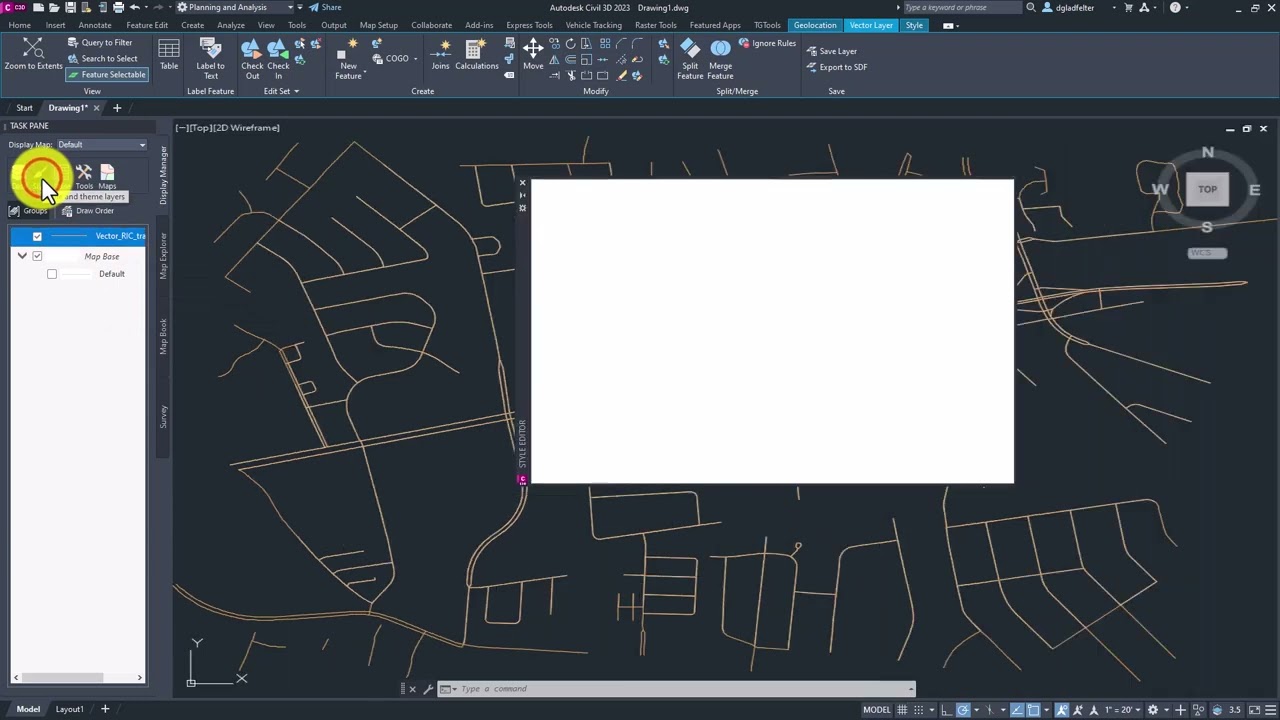
In this video, Donnie "The CAD Geek" Gladfelter shares how to leverage the Map 3D functionality built into Civil 3D to label GIS data as AutoCAD MTEXT entities.
#Autodesk #AutoCAD #Map3D #civil3d
#Autodesk #AutoCAD #Map3D #civil3d
 0:09:44
Creating AutoCAD MTEXT Labels From GIS Data with Map 3D
 0:14:58
How To Label Plans Using MTEXT & MLEADERS with AutoCAD CIVIL 3D
 0:01:54
AutoCAD How To Add Text
 0:07:35
How to Create an Attribute Block in AutoCAD
 0:14:00
AutoCAD How To Automate Text using FIELDS - 4 Easy Time Saving Tricks! | 2 Minute Tuesday
 0:14:05
AutoCAD Text Arrows/Leaders Tips, Tricks & Styles! Multi Leader Tutorial | 2 Minute Tuesday
 0:01:26
AutoCAD Classes Leader Shape with ToolPalletes
 0:01:37
AutoCAD How To Make Area With Mtext Command
 0:04:50
Labeling Parcels AutoCAD Civil 3D
 0:06:30
AutoCAD Convert Text to MTEXT & How to Curve Text! Quick Tips | 2 Minute Tuesday
 0:01:51
how to convert mtext to mleader in autocad
 0:01:29
How to Create 3D Text in AutoCAD | AutoCAD 3D Text Quick & Easy Method Tutorial
 0:00:27
AutoCAD Tutorial: How to Import Text using MTEXT Command for Efficient Drafting
 0:06:00
Create Texts - AutoCAD 2024 Tutorials
 0:06:01
Annotative Text in AutoCAD
 0:01:08
AutoCAD Tutorial Auto Numbering Text and Mtext
 0:01:51
AutoCAD 2018 Tutorial for Beginners 87 HOW TO EXPLODE THE TEXT IN AUTOCAD 2018#
 0:06:26
AutoCAD Map Basic Connect, Query, and Label
 0:05:15
What is ANNOTATION SCALE and how to use ANNOTATIVE DIMENSIONS in AUTOCAD
 0:20:48
Line & Curve Labels - AutoCAD Civil 3D
 0:20:14
Simple Building Outline with Hatch and Labels in Civil 3D
 0:02:23
Auto Numbering In AutoCAD
 0:00:32
AutoCAD Hidden Lines not Showing in Paper Space / Layout | Appear Solid in Layout
 0:00:59
Export autocad Text to excel TTT
Комментарии