filmov
tv
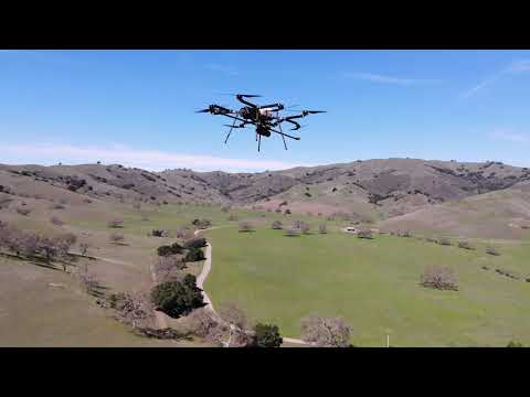
Routescene UAV LiDAR system mounted on Sykfront Perimeter 8 drone

Показать описание
Improve the efficiency of UAV LiDAR surveys with longer flight times
Small improvements to a drone LiDAR survey can make big differences to its' efficiency, productivity and safety. A major limiting factor for any UAV survey is the drone's battery life which, along with the weight of the payload, impacts on the drone's flight time. Imagine the improved productivity and scope of work which could be undertaken if the drone's flight time could be significantly increased.
Skyfront and Routescene explored the impact on productivity of using the longest endurance hybrid gas-electric multicopter drone, the Skyfront Perimeter 8.
The teams tested the Skyfront Perimeter 8 drone carrying a Routescene UAV LiDAR system at the Skyfront headquarters in Menlo Park, California, USA. The Skyfront Perimeter 8 is an 8 rotor hybrid- electric UAV designed for carrying heavier payloads such as LiDAR. The results: the Perimeter 8 drone was able to fly for a total of 3 hours carrying the Routescene payload.
Due to the longer flight times, only one take-off and landing site was required, removing the need to travel between sites to repeatedly set up. In addition, a considerable amount of time was saved simply by eradicating turn-around times to replace batteries. We estimated that by achieving 3 hours of flight time at 5m/s you can readily cover 54 survey line kilometres, which is more than 1.5km sq of area. This is equivalent to roughly 10 x M600 flights, which would normally take two days to complete.
The Routescene UAV LiDAR system has been designed to maximise productivity, with a solid state disc onboard capable of storing over 12 hours worth of data, more than enough for a full day in the field. The quality of the data being collected is monitored in real-time during the entire drone survey using Routescene's QA Monitor, a web based app, to make sure you leave the survey site with the data you need. At the end of the survey the data can be downloaded and checked in the field using Routescene's LidarViewer Pro data processing software.
Longer flight times have a positive impact on safety too. The riskiest parts of a UAV flight are the take-offs and landings, when the drone is under manual control and hence when accidents are most likely to occur. Reducing the number of take-offs and landings obviously directly reduces the probability of an accident.
 0:00:21
 0:00:21
 0:00:21
 0:01:09
 0:00:27
 0:04:55
 0:00:47
 0:02:23
 0:01:01
 0:01:18
 0:00:52
 0:06:19
 0:02:29
 0:01:08
 0:02:10
 0:02:03
 0:02:42
 0:01:32
 0:01:47
 0:01:19
 0:01:08
 0:58:17
 0:00:08
 0:00:37