filmov
tv
How to edit vertices in ArcGIS

Показать описание
#gis #arcgiseditor #gistopology #shapefileedit #arcgis #arcmap #gistutorial #geospatialanalysis #shapefilecorrection #verticesedit #editvertices
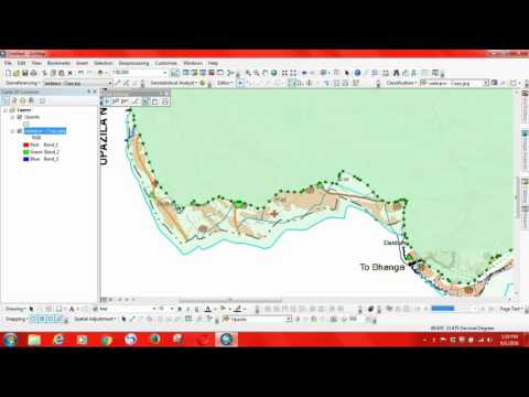
Sometimes we made mistake during digitizing from scanned image or jpeg image. Edit vertices is then needed to fix the error.
When the Edit tool is active and you are editing the shape of a feature, the Edit tool pointer changes from a black arrow to a white arrow to show you can directly select vertices and modify segments. The black arrow pointer is shown when you are working with whole features rather than the individual vertices and segments that make up the feature.
Edit vertex in ArcGIS
How to edit vertices
How to fix vertix
Fix vertices in ArcGIS
"arc gis tutorial"
"arcgis 10 tutorial"
"arcgis 10.2 tutorial"
"arcgis online tutorial"
"arcgis tutorial"
"arcgis tutorial video"
"arcgis video tutorials"
"georeferenced maps"
"georeferenced pdf maps"
"georeferencing"
"georeferencing arcmap"
"georeferencing in gis"
"rms gis"
"tutorial arcgis"
"aerial remote sensing"
"arc gis course"
"arc gis program"
"arc gis training"
"arcgis"
"arcgis arcmap"
"arcgis online"
"arcmap"
"geography" earth
"geospacial"
"geospatial"
"geospatial systems"
"gis"
"gis online tutorial"
"gis software"
"open source remote sensing software"
"remote"
"remote sensing meaning"
"remote sensing training"
"sensor"
"what is a remote sensing"
"what is remote sensing technology"
"whats remote sensing"
"geo data mapping"
"geographic information system definition"
"geographical data analysis"
"geospatial information systems"
"geoprocessing arcgis"
"gis data analysis"
"gis tools"
"hadoop arcgis"
"spatial analyst"
"arcgis editor"
"arcgis editor toolbar"
"arcgis help 10.2"
"desktop editor"
"gis editing"
"gis editor"
"how to create shapefile in arcgis"
"topology arcgis"
“arcgis arcmap”
“arcgis clip”
“arcgis data management tools”
“arcgis mosaic”
“arcgis spatial analyst”
“clip arcgis”
“clip raster arcgis”
“data clip”
“data management tools arcgis”
“raster”
“raster arcmap”
“raster data”
“raster image”
 0:04:04
 0:05:17
 0:04:29
 0:01:00
 0:00:54
 0:00:16
 0:03:39
 0:02:56
 0:10:15
 0:00:27
 0:20:56
 0:00:16
 0:00:31
 0:03:46
 0:00:27
 0:00:17
 0:04:09
 0:00:10
 0:03:16
 0:10:36
 0:03:10
 0:00:55
 0:00:42
 0:00:51