filmov
tv
Types of Clouds – Quiz Edition

Показать описание
#clouds #weather #lighthouselab #ngscience @NGScience
Clouds are a collection of tiny water droplets or ice crystals that float in the air. Scientists classify clouds by their appearance, composition and altitude above the Earth's surface. Let's look at some of the different types of clouds and their characteristics.
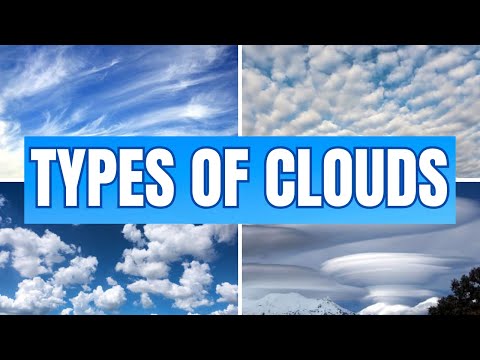
Cirrus clouds are thin, high clouds made up of ice crystals. They often look like wispy, white streaks in the sky. Cirrus clouds do not produce precipitation.
Cirrocumulus clouds composed of ice crystals and are thin, white, and often arranged in rows or waves. Cirrocumulus clouds do not produce precipitation, but they may indicate stable weather in the near future.
Like other clouds at high altitudes, cirrostratus clouds made are of ice crystals and are generally uniform and spread out over a large area.
Altocumulus clouds are mid-level clouds that usually form in the late morning or early afternoon. They are often the first sign of an approaching storm. These clouds are usually white or gray, and they may have a slightly wavy or lumpy appearance. Altocumulus clouds can sometimes produce light rain or snow.
Altostratus clouds are a type of middle-level cloud. They are generally uniform clouds that can cover the entire sky. They are often thick enough to block the Sun, but they may also allow the Sun to peek through. Thick or widespread altostratus clouds can produce light precipitation in the form of rain or snow.
Nimbostratus clouds are a type of low-level cloud characterized by a generally uniform gray or dark gray appearance. They are often associated with precipitation, and can produce continuous light rain or snow for several hours.
Stratocumulus clouds are low-level clouds that often appear as a series of rounded masses. They can be either thick or thin, and may produce light rain or drizzle.
Stratus clouds are a low-level cloud type that are generally uniform in appearance. They can form when a layer of warm air is lifted over a layer of colder air, and they often produce light precipitation.
Cumulus clouds are large, fluffy clouds that look like cotton balls. They are often seen on a sunny day. Cumulus clouds can produce precipitation if they grow tall enough and the air inside is cold enough.
Cumulonimbus clouds are large, dense, and vertically-developed clouds that are often associated with thunderstorms. These clouds can grow to heights of over 16 kilometers (10 miles), and are capable of producing heavy precipitation, strong winds, hail, and even tornadoes.
What clouds are in the sky in your area today? How do the types of clouds in the sky change throughout the year?
Quick Quiz:
1. Which type of clouds are thin, high clouds made up of ice crystals?
A. Cirrocumulus
B. Nimbostratus
C. Cirrus
D. Cumulonimbus
Answer: C. Cirrus
2. Cirrocumulus clouds often indicate that stormy weather is approaching.
Answer: False. Cirrocumulus clouds may indicate stable weather in the near future.
3. What type of precipitation can altocumulus clouds sometimes produce?
Answer: Light rain or snow
4. Which clouds are characterized by their uniform gray or dark gray appearance and are often associated with continuous light rain or snow?
A. Altostratus
B. Stratocumulus
C. Nimbostratus
D. Cumulus
Answer: C. Nimbostratus
5. Cumulus clouds are large, fluffy clouds that look like ________.
Answer: cotton balls
6. Stratus clouds can form when a layer of warm air is lifted over a layer of colder air.
Answer: True
7. What type of clouds can grow to heights of over 16 kilometers and can produce heavy precipitation, strong winds, hail, and even tornadoes?
Answer: Cumulonimbus
8. Which of the following cloud types are mid-level clouds that can be white or gray and have a slightly wavy or lumpy appearance?
A. Cirrostratus
B. Altocumulus
C. Stratocumulus
D. Cumulonimbus
Answer: B. Altocumulus
Clouds are a collection of tiny water droplets or ice crystals that float in the air. Scientists classify clouds by their appearance, composition and altitude above the Earth's surface. Let's look at some of the different types of clouds and their characteristics.
Cirrus clouds are thin, high clouds made up of ice crystals. They often look like wispy, white streaks in the sky. Cirrus clouds do not produce precipitation.
Cirrocumulus clouds composed of ice crystals and are thin, white, and often arranged in rows or waves. Cirrocumulus clouds do not produce precipitation, but they may indicate stable weather in the near future.
Like other clouds at high altitudes, cirrostratus clouds made are of ice crystals and are generally uniform and spread out over a large area.
Altocumulus clouds are mid-level clouds that usually form in the late morning or early afternoon. They are often the first sign of an approaching storm. These clouds are usually white or gray, and they may have a slightly wavy or lumpy appearance. Altocumulus clouds can sometimes produce light rain or snow.
Altostratus clouds are a type of middle-level cloud. They are generally uniform clouds that can cover the entire sky. They are often thick enough to block the Sun, but they may also allow the Sun to peek through. Thick or widespread altostratus clouds can produce light precipitation in the form of rain or snow.
Nimbostratus clouds are a type of low-level cloud characterized by a generally uniform gray or dark gray appearance. They are often associated with precipitation, and can produce continuous light rain or snow for several hours.
Stratocumulus clouds are low-level clouds that often appear as a series of rounded masses. They can be either thick or thin, and may produce light rain or drizzle.
Stratus clouds are a low-level cloud type that are generally uniform in appearance. They can form when a layer of warm air is lifted over a layer of colder air, and they often produce light precipitation.
Cumulus clouds are large, fluffy clouds that look like cotton balls. They are often seen on a sunny day. Cumulus clouds can produce precipitation if they grow tall enough and the air inside is cold enough.
Cumulonimbus clouds are large, dense, and vertically-developed clouds that are often associated with thunderstorms. These clouds can grow to heights of over 16 kilometers (10 miles), and are capable of producing heavy precipitation, strong winds, hail, and even tornadoes.
What clouds are in the sky in your area today? How do the types of clouds in the sky change throughout the year?
Quick Quiz:
1. Which type of clouds are thin, high clouds made up of ice crystals?
A. Cirrocumulus
B. Nimbostratus
C. Cirrus
D. Cumulonimbus
Answer: C. Cirrus
2. Cirrocumulus clouds often indicate that stormy weather is approaching.
Answer: False. Cirrocumulus clouds may indicate stable weather in the near future.
3. What type of precipitation can altocumulus clouds sometimes produce?
Answer: Light rain or snow
4. Which clouds are characterized by their uniform gray or dark gray appearance and are often associated with continuous light rain or snow?
A. Altostratus
B. Stratocumulus
C. Nimbostratus
D. Cumulus
Answer: C. Nimbostratus
5. Cumulus clouds are large, fluffy clouds that look like ________.
Answer: cotton balls
6. Stratus clouds can form when a layer of warm air is lifted over a layer of colder air.
Answer: True
7. What type of clouds can grow to heights of over 16 kilometers and can produce heavy precipitation, strong winds, hail, and even tornadoes?
Answer: Cumulonimbus
8. Which of the following cloud types are mid-level clouds that can be white or gray and have a slightly wavy or lumpy appearance?
A. Cirrostratus
B. Altocumulus
C. Stratocumulus
D. Cumulonimbus
Answer: B. Altocumulus
 0:06:06
Types of Clouds – Quiz Edition
 0:08:14
What Do You See in the CLOUDS - Quiz
 0:02:14
TYPES OF CLOUDS
 0:03:23
TYPES OF CLOUDS || SCIENCE EDUCATIONAL VIDEO FOR CHILDREN
 0:09:22
'How Well Do You Know Your CLOUDS☁️🌤️⛈️? | Ultimate CLOUDS Quiz Challenge'
 0:04:15
Types Of Clouds - The Dr. Binocs Show | Best Learning Videos For Kids | Peekaboo Kidz
 0:05:06
Weather 101: A Tutorial on Cloud Types
 0:06:11
Types of Clouds l Types of Clouds upsc l Types of Clouds MCQ l MCQ on Types of Clouds
 0:06:22
Play the Cloud Memory Game! - #sciencegoals
 0:01:56
10 Kinds of Clouds That Will Amaze You! Quiz plus
 0:01:09
Quiz 1.40- Types of Clouds - #brainburst #trivia #quiz #brainbustersquiz #clouds #weather
 0:00:12
What Kind of Cloud is This? #shorts #quiz
 0:05:02
K-2nd: KidsQuest - Clouds
 0:11:32
Cloud Facts!
 0:00:11
5 Common Types of Clouds
 0:06:25
Cloud types: stratus, cumulus, cirrus, nimbus + strange formations
 0:00:19
What Types of Clouds Are Commonly Targeted for Seeding? #sciencequiz #cloudseeding #dubaiflooding
 0:03:57
General Knowledge Quiz
 0:00:58
Earth Science Basics Quiz: Test Your Knowledge on Rocks, Wind, Clouds, and More! 🌍
 0:03:57
Types of clouds 03 03 21
 0:00:40
Types of Clouds, Watch the full video, https://youtu.be/BmvbyVbz6eo, to answer the quiz
 0:02:38
The Cloud Song | Fun Facts About Clouds | Cloud Song for Kids | Silly School Songs 🎶
 0:09:31
How You'd Look Living on Different Planets - 3D Animation
 0:08:13
How High You Could Jump on Different Planets in 3D
Комментарии