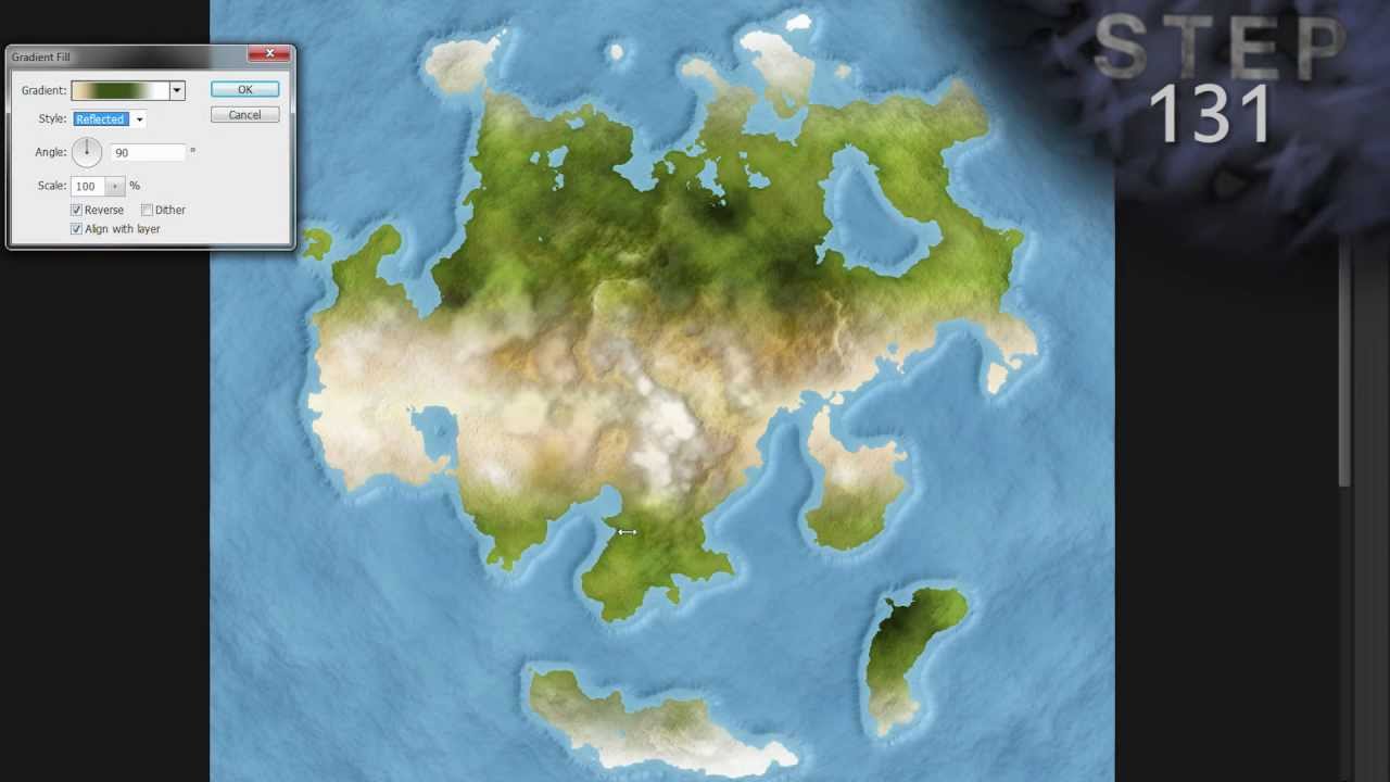
Atlas Map Style Tutorial - 6 of 7 (Photoshop)

preview_player
Показать описание
Part six of a seven part series on how to create an atlas map style in Adobe Photoshop. I did not develop the techniques used to create the style; I only created a new tutorial about it.

- 6 of 7 - Step 130-194 -

Licensed under Creative Commons: By Attribution 3.0
Рекомендации по теме
Комментарии
Автор

I just typed a bunch of stuff, and I was toward the end of your video. I got so excited I pressed the next video link without pressing the post button. Anyway, you did a really great job on these videos. Your voice is nice to listen to, you have a general accent and you explain the steps very simply, even when you are in the 6th video, you still take time to explain the shortcuts. The onscreen text is awesome. Two things I did to change up are cutting the rivers out of the land directly, so that it looks like the sea creeps inland. I also put some crevices and ridges in the ocean. Great job, and I hope you do more.

whitehorn
Автор

Dude, you got to be the best educator on youtube. I fully endorse future efforts!

Hunnah
Автор

Actually once I read your written guide you covered a lot of that. I bet you would be the best person to do basic PS tutorials in general. You have a great talent for teaching PS! Thanks for all the hard work!

thecfi
Автор

Awesome stuff - but would like to see you do a tutorial describing how certain effects, blends etc work. And how to best use them etc.

thecfi
Автор

For some reason my mountains just look like dark lines and don't actually appear very "mountainous" like yours do. Any idea how to correct this?

TWKinzer
Автор

Thanks for the feedback and suggestion - I'll keep it in mind when I start working on another tutorial!

Kindari
Автор

It'd be nice if there were tips somewhere on how to cope with map distortion. As in, I was trying to create a global map and (inevitably) the polar regions were hopelessly distorted, which was especially frustrating as one of my continents crosses the north pole. Ultimately, my solution was to create a separate map for everything over 50-70o latitude.

The issue I'm grappling with now is figuring out distance, straight-lines north-to-south over maybe 500km become pretty inaccurate. The workaround I have at the moment is plotting real-world locations, like Moscow or Reykjavik, on my map using latitude and longitude, then using programs online which calculate distance.

Austrolopithe
Автор

Can I ask how to get rid of the dark green blotches? I can't seen to go over them and I don't know how to lighten them up. Thanks!

MacbookJesse
Автор

is it bad that I use Adobe fireworks then transfer that picture to Photoshop? because photo shop does not have cool textures like fireworks

JoseRivera-fmfo
Автор

I had something odd happen while following step 160, when I alt+dragged the Color overlay, it copied the overlay other to the other snow layers, but it added the overlay, and did not replace the existing one. Note: I'm using PS CC 2015.5 I ended up having to go into each color overlay individually and edit them as was done with the Mountains Snow layer.

DaemosDaen
Автор

Hah, yeah. Thanks for such a great visual tutorial!

Sarinatu
Автор

my terrain look nothing like this? I only has black faded lines for mountains, have I done something wrong??

CanadianBorn
Автор

Probably the simplest way to do this is by drawing on layer Land Gradient Adjust with a lighter shade of green. I usually start with the dark green (#405018), then increase the brightness and decrease saturation so it's almost gray. This will brighten the green from Land Gradient without making it turn a lime color.

Kindari
Автор

heheh, I take it you worked out the issue in video 3? Thanks for watching!

Kindari
Автор

The dark spots bother me too much, if I dont find a way to delete them I quit making this.

matthewmercado
Автор

>2011+4
>relying on anything else than Wilbur to make your rivers

ISHYGDDT!

xylonbeta
welcome to shbcf.ru