filmov
tv
GIS Maps Rendered in Photoshop

Показать описание
This video demonstrates how to render a map in Photoshop, that was created in ArcMap.
 0:38:15
GIS Maps Rendered in Photoshop
 0:07:25
Architecture Site Analysis with AI: No GIS Knowledge Required!
 0:10:26
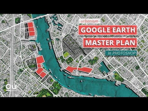
Google Earth Master Plan in Photoshop [ Quickest Method ]
 0:06:56
EASY Site Plan No DIGIMAP or TRACING in UNDER 10 MINUTES
 0:13:43
Architecture Site Analysis - A quick and powerful method!
 0:11:53
How to Make those Cool 3D Vintage Topo Maps: pt1
 0:16:19
Master Plan with Google Earth and Photoshop + Animating in After Effects
 0:19:39
Maps in Blender 3.5: Custom Height Maps (DEM) + Color Maps (Photoshop, No Plugins, Blender 3.5)
 0:08:07
3 FREE Digimap Alternatives for Site Analysis and Site Plans
 0:11:09
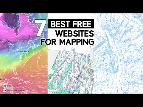
BEST FREE websites for mapping | Free base map files for site analysis
 0:13:21
Google Earth Master Plan in Photoshop
 0:01:00
How to Make Site Analysis Tutorial #Shorts
 0:16:18
QGIS and Blender Hillshade TUTORIAL - Create Beautiful Hillshade ART
 0:40:35
Introduction to ArcGIS Maps for Adobe Creative Cloud
 0:12:05
Videoguide - Import Terrain, BlenderGIS, Google Maps, Landscape, Buildings, Geographic Information
 0:37:16
Photoshop Siteplan Rendering Tutorial #architecture #tutorial #qreativehome
 0:02:12
GIS: Working with PNG images in Photoshop
 0:00:15
ArcGIS Urban Plan Creation
 0:04:53
GIS Tutorial 05- Georeferencing using Adobe Photoshop CS6 part 2
 0:15:38
Landscape Axon Tutorial using Google Earth 🌎 & Photoshop [Without plug-ins]
 0:27:54
ArcGIS Maps for Adobe Creative Cloud: An Introduction
 0:12:58
How to create Pakistan Population Density Map render in QGIS and 3D raytracing Tutorial
 0:16:55
Make a Vintage Forestry Map 3D using Modern Forestry Data
 0:26:19
ArcGIS Maps for Adobe Creative Cloud: An Introduction
Комментарии