filmov
tv
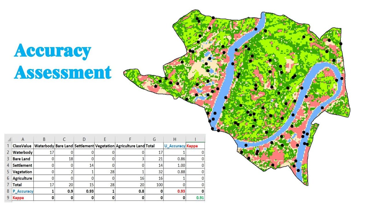
Accuracy Assessment of a Land Use and Land Cover Map
Показать описание
How to utilize ArcGIS' accuracy assessment and confusion matrix tools to validate land use and land cover changes map. I hope you guys will like this tutorial.
Thank you.
#LandCoverMapValidation
#GISAccuracyAssessment
#LandUseClassificationAccuracy
#LandUseMapQuality
#RemoteSensingAccuracyAssessment.
#LandUseLandCoverMapAccuracy.
#LandCoverMapEvaluation
#GISMapAccuracy
#LandUseMappingQuality
#LandCoverClassificationValidation
#RemoteSensingMapValidation
Thank you.
#LandCoverMapValidation
#GISAccuracyAssessment
#LandUseClassificationAccuracy
#LandUseMapQuality
#RemoteSensingAccuracyAssessment.
#LandUseLandCoverMapAccuracy.
#LandCoverMapEvaluation
#GISMapAccuracy
#LandUseMappingQuality
#LandCoverClassificationValidation
#RemoteSensingMapValidation
 0:10:06
Accuracy Assessment of a Land Use and Land Cover Map
 0:24:28
Accuracy Assessment | Kappa Coefficient | User Accuracy| Producer Accuracy| Overall Accuracy
 0:02:56
Google Earth Engine - Classification Accuracy Assessment
 0:05:22
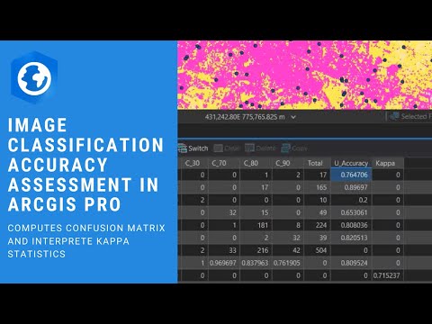
Quick Image Classification Accuracy Assessment in ArcGIS Pro
 0:06:05
accuracy assessment of land cover classification through google earth
 0:57:08
Accuracy Assessment || Kappa Coefficient || Overall Accuracy || User's Accuracy || Producer Acc...
 0:33:39
Land Cover Classification and Accuracy Assessment - Full Tutorial
 1:43:46
NASA ARSET: Introduction to Accuracy Assessments, Part 1/2
 0:16:50
accuracy assessment using arcgis 10.5 tutorial 6 | land use land cover map
 0:06:53
how to perform Accuracy assessment of land cover classification in ERDAS using Google earth
 0:11:34
RS & GIS QA26 Validation of LULC in ARCGIS using the Accuracy Assessment and Confusion Matrix to...
 0:06:04
Accuracy Assessment of Supervised Classification in Erdas Imagine
 0:13:24
Accuracy Assessment of an image classification in ArcGIS | ArcGIS Tutorial | v31
 0:10:38
Accuracy Assesment In Quantum GIS || A complete Tutorial
 0:11:06
accuracy assessment of a land cover classification
 0:21:16
Accuracy Assessment of LULC map in QGIS using Semi automatic Classification Plugin
 0:29:17
Classification accuracy assessment and errors
 0:07:24
Accuracy Assesment of Image Classification in ArcGIS Pro ( Confusion Matrix and Kappa Index )
 2:14:25
NASA ARSET: Land Cover Classification and Accuracy Assessment in Google Earth Engine, Part 2/3
 0:07:07
Google Earth Engine Tutorial: #2 Accuracy Assessment
 0:02:35
How to do accuracy assessment in erdas imagine 14
 0:15:27
Accuracy Assessment of Supervised Landsat Image Classification in ArcMap Software: Part 1
 0:21:07
Accuracy assessment landuse using historical google earth imagery
 0:32:10
Lecture 49: Accuracy Assessment of Classification
Комментарии