filmov
tv
Inverse Distance Weighted (IDW ) method in ArcGIS || Interpolation in Arc GIS

Показать описание
IIn this live youtube video I will discuss the IDW technique in ArcGIS.
Interpolation predicts values for cells in a raster from a limited number of sample data points. It can be used to predict unknown values for any geographic point data, such as elevation, rainfall, chemical concentrations, noise levels, and so on.
*******************************************************************************************************
Advances in Geographical Research
Learn research methodology online with courses of Advanced Geospatial technologies, statistical methods, and Machine Learning algorithms.
*******************************************************************************************************
WhatsApp Group for subscribers:
***************************************************************************************
Playlist
1. Basics Remote sensing
2. MCDM and ML
3. Arc GIS
4. Free online data download
5. Advanced Excel
SUBSCRIBE to the YouTube channel Dr. Jayanta Das, to get notification about our recent lecture uploads on Advances in Geographical Research.
ALL RIGHTS RESERVED.
#DrJayantaDas
 0:06:57
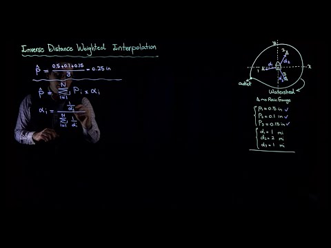
Inverse Distance Weighted Interpolation Worked Example
 0:08:50
Kriging vs Inverse distance weighted (IDW)
 0:07:35
Interpolation of Rainfall: Inverse Distance Weighted (IDW) Method
 0:22:04
Inverse distance weighting for creating a surface from sample points
 0:02:37
IDW (Inverse Distance Weight) ArcGIS 10.3 | GIS and Remote Sensing Analytics
 0:10:54
Inverse distance weighted (IDW) with Negative Z Value || How to Add excel data to ArcGIS
 0:10:05
Inverse Distance Weighted Interpolation | Important for GATE/NET & IIT-JAM | GeologyConcepts.c...
 0:01:53
Interpolation, Inverse distance weighted IDW technique in ArcMap
 0:02:05
(RTR 2.1.1.6) Inverse Distance Gridding
 0:05:42
IDW (Inverse Distance Weighted) method using ArcGIS
 0:04:45
Interpolation in GIS Inverse Distance Weighting (IDW)
 0:02:24
Spatial Inverse distance Weighted Interpolation | Kriging IDW
 0:09:32
Inverse Distance Weighting Conceptual
 0:00:47
IDW INVERSE DISTANCE WEIGHTED
 0:01:19
PYTHON : Inverse Distance Weighted (IDW) Interpolation with Python
 0:03:30
Rumus-Ilustrasi Inverse Distance Weighted (IDW)
 0:11:27
Inverse Distance Weighting Example
 0:58:07
M11B Inverse distance weighted interpolation
 0:28:01
Inverse Distance Weighted (IDW ) method in ArcGIS || Interpolation in Arc GIS
 0:06:37
Inverse Distance Weighted (IDW)
 0:07:36
IDW R
 0:06:13
Performing Inverse Distance Weighting (IDW) Interpolation and Contour Fill Plot using Python
 0:03:59
Inverse Distance Weighting IDW interpolation by ArcGis (SI3) intermezzo
 0:05:29
ArcGIS Pro: Spatial Interpolation IDW (Inverse Distance Weighting)
Комментарии