filmov
tv
Using Overpass API

Показать описание
This visual training set has been prepared by the GISLayer team and has been prepared to quickly teach users the Web-based GIS editor. You can learn successfully by following the training set we have listed in the most correct way step by step and trying it on your mobile device.
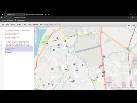
## Using Overpass API
1. In this tutorial video you will learn how to use the overpass API.
2. With the Overpass API option in the Services menu, the overpass panel is opened.
3. In order to save the obtained data, if there is no vector layer on the map, a new layer can be created by using the create new layer button from the data menu or the quick layer creating button in the panel can be used.
4. Filtering methods to be applied are added. There can be multiple filters.
5. The query is run with the query button. The minimum zoom level of the map is set to 14. Each time the query button is clicked, a query is made on the area that appears on the map at that moment and the obtained data is added to the layer.
 0:07:11
 0:02:30
 0:02:05
 0:04:58
 0:08:43
 0:16:38
 0:10:31
 0:22:42
 0:26:37
 0:01:38
 0:01:30
 0:01:00
 1:18:20
 0:01:36
 0:05:23
 0:46:42
 0:34:22
 1:01:28
 0:02:04
 0:01:07
 0:25:30
 0:16:57
 0:00:20
 0:03:36