filmov
tv
Geocode with google map's API key using Python

Показать описание
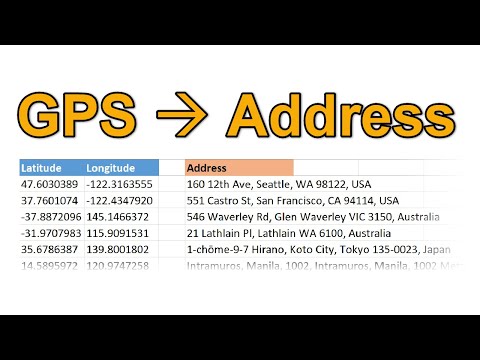
In this video, I demonstrate how to get geographical information from Google Map's Geocoding API. I, at first, show how to get the API key from google, and then I describe how to get geographical information (i.e., latitude and longitude) for addresses using python’s googlemaps module.
IMPORTANT:
This video does not include one tiny but essential information. You also need to enable the Geocoding API before running the codes on Python. For enabling the Geocoding API:
- Go to the dashboard of your “Google APIs.”
- Click “Library” on the sidebar on the left.
- Write “Geocoding API” in the search box.
- Finally, select and enable the Geocoding API from the search result.
 0:03:16
How to convert addresses to map coordinates with Geocoding API
 0:18:56
Google Maps Geocoding API Tutorial - by Lester Hernandez Alfonso
 0:16:21
17. Using Google's Geocoding API to Convert an Address Into Coordinates #education #programmer
 0:08:20
Geocode in R with ggmap (and a free Google API key)
 0:02:40
How to Get a Google Maps API Key in 2 Mins
 0:03:13
Google Maps Javascript API Tutorial | How to use the SDK for Geocoding
 0:03:24
Geocoding in Excel with Google Maps API
 0:09:29
How to Use Google Maps API in Python | Geocoding, Reverse Geocoding, and Calculating Distance (2025)
 0:08:14
Geocode Data Using Google Maps
 0:00:45
Try an API: OpenStreetMap 🗺️ Geocoding data with the Nominatim OpenStreetMap API #tryanapi #api
 0:07:17
Geocode with google map's API key using Python
 0:05:21
Geocode with google map s api key using python
 0:04:55
GPS coordinates to Location
 0:04:25
Geocoding API | Maps Javascript API | Geocoding API for Map | Sekharmetla | Harisystems
 0:03:58
How to Use Google Maps API 2025 [New Method]
 0:00:36
Google Maps API (reverse Geocoding demo)
 0:18:51
How to use the Google Geocoding API in Power BI | Quickly find Longitude and Latitude Coordinates
 0:05:40
How to Create API Keys for Google Maps and Geocoding.
 0:32:47
Google Geocode API & JavaScript Tutorial
 0:07:53
Python requests and the Google Maps Geocoding API
 0:07:09
Geocoding and Reverse #Geocoding in #Salesforce ☁️ | Google Maps APIs
 0:12:31
Build a React.js Google Maps Autocomplete & Geocoding API to Display Address Details, Photos Dat...
 1:13:59
#7 Direction & Geo-Coding Api in Google maps #maps #googlemaps #geocoding #direction
 0:00:30
Google map clustering, places, geocoding, direction api
Комментарии