filmov
tv
Satellite Images Reveal Fault Line And Extent Of Turkey Quake Destruction | Turkey Earthquake

Показать описание
Satellite Images Reveal Fault Line And Extent Of Turkey Quake Destruction | Turkey Earthquake
Satellite photos taken on Thursday (February 9) showed the destruction in several cities and changes to the landscape caused by the deadly earthquake that hit southern Turkey earlier in the week.
The satellite imagery released by Maxar Technologies, showed destroyed grain silos in Kirikhan, a collapsed hospital and toppled buildings in Antakya.
Rescue efforts continue in Turkey as the combined death toll in Turkey and neighbouring Syria crosses 20,000.
It now ranks as the seventh most deadly natural disaster this century, ahead of Japan's 2011 tremor and tsunami and approaching the 31,000 killed by a quake in Iran in 2003.
#rescueturkey #turkeyearthquake2023 #naturaldisasters
n18oc_world
 0:08:25
Satellite Images Reveal Fault Line And Extent Of Turkey Quake Destruction | Turkey Earthquake
 11:55:00
Satellite Images Reveal Fault Line And Extent Of Turkey Quake Destruction | Turkey Earthquake
 6:25:58
Satellite Images Reveal Fault Line And Extent Of Turkey Quake Destruction | Turkey Earthquake
 4:01:41
Satellite Images Reveal Fault Line And Destruction In Turkey | Turkey Earthquake 2023 LIVE | News18
 11:55:00
Satellite Images Reveal Fault Line And Destruction In Turkey | Turkey Earthquake 2023 LIVE | News18
 0:00:43
Satellite images show fault line and damages in Turkey’s earthquake aftermath
 3:04:37
Satellite Images Show Devastation And Fault Line In Turkey | Turkey Earthquake 2023 LIVE | News18
 0:01:00
Shocking Satellite images reveal Turkey earthquake damage
 0:02:02
Turkey-Syria earthquake: Satellite photos reveal the extent of devastation
 0:08:56
Possible Asteroid Crater in Western Australia
 0:00:47
Satellite imagery reveals before and after shots of Turkey earthquake damage
 0:00:43
Satellite images show before and after scale of Turkey earthquake destruction #shorts #turkeysyria
 0:00:37
Turkey Earthquake - Before and After Satellite Images Showing the Damage
 0:01:14
Stanford Study Reveals New Fault Lines Near Bay Area
 0:01:01
Drone footage shows large faultline in southern Turkey after earthquakes
 0:02:11
Satellite Images Show Before And After Earthquake Damage In Turkey | Turkey Earthquake | News18
 0:03:37
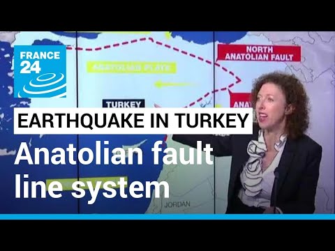
Turkey's anatolian fault system: One of world's most seismically active region • FRANCE 24...
 0:01:55
NASA Radar Data Reveals Fault Movement from Napa Quake
 0:01:20
Satellite imagery captures earthquake devastation in Northwest Syria
 0:00:37
New satellite photos show surface cracks from devastating Turkey earthquake #technology #techorbit
 0:02:40
190-mile-long fissure opened up after Turkey earthquake satellite images show
 0:00:55
Türkiye and Syria earthquake rescue efforts continue. #syria #turkeyearthquake2023
 0:00:52
Colossal Earthquake Surface Ruptures
 1:05:02
Is Our Moon a Giant Hollow Spacecraft?
Комментарии