filmov
tv
228 - Semantic segmentation of aerial (satellite) imagery using U-net

Показать описание
This video demonstrates the process of pre-processing aerial imagery (satellite) data, including RGB labels to get them ready for U-net. The video also demonstrates the process of training a U-net and making predictions.
Code generated in the video can be downloaded from here:
My Github repo link:
The dataset consists of aerial imagery of Dubai obtained by MBRSC satellites and annotated with pixel-wise semantic segmentation in 6 classes. The total volume of the dataset is 72 images grouped into 6 larger tiles. The classes are:
Building: #3C1098
Land (unpaved area): #8429F6
Road: #6EC1E4
Vegetation: #FEDD3A
Water: #E2A929
Unlabeled: #9B9B9B
Images come in many sizes: 797x644, 509x544, 682x658, 1099x846, 1126x1058, 859x838, 1817x2061, 2149x1479
Need to preprocess so we can capture all images into numpy arrays.
Crop to a size divisible by 256 and extract patches.
Masks are RGB and information provided as HEX color code.
Need to convert HEX to RGB values and then convert RGB labels to integer values and then to one hot encoded.
Predicted (segmented) images need to converted back into original RGB colors.
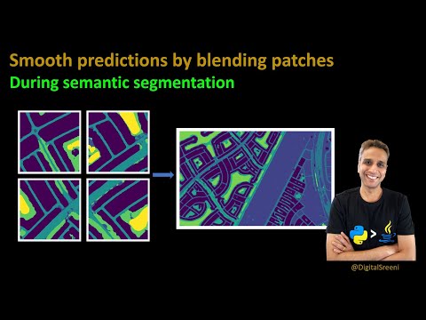
Predicted tiles need to be merged into a large image by minimizing blending artefacts (smooth blending). (Next video)
Code generated in the video can be downloaded from here:
My Github repo link:
The dataset consists of aerial imagery of Dubai obtained by MBRSC satellites and annotated with pixel-wise semantic segmentation in 6 classes. The total volume of the dataset is 72 images grouped into 6 larger tiles. The classes are:
Building: #3C1098
Land (unpaved area): #8429F6
Road: #6EC1E4
Vegetation: #FEDD3A
Water: #E2A929
Unlabeled: #9B9B9B
Images come in many sizes: 797x644, 509x544, 682x658, 1099x846, 1126x1058, 859x838, 1817x2061, 2149x1479
Need to preprocess so we can capture all images into numpy arrays.
Crop to a size divisible by 256 and extract patches.
Masks are RGB and information provided as HEX color code.
Need to convert HEX to RGB values and then convert RGB labels to integer values and then to one hot encoded.
Predicted (segmented) images need to converted back into original RGB colors.
Predicted tiles need to be merged into a large image by minimizing blending artefacts (smooth blending). (Next video)
 0:41:57
228 - Semantic segmentation of aerial (satellite) imagery using U-net
 0:05:04
Image Segmentation, Semantic Segmentation, Instance Segmentation, and Panoptic Segmentation
 0:18:33
229 - Smooth blending of patches for semantic segmentation of large images (using U-Net)
 0:00:55
Semantic segmentation of aerial imagery
 0:00:05
Semantic Segmentation of fields - AERIAL CROP MONITORING - Agriculture AI
 0:05:15
Semantic Segmentation for Aerial Mapping
 0:00:10
Image Semantic Segmentation using Attention U-Net with a Gradient Error Minimizing Loss function 1
 0:00:11
Semantic Segmentation
 0:02:32
Image classification vs Object detection vs Image Segmentation | Deep Learning Tutorial 28
 0:08:11
Semantic Segmentation of Drone images | College Project
 0:45:56
230 - Semantic Segmentation of Landcover Dataset using U-Net
 0:24:05
177 - Semantic segmentation made easy (using segmentation models library)
 0:08:07
LULC classification by semantic segmentation of satellite images using FastFCN
 0:00:17
semantic segmentation
 0:00:35
SEMANTIC SEGMENTATION OF AERIAL IMAGES WITH AN ENSEMBLE OF CNNS | RTCL.TV
 0:00:18
Image Segmentation with Deep Learning 🎨🖼️ - Topic 017 #ai #ml #deeplearning
 0:24:34
204 - U-Net for semantic segmentation of mitochondria
 0:00:25
USE CASE Geospatial - Semantic Segmentation Crops Annotation
 0:00:34
Ignas Budvytis: Label propagation - semantic segmentation of 360° videos - autonomous driving scenes...
 0:38:07
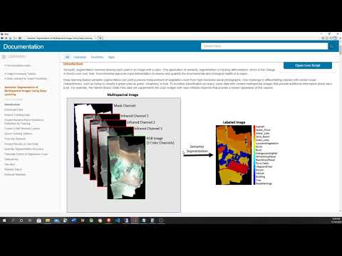
Semantic segmentation of multispectral image using deep learning
 0:30:21
SEMANTIC SEGMENTATION OF AERIAL IMAGES USING DEEP LEARNING | MinorProjectBatch178 VELTECH UNIVERSITY
 0:05:00
Unsupervised Semantic Segmentation of Aerial Images with Application to UAV Localization (Short)
 0:01:19
Semantic Segmentation Demo
 0:31:20
208 - Multiclass semantic segmentation using U-Net
Комментарии