filmov
tv
Image to Image Georeferencing in ArcMap

Показать описание
Steps Image to Image Georeferencing in ArcMap
Georeferencing an image in ArcMap involves aligning it with spatial data, such as a map or other imagery, so that it can be used in a GIS analysis. The following steps can be followed to georeference an image in ArcMap:
Open ArcMap and add the image file to the map document as a layer.
Make sure the Data Frame is set to the appropriate coordinate system for the project.
Click on the Georeferencing drop-down menu and select "Fit to Display."
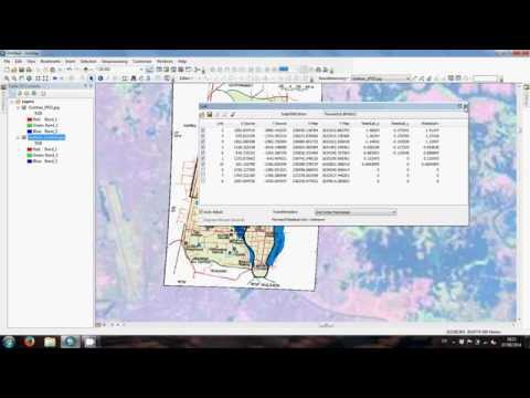
Use the "Add Control Points" tool to select points on the image that correspond to known locations on the map or in other spatial data.
Enter the coordinates for the known locations in the "Link Table" and click "Update Georeferencing" to adjust the image accordingly.
Continue adding control points until the image is accurately aligned with the spatial data.
Once the georeferencing is complete, click on the Georeferencing drop-down menu and select "Update Georeferencing" to save the changes to the image file.
It is important to note that the accuracy of the georeferencing depends on the quality of the control points selected and the accuracy of the spatial data used for reference. It is also recommended to check the georeferenced image against other spatial data to ensure that it aligns properly before using it in any analysis.
Georeferencing an image in ArcMap involves aligning it with spatial data, such as a map or other imagery, so that it can be used in a GIS analysis. The following steps can be followed to georeference an image in ArcMap:
Open ArcMap and add the image file to the map document as a layer.
Make sure the Data Frame is set to the appropriate coordinate system for the project.
Click on the Georeferencing drop-down menu and select "Fit to Display."
Use the "Add Control Points" tool to select points on the image that correspond to known locations on the map or in other spatial data.
Enter the coordinates for the known locations in the "Link Table" and click "Update Georeferencing" to adjust the image accordingly.
Continue adding control points until the image is accurately aligned with the spatial data.
Once the georeferencing is complete, click on the Georeferencing drop-down menu and select "Update Georeferencing" to save the changes to the image file.
It is important to note that the accuracy of the georeferencing depends on the quality of the control points selected and the accuracy of the spatial data used for reference. It is also recommended to check the georeferenced image against other spatial data to ensure that it aligns properly before using it in any analysis.
 0:13:41
Image to Image Georeferencing in ArcMap Tutorial II ArcGIS
 0:11:23
How to do Image to Image Georeferencing in ArcGIS
 0:03:48
Georeferencing JPEG/JPG Image Map or Scanned Map in ArcGIS
 0:06:25
Image to Image Geo-referencing in QGIS 3.14 || Georeferencing/Rectification in QGIS || IT GIS || GIS
 0:07:23
Image to image georeferencing in ERDAS
 0:12:07
Image to Image Georeferencing in ArcGIS Pro ( for Aerial Photographs and Satellite Imagery )
 0:04:44
Image to Image Georeferencing in ArcMap
 0:14:28
QGIS # IMAGE TO IMAGE GEOREFERENCING
 0:05:43
How to do Georeferencing Image to Image in Erdas Imagine 14
 0:23:21
Georeferencing an Image or a Scanned Map using ArcGIS Pro
 0:03:35
Georeferencing a scanned image without lat and long in ArcGIS
 0:07:20
Image to Image Georeferencing in ArcGIS Pro: Control Points Method
 0:11:31
IMAGE TO IMAGE GEOREFERENCING IN QGIS
 0:11:43
Image to Image Georeferencing in ArcGIS
 0:12:15
Image to image georeferencing in QGIS using a docked Georeferencer panel
 0:07:47
How to image to image Georeferencing in urdu/hindi || Lecture Number 8
 0:06:41
Image to image georeferencing in QGIS 3.4
 0:10:04
Image to Image georeferencing in QGIS
 0:08:53
How to Download and Georeferencing Google Earth Image in ArcGIS
 0:10:01
How to download Google Earth Image and Georeference it in ArcGIS software |Georeference ArcMap
 0:16:01
Image to Image Georeferencing in ArcGIS || Rectification in ArcGIS || IT GIS
 0:09:52
Image to Image Georeferencing
 0:05:49
Preparing a google image for georeferencing in ArcGIS
 0:11:33
ArcGIS: Image to Image Georeferencing
Комментарии