filmov
tv
【4K】Kusadasi from Above Turkey - A Different Perspective

Показать описание
I am Burak Mert Filiz and I literally love Kuşadası, my home is here since 14 yo. Every scene of the video I have another memories. So far my favorite drone Footage.The view of Kuşadası from above is fascinating. I hope you also like my Kuşadası cinematic video. And soon I will hit the road, follow me on my new journey.
Welcome to the community! I appreciate your support and help for the channel,
SUPPORT ME - to help me make more videos:
You CAN Like, comment and share it to your friends.
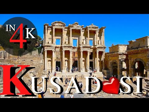
About Kusadasi: Kusadasi is a large resort town on Turkeys Aegean coast, and the center of the seaside district of the same name within Aydın Province. Kuşadası is 95 km (59 mi) south of İzmir, and about 60 km (37 mi) from Aydın. The municipalitys primary industry is tourism. The city is situated along a gulf of the same name in the Aegean. The island of Güvercinada (in English: Pigeon Island) is connected to mainland Kuşadası by a man-made causeway, and is situated adjacent to the large hill of Kese Dağı near the center of town. It is located 95 km (59 mi) south of İzmir, the areas metropolitan centre, and approximately 60–70 km (37–43 mi) in driving distance from the provincial seat of Aydın, depending on the route taken. Its neighbours are Selçuk to the north, Germencik to the north-east, and Söke to the east and south. // The city walls – There were once three gates; one remains. // Kaleiçi Mosque – Built in 1618 by Grand Vizier Öküz Kara Mehmed Pasha. // The Öküz Mehmed Pasha Caravanserai is near the docks. It was built in 1618 as a strong-room for the goods of seamen. // Güvercin Adası (Pigeon Island in English) – The peninsula/island at the end of the bay, which has a castle and swimming beaches, including a private beach and cafe with a view back across the bay to the harbour of Kuşadası. Public beaches are located at the back of the peninsula, towards the open sea. // Kirazli – Traditional Turkish village 12 kilometres (7.5 mi) from Kuşadası. // Yılancı Burnu – A second peninsula beyond Güvercin Ada. Possibly the location of the original settlement of Neopolis. Some walls are visible. There are beaches and beach clubs here. // Several aqua-parks with wave-pools and white-water slides are located near the town. // Ladies Beach – Very close to the town center, one of the primary tourist attractions. // Kadıkalesi – Venetian/Byzantine castle, 10 kilometres (6.2 mi) along the Kuşadası-Davutlar road. // Panionium – 25 km (16 mi) south of Kuşadası, situated along the Davutlar-Güzelçamlı road. Once the central meeting place of the Ionian League. [Source: wikipedia // Google] #kusadasi #türkiye #solotraveler
Welcome to the community! I appreciate your support and help for the channel,
SUPPORT ME - to help me make more videos:
You CAN Like, comment and share it to your friends.
About Kusadasi: Kusadasi is a large resort town on Turkeys Aegean coast, and the center of the seaside district of the same name within Aydın Province. Kuşadası is 95 km (59 mi) south of İzmir, and about 60 km (37 mi) from Aydın. The municipalitys primary industry is tourism. The city is situated along a gulf of the same name in the Aegean. The island of Güvercinada (in English: Pigeon Island) is connected to mainland Kuşadası by a man-made causeway, and is situated adjacent to the large hill of Kese Dağı near the center of town. It is located 95 km (59 mi) south of İzmir, the areas metropolitan centre, and approximately 60–70 km (37–43 mi) in driving distance from the provincial seat of Aydın, depending on the route taken. Its neighbours are Selçuk to the north, Germencik to the north-east, and Söke to the east and south. // The city walls – There were once three gates; one remains. // Kaleiçi Mosque – Built in 1618 by Grand Vizier Öküz Kara Mehmed Pasha. // The Öküz Mehmed Pasha Caravanserai is near the docks. It was built in 1618 as a strong-room for the goods of seamen. // Güvercin Adası (Pigeon Island in English) – The peninsula/island at the end of the bay, which has a castle and swimming beaches, including a private beach and cafe with a view back across the bay to the harbour of Kuşadası. Public beaches are located at the back of the peninsula, towards the open sea. // Kirazli – Traditional Turkish village 12 kilometres (7.5 mi) from Kuşadası. // Yılancı Burnu – A second peninsula beyond Güvercin Ada. Possibly the location of the original settlement of Neopolis. Some walls are visible. There are beaches and beach clubs here. // Several aqua-parks with wave-pools and white-water slides are located near the town. // Ladies Beach – Very close to the town center, one of the primary tourist attractions. // Kadıkalesi – Venetian/Byzantine castle, 10 kilometres (6.2 mi) along the Kuşadası-Davutlar road. // Panionium – 25 km (16 mi) south of Kuşadası, situated along the Davutlar-Güzelçamlı road. Once the central meeting place of the Ionian League. [Source: wikipedia // Google] #kusadasi #türkiye #solotraveler
 0:04:14
【4K】🇹🇷 Kusadasi from Above 🔥 TURKEY 2022 🔥 Cinematic Wolf Aerial™ Drone Film
 0:03:38
Mesmerizing Kusadasi: A Stunning 4K Drone Tour | Ultimate Kusadasi Drone footage in 4k 🚁✨
 0:04:30
【4K】Kusadasi from Above Turkey - A Different Perspective
 1:00:42
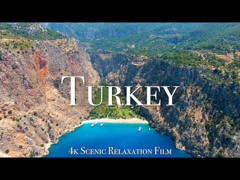
Turkey 4K - Scenic Relaxation Film With Calming Music
 0:07:56
Kusadasi. Turkey 🇹🇷 (4K UHD)
 0:05:18
Kusadasi Turkey Cruise Port Guide | Top Things to Do in Kusadasi (4K)
 0:01:10
VIDEO: KUSADASI (TURQUÍA) 4K
 0:05:18
Kuşadası, Turkey - Drone Footage - 4K HDR
 0:03:00
One of the most charming cities for tourists in Turkey - Kuşadası, 4K
 0:34:19
Kuşadası City Tour | 23 April 2022 Turkey [4K UHD]
 0:02:11
Kusadasi, Turkey 🇹🇷 4K
 0:36:02
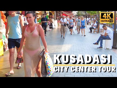
Kuşadası City Center Walking Tour | July 2022 Turkey [4K UHD 60 fps]
 0:02:59
Kusadasi in 4K Turkey | Türkiye
 0:39:06
Kuşadası, Aydın Walking Tour | April 2022 Turkey [4K UHD]
 0:00:32
Amazing Türkiye Kusadasi (4K) DJI Mini 3 PRO
 0:27:47
Kuşadası Winter Walk l February 2022 Aydın, Turkey [4K UHD]
 0:28:16
Kuşadası, Turkey - Virtual Walking Tour around the City - December 2021 [4K UHD]
 0:03:45
Turkey Travel Series Trailer (4K) | VLOG | Istanbul | Kusadasi | Ephesus | Cappadoccia | Antalya
 0:04:46
KUŞADASI AYDIN TURKEY | ATATURK HILL KUSADASI | 4k UHD 60fps
 0:02:09
Kusadasi - Guvercinada in winter by drone 4K - Turkey, January 2023
 0:03:26
Kuşadası from the sky - Turkey 2021 4K
 0:05:58
Turkey Aydın-(Kuşadası) Promotional 4K Ultra HD Video
 0:34:04
Walk in Kuşadası City Center l 29 August 2021 Turkey [4K UHD]
 0:20:21
Kusadasi, Turkey, September 2021 | 4K
Комментарии