filmov
tv
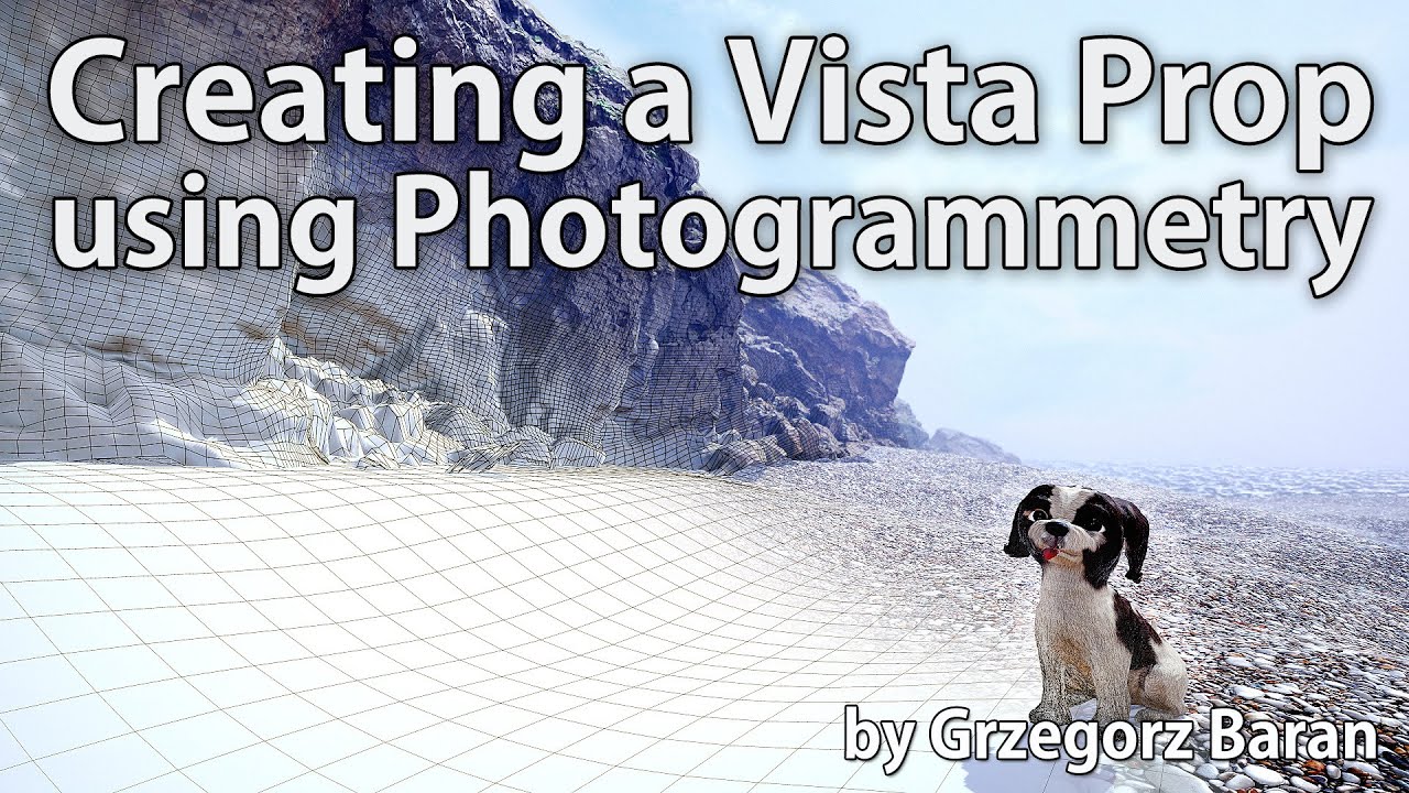
Environment Art - Turning a Cliff into a vista prop using photogrammetry
Показать описание
#photogrammetry #scanning #drone #pbr #workflow #environmentArt
In this video I present a full photogrammetry workflow where I captured a cliff rock fromation and turned it into a vista prop using photogrammetry.
In details I am going to show:
- cliff rock formation capture with the Mavic 2 Pro drone
- an image postprocessing with a different to usual way for ambient shadow removal in PhotoLab 3
- a full 3D reconstruction in Agisoft Metashape using new reconstruction mode
- I will build a new low poly topology in ZBrush
- which I am going to UV map with the RizomUV
- I will bake textures with the Substance Designer
- next I am going to cover missing and fix broken areas in Substance Painter
- and finally I am going to compose a quick scene in Marmoset Toolbag to present the result
You can find this video with resources used in this video on my gumroad:
I hope someone finds this video interesting and fun to watch
If you like it and want to see even more like this one, please subsribe to my channel and leave the thumbs up.
Big thanks for your support,
Cheers!
Grzegorz Baran
 0:40:27
Environment Art - Turning a Cliff into a vista prop using photogrammetry
 0:00:42
Artist Turns Puddles Into Stunning Art Around the World
 0:00:14
Thomas Deininger: Turning Trash Into Masterpieces | Contemporary Artist & Environmental Visionar...
 0:03:28
The Turning Point
 0:01:08
Environmental art show in El Paso turns trash to treasure
 0:02:18
Artist turns trash into craft, helping environment
 0:01:55
Turning trash into art
 0:00:15
Turning plastic bottles into #art | #upcycled plastics| #recycled plastics sculpture #shorts
 0:00:16
Nigerian artist turns old flip-flops into mosaic face portraits
 0:00:25
This Artist Turns Trash Into Art
 0:00:58
Turning a Drinking Glass Into a Mini Ecosystem!
 0:02:09
Artist turns clutter into eco-friendly accessories | Make Your Day
 0:02:26
This Woman Turns Fallen Leaves Into Stunning Works Of Art
 0:00:13
Turning Soil into Art: Creating Iconic Characters with Earthy Materials!
 0:03:04
Toxic Art: Turning Pollution into Paint with John Sabraw
 0:00:57
Venezuela: turning plastic waste into art to curb environmental pollution
 0:01:31
Artist turns home into 'bubble' so immunocompromised kids can create
 0:08:10
Wonderful Craft Artist turns Trash into Recycled Art
 0:12:57
The Salvaged Project - Turning Marine Debris into Art
 0:00:13
Turning the Place Over by Richard Wilson.
 0:03:15
Israeli Artist Turns Plastic Pollution into Giant Earth Installation
 0:00:34
Turning environments into umbrellas ☂ #aliens #art #environment #shorts
 0:00:25
Turning a Walk into a Fairytale Forest Adventure! #art #painting #acrylicpainting #tree
 0:00:43
Turning Waste Into Art! #shorts
Комментарии