filmov
tv
Metadata (Review from Fundamentals of GIS) - Geospatial Analysis Project

Показать описание
Link to this course:
Metadata (Review from Fundamentals of GIS) - Geospatial Analysis Project
Geographic Information Systems (GIS) Specialization
In this project-based course, you will design and execute a complete GIS-based analysis – from identifying a concept, question or issue you wish to develop, all the way to final data products and maps that you can add to your portfolio. Your completed project will demonstrate your mastery of the content in the GIS Specialization and is broken up into four phases:
Milestone 1: Project Proposal - Conceptualize and design your project in the abstract, and write a short proposal that includes the project description, expected data needs, timeline, and how you expect to complete it.
Milestone 2: Workflow Design - Develop the analysis workflow for your project, which will typically involve creating at least one core algorithm for processing your data. The model need not be complex or complicated, but it should allow you to analyze spatial data for a new output or to create a new analytical map of some type.
Milestone 3: Data Analysis – Obtain and preprocess data, run it through your models or other workflows in order to get your rough data products, and begin creating your final map products and/or analysis.
Milestone 4: Web and Print Map Creation – Complete your project by submitting usable and attractive maps and your data and algorithm for peer review and feedback.
Geographic Information System (GIS), Data Analysis, Project, Map Analysis, Project Management
Excellent course, I really liked pursuing the project of my choice and facing and demolishing all the challenges I faced on my way to the completion of the project.,Great class, helpful professor and admin! Definitely scratched the core of arcGIS, and will be doing more analysis in the future!
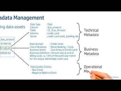
In this module, you will continue to work through Milestone 3, analyzing your data as outlined in the fourth week. Pay close attention to data quality issues and your metadata, as reviewed in this week's videos. You will have one more week to complete your data analysis.
Metadata (Review from Fundamentals of GIS) - Geospatial Analysis Project
Copyright Disclaimer under Section 107 of the copyright act 1976, allowance is made for fair use for purposes such as criticism, comment, news reporting, scholarship, and research. Fair use is a use permitted by copyright statute that might otherwise be infringing. Non-profit, educational or personal use tips the balance in favour of fair use.
Metadata (Review from Fundamentals of GIS) - Geospatial Analysis Project
Geographic Information Systems (GIS) Specialization
In this project-based course, you will design and execute a complete GIS-based analysis – from identifying a concept, question or issue you wish to develop, all the way to final data products and maps that you can add to your portfolio. Your completed project will demonstrate your mastery of the content in the GIS Specialization and is broken up into four phases:
Milestone 1: Project Proposal - Conceptualize and design your project in the abstract, and write a short proposal that includes the project description, expected data needs, timeline, and how you expect to complete it.
Milestone 2: Workflow Design - Develop the analysis workflow for your project, which will typically involve creating at least one core algorithm for processing your data. The model need not be complex or complicated, but it should allow you to analyze spatial data for a new output or to create a new analytical map of some type.
Milestone 3: Data Analysis – Obtain and preprocess data, run it through your models or other workflows in order to get your rough data products, and begin creating your final map products and/or analysis.
Milestone 4: Web and Print Map Creation – Complete your project by submitting usable and attractive maps and your data and algorithm for peer review and feedback.
Geographic Information System (GIS), Data Analysis, Project, Map Analysis, Project Management
Excellent course, I really liked pursuing the project of my choice and facing and demolishing all the challenges I faced on my way to the completion of the project.,Great class, helpful professor and admin! Definitely scratched the core of arcGIS, and will be doing more analysis in the future!
In this module, you will continue to work through Milestone 3, analyzing your data as outlined in the fourth week. Pay close attention to data quality issues and your metadata, as reviewed in this week's videos. You will have one more week to complete your data analysis.
Metadata (Review from Fundamentals of GIS) - Geospatial Analysis Project
Copyright Disclaimer under Section 107 of the copyright act 1976, allowance is made for fair use for purposes such as criticism, comment, news reporting, scholarship, and research. Fair use is a use permitted by copyright statute that might otherwise be infringing. Non-profit, educational or personal use tips the balance in favour of fair use.
 0:07:14
 1:00:41
 0:05:02
 0:08:12
 0:05:22
 1:43:58
 0:52:11
 0:10:05
 1:00:31
 1:00:25
 0:25:13
 0:05:22
 0:04:07
 0:53:32
 0:03:42
 0:05:55
 0:05:05
 0:06:28
 0:05:12
 0:32:26
 0:06:09
 1:30:36
 0:08:59
 0:48:23