filmov
tv
GIS For Beginners: Digitizing using Quantum QGIS

Показать описание
So, you are comfortable enough with Quantum GIS to open a GIS map and do some simple things like zooming in and out, and dragging your map around. You are now ready to try your own GIS project. But, you have a problem, because the GIS maps you need for your project are not available off-the-shelf.
This means that you are going to have to create your own GIS maps. Most likely, these will be old paper maps, or maps that you have created yourself. But, how will you go about bringing these maps into Quantum GIS? It is a process called digitizing, and digitizing a paper map using equipment that every office has is what this new Udemy Course is about.
I show you…
Step 1: How to scan your paper map so that you’re best placed for steps 2 thru 6.
Step 2: How to geo-reference the map you just scanned (put your scan into GIS coordinates) so you can use it as a backdrop for your digitizing.
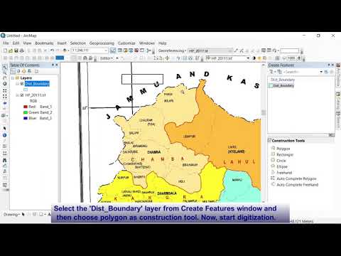
Step 3: How to create a blank GIS map to digitize into.
Step 4: How to create a donut polygon that will give you a crisp professional looking border for your map.
Step 5: How to set up your digitizing environment so that lines you digitize automatically join with neighboring lines
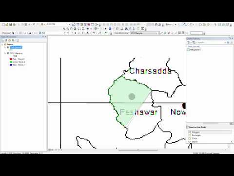
Step 6: How to on-screen digitize your GIS map using the now geo-referenced scanned map as a backdrop
You get to eavesdrop as I work, and gain insight into dealing with Digitizing Problems that would otherwise take you hours to troubleshoot.
If you enjoyed this video then check out these resources...
===== BELOW: Links To Coupons For My Udemy QGIS Tutorials and FREE QGIS Tutorial Series Not Available On YouTube ====
Enrol in ANY of my four QGIS for Beginners online HD video qgis tutorials on the Udemy teaching platform. All are Step-by-Step Follow-Along style and include companion eBooks and practice datasets..
* GIS for Beginners #1: QGIS Orientation +Free eBook (HIGHEST RATED QGIS TUTORIAL ON UDEMY)
* GIS for Beginners#2: Digitizing and Georeferencing in QGIS
* GIS for Beginners #4: Learn Geocoding in QGIS 3
* GIS for Beginners #5: Introduction to the QGIS Layout - Learn to present maps for presentations, theses and reports.
Join over 8000 other students.
* Introduction to QGIS (+free eBook)
* Traps with maps (+free eBook)
* Geocoding (+free eBook & practice dataset)
* Digitizing (+free eBook & practice dataset)
* Shading maps (+free eBook & practice dataset)
This means that you are going to have to create your own GIS maps. Most likely, these will be old paper maps, or maps that you have created yourself. But, how will you go about bringing these maps into Quantum GIS? It is a process called digitizing, and digitizing a paper map using equipment that every office has is what this new Udemy Course is about.
I show you…
Step 1: How to scan your paper map so that you’re best placed for steps 2 thru 6.
Step 2: How to geo-reference the map you just scanned (put your scan into GIS coordinates) so you can use it as a backdrop for your digitizing.
Step 3: How to create a blank GIS map to digitize into.
Step 4: How to create a donut polygon that will give you a crisp professional looking border for your map.
Step 5: How to set up your digitizing environment so that lines you digitize automatically join with neighboring lines
Step 6: How to on-screen digitize your GIS map using the now geo-referenced scanned map as a backdrop
You get to eavesdrop as I work, and gain insight into dealing with Digitizing Problems that would otherwise take you hours to troubleshoot.
If you enjoyed this video then check out these resources...
===== BELOW: Links To Coupons For My Udemy QGIS Tutorials and FREE QGIS Tutorial Series Not Available On YouTube ====
Enrol in ANY of my four QGIS for Beginners online HD video qgis tutorials on the Udemy teaching platform. All are Step-by-Step Follow-Along style and include companion eBooks and practice datasets..
* GIS for Beginners #1: QGIS Orientation +Free eBook (HIGHEST RATED QGIS TUTORIAL ON UDEMY)
* GIS for Beginners#2: Digitizing and Georeferencing in QGIS
* GIS for Beginners #4: Learn Geocoding in QGIS 3
* GIS for Beginners #5: Introduction to the QGIS Layout - Learn to present maps for presentations, theses and reports.
Join over 8000 other students.
* Introduction to QGIS (+free eBook)
* Traps with maps (+free eBook)
* Geocoding (+free eBook & practice dataset)
* Digitizing (+free eBook & practice dataset)
* Shading maps (+free eBook & practice dataset)
 0:03:05
 0:10:38
 0:16:23
 0:10:33
 0:18:02
 0:10:30
 0:07:21
 0:21:35
 0:16:01
 0:09:39
 0:10:25
 0:04:18
 1:24:42
 0:11:49
 0:04:49
 0:09:10
 0:09:49
 1:12:46
 0:11:00
 0:03:48
 1:10:08
 0:11:16
 0:18:35
 0:19:13