filmov
tv
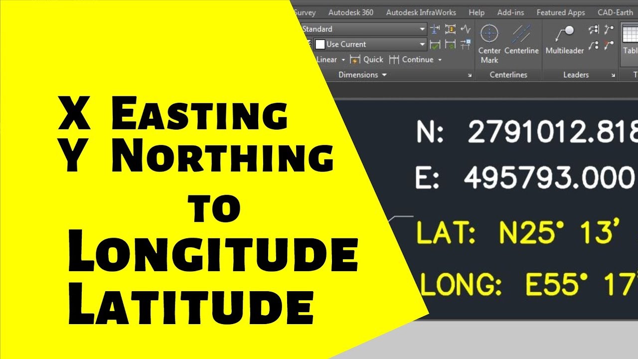
Convert AutoCAD Coordinates to Latitude and Longitude - N E to Lat Long - XY to Lat Long - UTM
Показать описание
Convert AutoCAD Coordinates to Latitude and Longitude - N E to Lat Long - XY to Lat Long - UTM to Lat Long
For more read here
Download the Excel file to calculate coordinates.
Formulas to calculate coordinates.
In this video tutorial learn how to convert easting northing coordinates to longitude and latitude.
convert AutoCAD coordinates to latitude and longitude
convert AutoCAD coordinates to latitude and longitude - N E to Lat Long - convert XY to lat long
#Convert #AutoCAD #CoordinatestoLatitudeLongitude - #NE to #Lat #Long - #XY to #LatLong - #UTMtolatlong
In this video tutorial learn how to convert easting northing coordinates to longitude and latitude.
My Gadgets:
Desktop - i7
Monitor - 21.5 Inch
Mouse
Laptop
Headphones
Microphone
Watch I am using
Mobile Phone
UTM to Latitude and Longitude Converter
e n to lat long
how to draw latitude and longitude in AutoCAD
how to convert latitude and longitude to northing and easting in AutoCAD
civil 3d lat long points
civil 3d import lat long points
convert xy to lat long online
convert northing easting to lat long
how to get latitude and longitude in civil 3d
easting northing to lat long
convert easting northing to lat long excel
convert northing easting to lat long formula
northing easting to lat long converter excel
UTM to lat long converter
convert UTM to lat-long online
how to calculate northing and easting coordinates
batch convert UTM to lat-long
easting northing google maps
Latitude and Longitude to Northing-Easting Conversion
How do you find latitude and longitude in Civil 3d?
How do you enter latitude and longitude in Autocad?
How do I label coordinates in Autocad?
How to convert N/E to Lat/Long in Civil3D
convert Easting, Northing to Latitude, Longitude by civil 3d
Civil3D Convert to Lat Long
lat long to UTM, latitude longitude to UTM, coordinate conversion, wgs 1984 to UTM, geographic to cartesian, lat long to easting northing, by qgis software, qgis tutorial, lat-long, easting northing, importing data in qgis, convert to easting northing, qgis (software)
 0:05:41
Convert AutoCAD Coordinates to Latitude and Longitude - N E to Lat Long - XY to Lat Long - UTM
 0:05:07
How to create a point in Civil3d using latitude and longitude input
 0:08:58
Convert UTM to Decimal Degrees /Latitude Longitude with Excel
 0:02:38
Convert UTM to Latitude & Longitude | Convert UTM to Decimal Degrees in Excel | Excel For Engine...
 0:01:08
How to insert site coordinates in autocad quickly | Easting and Northing
 0:05:06
AutoCAD Civil 3D Coordinate Conversion
 0:01:19
Find Latitude and Longitude in AutoCAD
 0:11:05
How to convert coordinates between 2 different zones ( QND to WGS84 )
 0:02:29
How to convert UTM Coordinate To Latitude And Longitude
 0:09:37
How to Convert Local Coordinate Drawings to UTM and KML, KMZ AutoCAD, and Civil 3D
 0:01:06
Civil 3D Points Latitude and Longitude to Degrees
 0:11:06
Convert WGS84 to UTM | how to convert coordinate from autocad and google | convert UTM to WGS84 |
 0:00:22
Change Coordinate Format In Google Earth
 0:07:34
Convert UTM Coordinates to Latitude Longitude | ENZ to Latitude & Longitude in Global Mapper
 0:07:15
How to convert Latitude/Longitude Coordinates to Grid Coordinates| Plane to Grid| Ge survey tutorial
 0:09:35
How to take Coordinates from Google Earth & use them in to Auto CAD
 0:01:49
AutoCAD How To Find Coordinates Tutorial
 0:02:45
How to Convert UTM Coordinates to Latitude and Longitude2023.Step by Step Tutorial.
 0:02:33
Convertisseur de coordonnées en ligne
 0:01:14
UTM to Latitude Longitude Converter v1.0
 0:13:16
Convert Coordinate From Lat-Long To UTM & UTM To Lat-Long I Coordinate Convert Kaise Kare Agrag...
 0:10:54
World coordinates converter . convert coordinates between 2 different system WGS84 UTM WGS 83 QNHD
 0:02:44
Locating Latitude and Longitude with Civil 3D
 0:04:12
How to Set Geo Location in AutoCad?
Комментарии