filmov
tv
Calculating Distance between two sets of geographic coordinates using only zip codes or cities
Показать описание
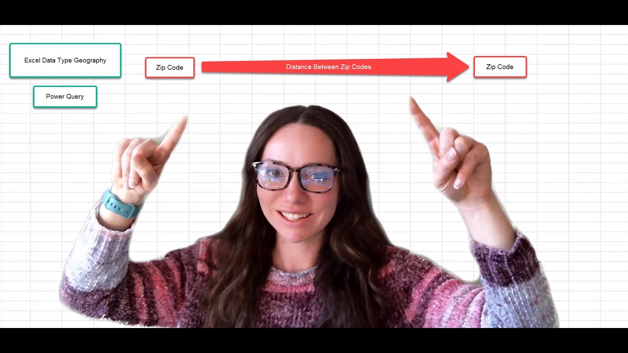
This video used Excel data type Geography and Power Query to find the difference between 2 sets of coordinates. Using only zip codes, you can extract Lat and Long using Excel data types; these tables are then loaded into a power query to find the distance between points.
Power Query M Formula for Distance in Miles (Replace all the Bold with your column names):
Number.Acos(Number.Cos((90-[Latitude])*Number.PI/180)*Number.Cos((90-[Leads.Latitude])*Number.PI/180)
+ Number.Sin((90-[Latitude])*Number.PI/180)*Number.Sin((90-[Leads.Latitude])*Number.PI/180)*Number.Cos(([Longitude]-[Leads.Longitude])*Number.PI/180)) * 3959
 0:13:17
Calculating Distance between two sets of geographic coordinates using only zip codes or cities
 0:04:20
Calculate the distance between two sets of latitude and longitude coordinates
 0:10:38
What is the distance between two sets of points? | Hausdorff Distance
 0:12:41
How to Determine the Distance Between Geographic Coordinates?
 0:06:21
Find Distance Between 2 COORDINATES | Find Distance Between Coordinates in Excel
 0:04:07
Calculating Distance In Excel
 0:04:36
How to Find the Distance Between Two Points - How to Use the Distance Formula
 0:01:47
5.3 How to calculate the distance between 2 locations? [Reporting on maps in Excel & Power BI]
 0:32:03
Measure Theoretic Probability: Lesson 22
 0:05:50
Distance Calculator in Excel | Calculate Distance Between Two Cities | Custom Functions with LAMBDA
 0:04:21
Applying the distance formula to find the distance between two points
 0:00:18
AutoCAD - how to measure Distance between two points in AUTOCAD | learn autocad free
 0:06:16
How to find Euclidean Manhattan Minkowski distance Supremum distance Cosine Similarity Mahesh Huddar
 0:00:29
CASIO 991EX - Shortcut in solving Distance between two points.
 0:13:46
Excel - Calculate the Distance Between Two Locations and Show on a Map
 0:05:55
Geography mapwork: How to calculate distance on the map
 0:03:24
How to get even spacing / Equal distance / Calculate distance
 0:04:59
Tableau Calculations : Distance Between 2 Points
 0:11:20
How To Calculate Distance Based On Coordinates Using Python | Most Easy Method | AISciences.io
 0:03:40
Example finding distance with Pythagorean theorem
 0:07:12
Google Maps | Calculate Distance Between 2 Locations (Android Tutorials)
 0:07:05
How to Compute De, D4 City Block Distance, D8 Chess Board distance, and Dm distance by Mahesh Huddar
 0:09:56
14. Distance between Sets | Metric Space | Prof Khalid
 0:33:39
Lecture 17 - Distance between Fuzzy Sets By Prof. Nishchal K.Verma
Комментарии