filmov
tv
GeoPython 2024 Workshop: Spatial Data Science with Python

Показать описание
Sergio Rey, Levi John Wolf
Spatial Data Science with Python
2024-05-27, 16:50–18:50, Room 1
This workshop provides a hands-on tutorial focused on spatial analysis and spatial data science with Python. It introduces the Python Spatial Analysis Library (PySAL), providing a foundation for geographic data science for applied analyses of urban socio-spatial structure.
PySAL Overview
Brief introduction to the PySAL ecosystem of packages for spatial data science
Spatial data processing
Reading and writing GIS file formats, spatial data wrangling, changing coordinate transformation systems.
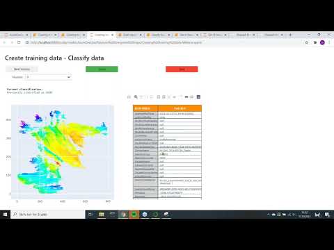
Choropleth mapping and geovisualization
Introduction to choropleth map classification using mapclassify. Basic visualization with GeoPandas, and matplotlib as well as interactive visualization via folium, leaflet and geoviews/hvplot,
Hands-on 1 Exploratory Geovisualization
Spatial weights
Introduction to the spatial weights matrix for formally encoding geographic relationships.
Global & Local spatial autocorrelation
Exploratory spatial data analysis and overview of measures of spatial autocorrelation statistics such as Moran's I and the join-count statistic.
Hands-on 2 Hot-spot detection
Spatial Data Science with Python
2024-05-27, 16:50–18:50, Room 1
This workshop provides a hands-on tutorial focused on spatial analysis and spatial data science with Python. It introduces the Python Spatial Analysis Library (PySAL), providing a foundation for geographic data science for applied analyses of urban socio-spatial structure.
PySAL Overview
Brief introduction to the PySAL ecosystem of packages for spatial data science
Spatial data processing
Reading and writing GIS file formats, spatial data wrangling, changing coordinate transformation systems.
Choropleth mapping and geovisualization
Introduction to choropleth map classification using mapclassify. Basic visualization with GeoPandas, and matplotlib as well as interactive visualization via folium, leaflet and geoviews/hvplot,
Hands-on 1 Exploratory Geovisualization
Spatial weights
Introduction to the spatial weights matrix for formally encoding geographic relationships.
Global & Local spatial autocorrelation
Exploratory spatial data analysis and overview of measures of spatial autocorrelation statistics such as Moran's I and the join-count statistic.
Hands-on 2 Hot-spot detection
 1:36:07
 2:03:35
 1:36:07
 1:40:16
 1:12:01
 0:00:55
 0:22:51
 0:29:35
 0:10:41
 0:00:47
 0:00:56
 0:48:36
 1:31:07
 0:46:14
 0:45:55
 0:53:39
 0:17:11