filmov
tv
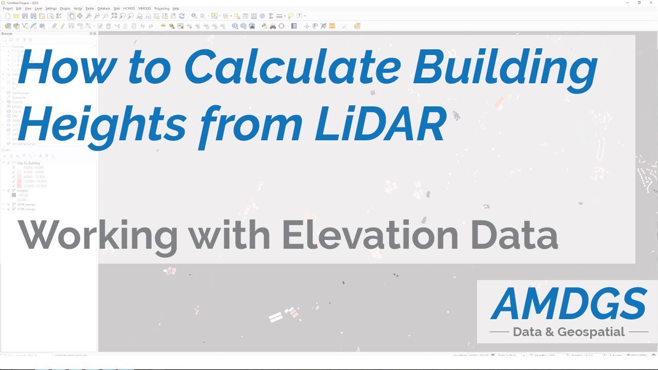
Calculating Building Heights From LiDAR Data (or any heights from DSM & DTM)
Показать описание
This quick tutorial talks you through how to calculate building heights from LiDAR elevation data, taking advantage of the digital terrain model (DTM) and digital surface model (DSM), along with zonal statistics tools.
This is a really useful way of adding height values to any vector features, which can later be used to assist with 3D visualisation.
If you found this video useful, please remember to like and subscribe!
This is a really useful way of adding height values to any vector features, which can later be used to assist with 3D visualisation.
If you found this video useful, please remember to like and subscribe!
 0:06:50
Calculating Building Heights From LiDAR Data (or any heights from DSM & DTM)
 0:15:43
Building Heights: From Open USGS lidar to open Overture maps – Yunzhi Lin & Eric Spellman
 0:01:27
GIS: Calculating canopy height in ArcGIS Desktop without LiDAR data? (2 Solutions!!)
 0:04:26
Measuring LiDAR Data in ArcGIS Pro
 0:01:48
GIS: Calculate volume of a building using LiDAR data
 0:08:37
How to Use Lidar Features: Automated Pole Classification and Extraction
 0:07:23
RS.Lab3 - Processing Lidar data
 0:21:01
Lidar Feature Extraction - Buildings
 0:00:31
Lidar Point Cloud - Building Classification
 0:13:57
ArcGIS Pro: Create 3D Buildings from LiDAR
 0:03:36
Measuring height of plants and trees through LiDAR
 0:01:03
Mapping with LiDAR
 0:44:14
LiDAR Building Extraction Tool Tutorial (Full Video)
 0:19:47
Canopy Height Measurement using Spaceborne LiDAR
 0:01:01
Simple 3D model of Seattle using building footprints and two Lidar datasets
 1:00:00
Processing LiDAR Data to extract 3D Buildings, extract Roof Forms & to classify Power Lines
 0:24:07
Best Practices for Working with LiDAR
 0:41:34
Headwall LiDAR Tools Tutorial with Examples of LAS DEM HSI-LiDAR Fusion
 0:05:00
How-to: Extracting Building Footprints using Esri's Deep Learning Model
 0:08:53
Extract Building Footprints from LIDAR or Photogrammetric Point Clouds Data Using ArcGIS Pro
 0:59:03
Preparing LiDAR for Use in ArcGIS 10.1 with the Data Interoperability Extension
 0:06:53
Elon Musk says losers use LiDAR. [Explanation video]
 0:01:25
Road Scene Module | 6.Add Building Layer LiDAR Software Tutorial
 0:14:06
Locating forest interior habitat using LiDAR-derived canopy height model
Комментарии