filmov
tv
WebGIS application development using Openlayers 6 and Geoserver-part2 (Featureinfo and Measure Tool)

Показать описание
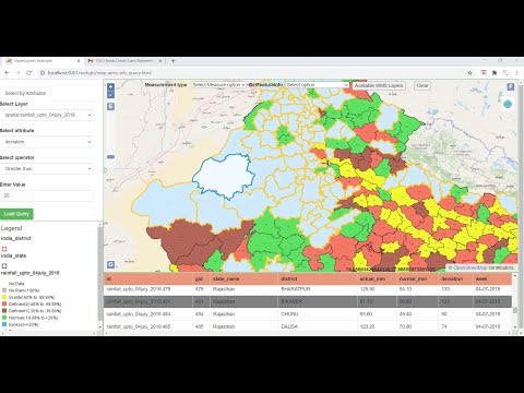
This video shows how to add getfeatureinfo and measurement tool in a simple Web GIS application using Geoserver, and latest Openlayers version 6
Link for the web GIS application html page:
Link for the jquery js file:
Link for downloading Openlayers 6:
Link for downloading layerswitcher
Link for video showing how to install geoserver with tomcat:
Link for video showing how to Install postgresql with postgis extension and import/export shapefiles from the postgis database
How to Publish shapefiles/raster images using GeoServer
 0:17:57
WebGIS application development using Openlayers 6 and Geoserver - part1
 0:02:52
Mastering OpenLayers - Become a successful WebGIS developer
 0:27:01
WebGIS development using Node.js and Openlayers
 0:24:09
WebGIS app development using Openlayers-6 & Geoserver-Pt3 (Query panel using WMS & WFS servi...
 0:35:30
Enterprise GIS Portal Developed Using PostgreSQL PostGIS, OpenaLayers, GeoServer
 0:16:31
WebGIS application development using Openlayers 6 and Geoserver-part2 (Featureinfo and Measure Tool)
 0:13:22
Developing your First Web Mapping Application.
 1:37:08
COVID WebGIS development from scratch using openlayers, Postgis & JSP (without Geoserver)
 0:06:11
Webgis development using node js and openlayers
 0:40:39
Geoserver: Publish and style raster data in geoserver for WebGIS application using Openlayers 6
 0:18:42
WebGIS Application development (feature editing on web)using Geoserver, Openlayers, GeoExt, Postgis
 3:31:51
Building Land surveying app using Openlayers + PostGIS + Geoserver + PHP/AJAX from scratch
 0:52:00
Geoserver: Feature Editing on WebGIS using Geoserver(WFS-T service) and Openlayers
 0:07:59
Adding Home and Full Screen control to your Web Mapping Application in OpenLayers
 0:10:07
Simple Web Map for Openlayers using Html and JavaScript.
 0:02:52
Mastering OpenLayers - Course on Udemy
 0:10:20
Layer Switcher in OpenLayers Web Mapping Application
 0:30:31
#openlayers #webgis GIS with openlayers part4. Add attribute table from GeoJSON
 0:10:03
47_1: Java Web GIS and Mapping programming | OpenLayers | Leaflet | GeoServer | Maps JS libraries
 0:35:22
Geoserver for WebGIS development (WMS, WFS, WFS-T Service), Feature editing on web.
 0:01:39
WebGIS (OpenLayer, GeoDjango)
 0:18:20
WebGIS development Add Query panel (Feature query Tool) to WebGIS page - part 3
 0:23:18
#openlayers #webgis GIS with openlayers part5. Add Style icon on openlayers map
 0:08:39
Web mapping applications using GeoExt, ExtJS, OpenLayers and GeoJSON
Комментарии