filmov
tv
What is Remote Sensing and GIS?

Показать описание
"Remote Sensing vs GIS" is something that everyone in the spatial science realm had pondered about at some point in their life. And it was nothing different for me when I started a couple of years back. Hence, as I am restarting this channel, I want to provide a brief introduction on what is remote sensing and GIS - and their major types, applications and a few key terms (such as active and passive remote sensing, shapefile, raster and vector data, ArcMap, GIS mapping, etc.). Even though there are a lot of similarities, they are both entirely different science streams (more like sister departments).
Understanding GIS and Remote Sensing will help you figure out the right technologies and approach you will have to adopt for solving your specific research questions - and, who knows, maybe even encourage you to consider any of these areas as a potential career path.
------------------ Contents of the Video ------------------
0:00 - Intro
1:30 - What is Remote Sensing
3:53 - Sensor Platforms and LiDAR
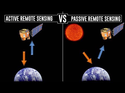
4:59 - Active and Passive Remote Sensing
6:19 - Types of Remote Sensing
7:57 - Example Applications
8:54 - Issue with Excessive Data
10:00 - What is Geographic Information Systems (GIS)
12:03 - Data Collection, Management and Analysis
14:20 - Key Terms related to GIS
-------------------------------------------------------------------------
Hope you guys find this video useful. Leave me a comment if anything is unclear or if you would like me to go in-depth on any of the specifics. Thanks for watching! - Mikey
Understanding GIS and Remote Sensing will help you figure out the right technologies and approach you will have to adopt for solving your specific research questions - and, who knows, maybe even encourage you to consider any of these areas as a potential career path.
------------------ Contents of the Video ------------------
0:00 - Intro
1:30 - What is Remote Sensing
3:53 - Sensor Platforms and LiDAR
4:59 - Active and Passive Remote Sensing
6:19 - Types of Remote Sensing
7:57 - Example Applications
8:54 - Issue with Excessive Data
10:00 - What is Geographic Information Systems (GIS)
12:03 - Data Collection, Management and Analysis
14:20 - Key Terms related to GIS
-------------------------------------------------------------------------
Hope you guys find this video useful. Leave me a comment if anything is unclear or if you would like me to go in-depth on any of the specifics. Thanks for watching! - Mikey
 0:03:27
What is Remote Sensing? Understanding Remote Sensing
 0:02:42
What is Remote Sensing?
 0:18:46
What is Remote Sensing and GIS?
 0:02:52
What is Active and Passive Remote Sensing?
 0:04:28
What is the Process of Remote Sensing?
 0:01:04
What is Remote Sensing?
 0:27:38
Geog136 Lecture 11.1 Remote sensing basics
 0:17:20
What is remote sensing?? || Introduction to remote Sensing
 0:39:16
Remote Sensing and GIS
 0:01:39
Remote Sensing Scientists, Technologists, and Technicians Career Video
 0:04:06
What is Remote sensing?
 0:02:35
ArcGIS Imagery & Remote Sensing
 0:02:08
MSc Program 'Remote Sensing and Geoinformatics' at KIT
 0:01:47
How AI is Transforming Remote Sensing Applications
 0:04:31
Top 3 Geospatial Technologies: GIS, Remote Sensing, and GPS
 0:02:01
What is Spatial Resolution in Remote Sensing?
 0:11:32
Introduction to Remote Sensing Definition Lecture 01
 1:21:03
1. Introduction to Remote Sensing
 0:07:45
How Does LiDAR Remote Sensing Work? Light Detection and Ranging
 0:02:01
Applications of Remote Sensing in Precision Farming
 0:05:51
Mapping the Invisible: Introduction to Spectral Remote Sensing
 0:07:31
Remote Sensing and Climate Change | Geoscience and Remote Sensing Society (GRSS)
 0:01:14
REmote sensing
 0:15:45
Active vs. Passive Remote Sensing - What is Remote Sensing? (2/10)
Комментарии