filmov
tv
Assignment 2 using GRASS GIS

Показать описание
The tasks are to determine the:
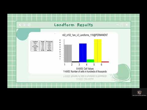
1. landscape (for example: peaks, saddle, pits, ridges, plains) and
2. change of NDVI over time (at least 5 data points, preferably different years) of the Tampin region using GRASS GIS.
1. landscape (for example: peaks, saddle, pits, ridges, plains) and
2. change of NDVI over time (at least 5 data points, preferably different years) of the Tampin region using GRASS GIS.
 0:09:24
 0:06:39
 0:09:46
 0:06:43
 0:18:20
 0:23:14
 0:03:46
 0:01:52
 0:00:20
 0:06:49
 0:01:23
 0:00:14
 0:02:31
 0:02:00
 0:04:14
 0:06:47
 0:11:37
 0:16:37
 0:20:26
 0:07:56
 0:03:31
 0:09:24
 0:02:13
 0:24:12