filmov
tv
Tutorial: Introduction to the command line interface

Показать описание
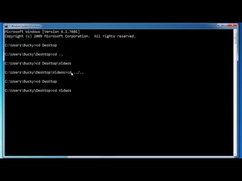
This video is part of the open course Programming for Geospatial Hydrological Applications. In this video you learn how to use the command line interface using a DOS emulator. You can use the same commands on the Windows Command Prompt.
In the course you'll learn an essential skill for researchers dealing with (spatial) data. With scripting you can better control your analysis using command line tools. You can also automate your procedures by writing batch scripts. Furthermore, you can process your data and make models using Python and its useful libraries.
The online learning course on Programming for Geospatial Hydrological Applications is part of the Climate Services for Water Management (CliMWaR) project, funded by the Flemish UNESCO Science Trust Fund (FUST) from the Government of Flanders in Belgium.
#GISOCW #IHEDelft
 0:07:31
Windows Command Line Tutorial - 1 - Introduction to the Command Prompt
 0:20:46
Tutorial: Introduction to the command line interface
 0:13:51
How to use the Command Line | Terminal Basics for Beginners
 0:44:53
Command Line Crash Course For Beginners | Terminal Commands
 0:07:58
Linux Command Line Tutorial For Beginners 1 - Introduction
 0:05:18
Windows Command Line Tutorial #1 - Einleitung
 0:08:11
Basic CMD Commands for Windows 10 | Command Prompt Tutorial for Beginners
 5:00:17
The 50 Most Popular Linux & Terminal Commands - Full Course for Beginners
 0:09:02
How to use scores, tags, hasitem, and locations - Minecraft Bedrock Commands Tutorial Series
 0:05:16
Linux Tutorial: 34 Introduction to the Find command
 0:15:23
Windows PowerShell/Command Line for Beginners (Tutorial)
 0:25:59
Command Line Interface (CLI) For Beginners
 0:09:55
A Designer's Introduction to the Command Line
 0:05:34
IT Networking Tutorial - Using The COMMAND LINE
 3:18:32
CMD - Command Prompt Training for IT Professionals (Full Course)
 0:13:11
How To Use Terminal On Your Mac - Command Line Beginner's Guide
 0:22:55
Beginner Introduction to The Sleuth Kit (command line)
 0:02:06
Command Line Basics #1 - Series Introduction
 0:16:49
Kali Linux Terminal / Command Line for Beginners (Tutorial)
 0:18:41
Command Prompt Basics: How to use CMD
 0:09:55
Linux Command Line Tutorial For Beginners 20 - Introduction to Bash Scripting
 0:17:31
Linux / Mac OS X Terminal Tutorial | Part 1 Introduction to command line
 2:47:56
Linux Operating System - Crash Course for Beginners
 0:18:06
Introduction to Tcl: The tool command language - Part 1
Комментарии