filmov
tv
HOW DO SPACECRAFT NAVIGATE THROUGH SPACE

Показать описание
Spacecraft navigate through space using a combination of onboard instruments, pre-programmed instructions, and real-time adjustments based on data received from Earth. Here are the key components and methods used in spacecraft navigation:
Inertial Measurement Units (IMUs):
IMUs include gyroscopes and accelerometers that measure the spacecraft's orientation and acceleration. By integrating these measurements, the spacecraft can determine its velocity and position over time.
Star Trackers:
Star trackers are optical devices that take images of the stars and compare them to a known star catalog. This helps the spacecraft determine its orientation in space (attitude determination).
Sun Sensors:
Sun sensors detect the position of the Sun, providing additional information about the spacecraft's orientation.
Radio Navigation:
Spacecraft use radio signals to communicate with Earth-based tracking stations. By analyzing the Doppler shift of these signals and their travel time, ground controllers can determine the spacecraft's velocity and distance from Earth (range and range rate).
Deep Space Network (DSN):
The DSN is a worldwide network of large antennas and communication facilities that support interplanetary spacecraft missions. It provides precise tracking and navigation data.
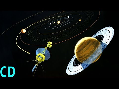
Celestial Navigation:
In deep space, spacecraft can use the positions of planets, moons, and other celestial bodies to determine their location and trajectory.
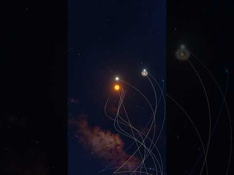
Gravitational Assists:
Spacecraft can perform flybys of planets and moons to use their gravitational pull to alter their trajectory and speed without using additional fuel.
Thrust Maneuvers:
Spacecraft are equipped with thrusters that can be fired to adjust their velocity and trajectory. These maneuvers are carefully calculated and executed based on navigation data.
Autonomous Navigation:
Inertial Measurement Units (IMUs):
IMUs include gyroscopes and accelerometers that measure the spacecraft's orientation and acceleration. By integrating these measurements, the spacecraft can determine its velocity and position over time.
Star Trackers:
Star trackers are optical devices that take images of the stars and compare them to a known star catalog. This helps the spacecraft determine its orientation in space (attitude determination).
Sun Sensors:
Sun sensors detect the position of the Sun, providing additional information about the spacecraft's orientation.
Radio Navigation:
Spacecraft use radio signals to communicate with Earth-based tracking stations. By analyzing the Doppler shift of these signals and their travel time, ground controllers can determine the spacecraft's velocity and distance from Earth (range and range rate).
Deep Space Network (DSN):
The DSN is a worldwide network of large antennas and communication facilities that support interplanetary spacecraft missions. It provides precise tracking and navigation data.
Celestial Navigation:
In deep space, spacecraft can use the positions of planets, moons, and other celestial bodies to determine their location and trajectory.
Gravitational Assists:
Spacecraft can perform flybys of planets and moons to use their gravitational pull to alter their trajectory and speed without using additional fuel.
Thrust Maneuvers:
Spacecraft are equipped with thrusters that can be fired to adjust their velocity and trajectory. These maneuvers are carefully calculated and executed based on navigation data.
Autonomous Navigation:
 0:16:58
 0:08:40
 0:02:29
 0:11:15
 0:03:43
 0:09:53
 0:04:40
 0:02:54
 0:15:45
 0:05:46
 0:02:58
 0:09:30
 0:17:12
 0:16:50
 0:01:00
 0:00:57
 0:08:50
 0:03:43
 0:00:43
 0:17:53
 0:02:56
 0:03:07
 0:35:19
 0:06:58