filmov
tv
NASA | Peeling Back Landsat's Layers of Data

Показать описание
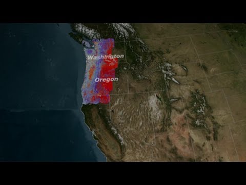
Landsat satellites circle the globe every 99 minutes, collecting data about the land surfaces passing underneath. After 16 days, the Landsat satellite has passed over every spot on the globe, and recorded data in 11 different wavelength regions. The individual wavelength bands can be combined into color images, with different combinations of the 11 bands revealing different information about the condition of the land cover.
The Landsat program is jointly managed by NASA and the USGS:
Like our videos? Subscribe to NASA's Goddard Shorts HD podcast:
Or find NASA Goddard Space Flight Center on Facebook:
Or find us on Twitter:
The Landsat program is jointly managed by NASA and the USGS:
Like our videos? Subscribe to NASA's Goddard Shorts HD podcast:
Or find NASA Goddard Space Flight Center on Facebook:
Or find us on Twitter:
 0:02:57
NASA | Peeling Back Landsat's Layers of Data
 0:07:36
NASA | Landsat's Global Perspective
 0:01:16
NASA | Landsat's Orbit
 1:28:04
Landsat Celebrates 40th Anniversary
 0:04:52
NASA / USGS | Landsat: A Space Age Water Gauge
 1:16:27
Know your Landsat: Understanding and Accessing Landsat Data
 0:03:11
NASA | Landsat Tracks Urban Change and Flood Risk
 0:02:15
Landsat Collections - RMSE
 0:03:34
NASA | Earth Observing Landsat 5 Turns 25 Years Old
 0:03:13
Landsat 9 Data Available!
 0:03:33
Celebrating 40 years of Landsat Satellites
 0:02:24
Landsat Science Products
 0:02:37
Anatomy of Landsat 8, USGS satellite
 0:02:19
Landsat Analysis Ready Data (ARD)
 0:00:45
Landsat 9 Underfly, November 2021
 0:47:53
Congressional Briefing: Fire, Food, and Water: 40 Years of Landsat Satellites
 0:02:22
Landsat Collections
 0:01:00
Preview: LDCM's Liftoff!
 0:03:45
NASA | Landsat Senses a Disturbance in the Forest
 0:01:03
Every Pixel - Landsat's Orbit
 0:04:41
A Planetary Perspective: With Landsat and Google Earth Engine
 0:01:38
Every Pixel - Landsat's Sensors
 0:06:12
LDCM: A New Era in Earth Observation
 0:05:11
Landsat 8 Bands
Комментарии