filmov
tv
Chartwork Tutorial: Datums, Depths & Heights
Показать описание
For more help and assistance learning marine navigation, as well as lots of informal discussion about creating maritime content on YouTube, why not consider joining our community on Patreon.
----------ABOUT THE VIDEO----------
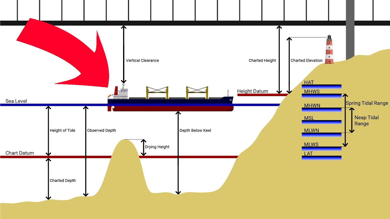
In this video, we take a look at how chart datum is used to reference depths on a nautical chart.
----------DISCLAIMER----------
This video should not be considered professional advice or education.
We try to make the content as accurate as possible, but the responsibility rests with the viewer to determine the full accuracy and reliability of the content.
Any action you take as a result of watching this video is strictly at your own risk.
----------ABOUT THE VIDEO----------
In this video, we take a look at how chart datum is used to reference depths on a nautical chart.
----------DISCLAIMER----------
This video should not be considered professional advice or education.
We try to make the content as accurate as possible, but the responsibility rests with the viewer to determine the full accuracy and reliability of the content.
Any action you take as a result of watching this video is strictly at your own risk.
 0:08:08
Chartwork Tutorial: Datums, Depths & Heights
 0:07:23
Charted Depths - Chartwork and Tides
 0:00:52
Chart Datum and Tide Heights: Your Essential Guide
 0:01:41
Reading the nautical charts depth note
 0:04:36
Chartwork Tutorial: Running Fix
 0:06:05
Chartwork Tutorial: How To Measure Distances On A Nautical Chart
 0:07:41
Ep 11: Navigation: Tide Tables
 0:03:00
Tidal Reference|MHWS|MLWS|MHWN|MLWN|HAT|LAT
 0:04:21
Tide heights tutorial
 0:11:46
Height of Tide Tutorial
 0:03:28
Tide heights - definitions of tidal levels
 0:08:10
Chartwork Tutorial: Compass Rose
 0:05:16
Chartwork Tutorial: Course To Steer
 0:00:31
Chart datum Meaning
 0:10:51
CHART DATUM 6A
 0:06:31
Day Skipper theory - Charts the magic of the maps
 0:02:04
How to Correct Your Depth Sounder to “Charted Depth”
 0:08:41
INTRO-NAUTICAL CHARTS|Projections|Datums & Soundings|Title Block CHARTWORK SERIES - NSA
 0:13:18
How & from where we measure Tide | Tidal Datum- Part 3
 0:06:15
Datum and Elevations in drilling rigs, mean sea level and RTKB.
 0:01:40
Tidal information on a chart plotter
 0:01:07
Reading the nautical charts depths and dangers
 0:03:05
RYA Day Skipper Tides Does the tide go below Chart Datum?
 0:05:59
Chartwork Tutorial: Nature Of Seabed
Комментарии