filmov
tv
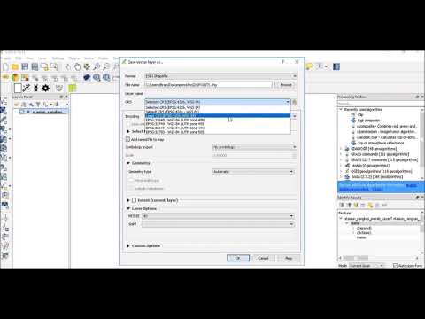
Import Shapefile in QGIS - Surface Water Flooding Depth Range

Показать описание
Learn how to import the surface water flooding depth range in QGIS.
Learning Outcomes:
- Import Shapefile in QGIS
- Stylize the Shapefile to show the flood depth range
- Set up a new Print Layout
- PDF from QGIS
Join the Civil Tech Source Community by becoming a member:
Download QIGS:
DEFRA Surface Water Flood Data:
Download CAD Site Boundary:
My Gear:
Timestamps
00:00 Intro
00:40 Prep your Site Boundary
01:10 Download Surface Water Data
02:10 Import Site Boundary
03:35 Load Satellite Image
03:55 Load Shapefile
04:30 Style Shapefile
06:05 Add Text
06:35 Copy Styles
07:05 Prepare your Layout to PDF
#surfacewaterflooding #floodanalysis #drainagedesign
 0:01:21
How to Import ShapeFiles in QGIS editor
 0:02:50
Import Shapefiles in QGIS || QGIS Basics Part 1 ||
 0:01:03
How to Add Shape (.SHP, .DXF) file in QGIS
 0:00:23
QGIS Import Esri Shapefile
 0:05:52
QGIS Create Shapefile || Shapefile Layer in QGIS
 0:04:21
QGIS Basics - Importing shape files and changing their CRS
 0:02:57
How to Extract Smaller Areas From A larger Shapefile in QGIS
 0:00:37
Converting GeoJSON (JSON) files to Shapefiles in QGIS
 0:04:42
QGIS Tutorials 11: Importing GPS Data & Convert to Shapefile using QGIS | QGIS Beginners | GPX f...
 0:01:42
QGIS - Union/Combine Shapefiles - Merge Vector Layers - Method I
 0:06:26
How to Add Excel file CSV with Shape file in QGIS 2021 ENGLISH
 0:02:07
Convert DWG Files of AutoCAD into Shapefile in QGIS
 0:01:50
Convert KML to Shape file in QGIS
 0:03:25
How to merge multiple ShapeFiles/Vector Layers into One ShapeFile Using QGIS Editor
 0:04:06
Getting World Shapefile and Selecting Individual Countries in QGIS
 0:03:58
Import ShapeFile into Unity Using QGIS
 0:08:50
How to download and import shapefile/vector GIS Data for any country – Free online sources
 0:03:07
KML / KMZ to SHP / Shapefile Conversion in QGIS
 0:06:57
Import Shapefile from QGIS into MySQL using WKT - Part 1
 0:05:14
Easy Steps to Convert KML to SHP (Shapefile) and Back in QGIS
 0:01:52
Qgis : Importer une couche shapefile
 0:03:31
How to convert DWG file to Shape file using QGIS
 0:02:49
How to extract parts from shapefile to a new shapefile in QGIS
 0:03:50
How to convert excel to shapefile in QGIS
Комментарии