filmov
tv
Hanna Meyer: 'Machine-learning based modelling of spatial and spatio-temporal data'

Показать описание
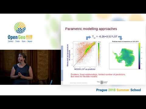
Remote sensing is a key method in bridging the gap between local observations and spatially comprehensive estimates of environmental variables. For such spatial or spatio-temporal predictions, machine learning algorithms have shown to be a promising tool to identify nonlinear patterns between locally measured and remotely sensed variables. While easy access to user-friendly machine learning libraries fosters their use in environmental sciences, the application of these methods is far from trivial. This holds especially true for spatio-temporal since its dependencies in space and time bear the risk of overfitting and considerable misinterpretation of the model performance.
In this introductory lecture I will introduce the idea of using machine-learning for the (remote sensing based) monitoring of the environment and how they can be applied in R via the caret package. In this context error assessment is a crucial topic and I will show the importance of "target-oriented" spatial cross-validation strategies when working with spatio-temporal data to avoid an overoptimistic view on model performances. As spatio-temporal machine-learning models are highly prone to overfitting caused by misleading predictor variables, I will introduce a forward feature selection method that works in conjunction with target-oriented cross-validation from the CAST package.
In summary this talk aims at showing how "basic" spatial machine-learning tasks can be performed in R, but also what needs to be considered for more complex spatio-temporal prediction tasks in order to produce scientifically valuable results. Based on this talk, we will go into a practical session on Tuesday, where machine-learning algorithms will be applied to two different spatial and spatio-temporal prediction tasks.
 0:53:25
Hanna Meyer: 'Machine-learning based modelling of spatial and spatio-temporal data'
 0:52:51
Hanna Meyer: 'Machine-learning based modelling of spatial and spatio-temporal data' (pract...
 1:49:35
Hanna Meyer - Machine learning for earth observation
 0:22:12
GSV2020 Estimating the area of applicability of spatial prediction models (Hanna Meyer)
 0:07:08
Interview: Hanna Meyer - Summer School 2020
 0:25:02
Hanna Meyer: Plenary - 04.09.2019
 1:21:11
Plenary: Hanna Meyer, Dainius Masiliunas, Paula Moraga
 1:14:57
OpenGeoHub Summer School - Room 1 - Day 4 - Hanna Meyer
 0:09:12
Profile: Hanna Meyer (Philipps University Marburg, Germany)
 0:12:57
Sensitivity of a Machine Learning-Based Model to Predict Chlorophyll-a Using Multi-Media Modeling
 0:33:08
What and where? - Machine learning for geospatial image analysis - Mathilde Ørstavik
 1:18:26
Plenary - 04.09.2019
 0:09:21
SAP HANA Spatial - Machine Learning with Geospatial Data
 1:50:22
Madlene Nussbaum - Mastering machine learning for spatial prediction (part 1)
 0:58:27
Machine Learning for Prediction of Terrestial Climate and Weather
 1:14:01
Madlene Nussbaum: Mastering ML for spatial prediction II - model selection and interpretation
 0:20:00
Madlene Nussbaum: Plenary - 05.09.2019
 1:15:09
Geospatial Data Science & Machine learning
 1:16:42
Madlene Nussbaum: Mastering ML for spatial prediction I - overview and introduction in methods
 2:01:45
Tutorial: Climate Change: Challenges for Machine Learning
 0:11:22
Data Mining the City: Agent Based Simulation for Spatial Behavior Prediction by Violet Whitney
 0:57:55
Earth Observation & Machine Learning for Agroecological Applications
 1:26:06
Introduction to Ensemble Machine Learning for Predictive Soil Mapping (landmap package) part I
 0:19:14
Boost your applications with in-database spatial & Machine Learning | Mathias Kemeter | SAP
Комментарии