filmov
tv
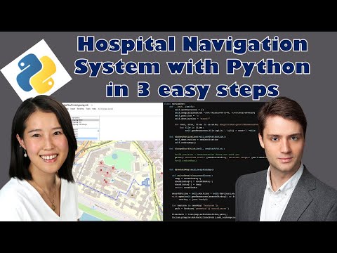
Building a Hospital Navigation System in Python in 3 easy steps

Показать описание
Chapters:
0:00 Intro + Explanation of the Hospital Map
3:40 What are the 3 Objectives for the Prototype
4:24 Introduction of the Jupyter Colab Notebook
6:03 Draw the map
6:30 Creation of the building outlines with geojson
9:35 Draw the path to the building with as an ant path
12:49 Create the interactive selection widget to pick the destination
15:01 Build the prototype
19:24The final product
22:41 Outlook
23:18 Upcoming videos
In this video we will build a Hospital Navigator (Indoor Navigation) in 3 easy steps with Python. We explain how you can create an interactive navigation system in 3 easy steps.
First, we initialize a map and create the building outlines using geojson to display the buildings in our map. Next, we build the ant path showing the way to the buildings. This ant path is an animated path which shows directions, i.e. what your start and destination points are. Third, we create interactive selectors using python widgets. With these selectors, you can choose the start and destination of your path.
Using these three components we build a hospital navigation System Prototype. This prototype displays buildings and a path from a specific start and destination point on a map.
We answer the following question: How to create your custom map? How to use geojson? How to draw building outlines? What is a geojson file? How do you create geojson files? What issues might come up when using geojson? What is an ant path? How can you draw an ant path with python? How do you create an interactive map?
#python #navigator #hospital #geovisualization
 0:24:41
Building a Hospital Navigation System in Python in 3 easy steps
 0:02:01
GPS Making Navigating A Hospital Easier
 0:00:51
Provide Indoor Navigation and Easy Wayfinding in Hospitals | Mapsted
 0:28:48
Navjunk = horrible hospital navigation (+ a solution)
 0:05:13
Mission Hospital's Campus Navigation App
 0:01:18
Interactive map demo of a hospital
 0:02:32
Indoor Navigation with Augmented Reality in a hospital
 0:01:00
AR Navigation in a Hospital - ARway
 0:01:00
ARway: AR Navigation in a Hospital
 0:00:46
IBS Hospital | Navigation-Guided Spine Surgery | Precision with Stryker’s Advanced Technology
 0:01:05
New Sarasota Memorial Hospital navigation app
 0:08:20
An Indoor Location System for Hospital Facilities.
 0:01:08
Desigining a Navigation System for Hospital Melaka
 0:00:27
Hospital App Navigation Assistant
 0:01:54
ARION - Indoor Navigation for Indus Hospital
 0:09:39
Indoor Navigation in AR with Unity and Revit
 0:02:09
Indoor navigation in hospital
 0:30:16
NHS Hospital Digital Twin for Better Resourcing and Care in Dynamic Situations
 0:00:50
What's Up: New Website - Hospital building navigation feature
 0:31:02
Unity tutorial: AR Indoor Navigation with Vuforia Engine - Workflow, data model & app demo
 0:00:53
iNavi (Indoor Navigation) Ankara City Hospital - 2
 0:00:50
2Guide indoor navigation: how to find the path in the hospital
 0:01:37
Mobile Robots (AGVs) in Hospital - Natural Navigation
 0:02:37
The Path Forward to Building Hospital Resilience
Комментарии