filmov
tv
GOES Satellite Data Shows Tornado Development

Показать описание
This animation of NOAA's GOES-East satellite data shows the development and movement of the weather system that spawned tornadoes affecting the southern and eastern U.S. states on April 27-29, 2014. Image Credit: NASA/NOAA GOES Project
 0:00:27
GOES Satellite Data Shows Tornado Development
 0:00:27
GOES Satellite Data Shows Tornado Development
 0:00:27
GOES Satellite Data Shows Tornado Development
 0:00:27
GOES Satellite Data Shows Tornado Development #Nasa #Goes #Noaa
 0:00:31
Animated NOAA GOES-13 satellite data shows space view of Great Plains tornado outbreak
 0:00:27
Nasa GOES Satellite Data Shows Tornado Development
 0:14:27
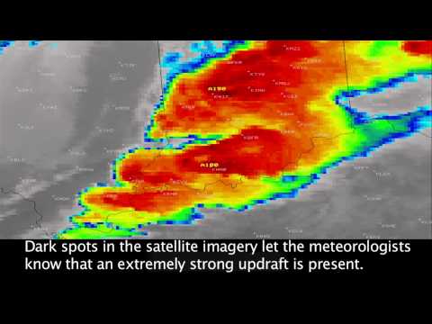
Storm Signatures Observed in Satellite Imagery
 0:00:31
NASA Satellite Movie Shows Great Plains Tornado Outbreak from Space
 0:00:06
High Speed Imagery of the Oklahoma Tornadoes
 0:00:22
NOAA GOES Satellite Sees March 12/13 Storm
 0:00:10
Tornado Spawning Storms Examined By NASA's GPM Satellite
 0:00:16
April 2010 U.S. Tornado Outbreak [1080p]
 0:00:28
Severe storms and tornadoes erupt in U.S.
 0:00:07
GOES-16 One-Minute Imagery of Tornadic Cells in Iowa on June 28, 2017
 0:00:45
Record Tornado Activity - Satellite View
 0:01:23
NASA | GOES Sees Tornadoes
 0:00:08
Satellite Loop of Tornadic Supercell - June 28, 2017
 0:00:09
GOES-East Visibile Satellite Imagery of Tornadic Supercells in Iowa on July 19, 2018
 0:00:25
Satellite movie shows tornado system's movement
 0:01:57
Tornado Size Comparison - 3D
 0:00:25
moore tornado, GOES-13 satellite image
 0:00:54
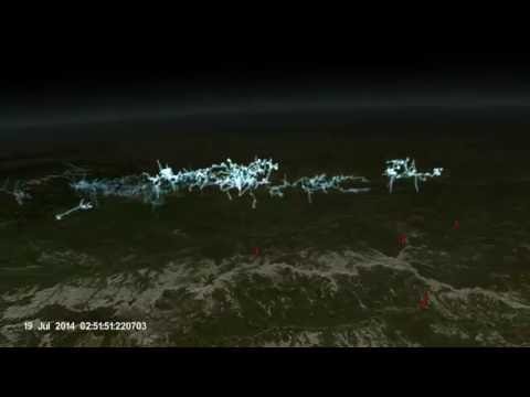
GOES-R Geostationary Lightning Mapper Data Visualization
 0:00:27
Tornado lighting flashes seen from space
 0:00:49
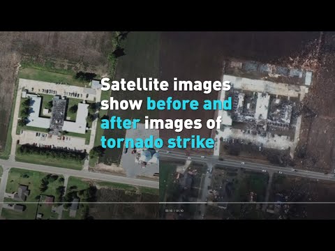
Satellite images show before and after images of tornado
Комментарии