filmov
tv
View your GIS project in 3D (QGIS 3D map tutorial)
Показать описание
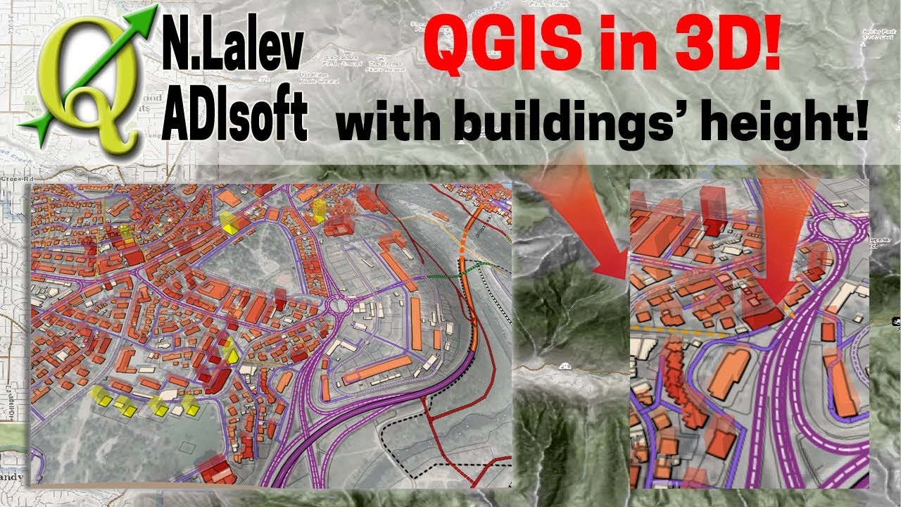
In this QGIS 3D map tutorial, we show you the easy process of how to set your QGIS environment in 3D using a simple plugin. We can load raster and vector layers, and elevate the heights. Buildings have their own height based on an attribute that we calculated. They all attach to the terrain beautifully.
The height of the buildings in the 3D QGIS map can vary and can be updated just by changing the attribute. A 3D qgis map is an asset to any urban presentation. You can save the images from the 3D QGIS map by print-screening or using any screen capture software. This QGIS 3D map tutorial is easy to follow and suitable for beginners. When presenting with a QGIS 3D map, you can draw on the screen to show specific areas.
If you have questions about the QGIS 3D map tutorial , please post them below.
- - - - - -
Thanks for watching. Make sure you check the whole QGIS playlist here:
---
Author/Автор: Nicola Lalev from ADIsoft
Date/Дата: 24/08/2019
Programs used / Използван софтуер:
-QGIS 2.18.26
 0:07:27
View your GIS project in 3D (QGIS 3D map tutorial)
 0:02:01
QGIS: Save Your GIS Project
 0:10:08
Top 5 Tips & Tricks for ArcGIS Pro - Change Your GIS Life!
 0:16:11
How to Build a Simple GIS Project
 0:06:29
Fixing GIS Data Misalignment Issues in ArcMap
 0:08:03
How to Use Your County's GIS Mapping System
 0:07:40
What should I do for my GIS project? Full Video
 0:33:30
ArcGIS Pro: Take Your GIS to the Next Frontier
 3:12:52
August 1, 2024 - Hendersonville City Council Meeting
 0:05:32
Importing GIS shapefiles into Google Earth Engine
 0:15:12
FASTEST Way to Learn Modern GIS and ACTUALLY Get a Job
 0:10:56
GIS: Mapping your World
 0:04:30
Importing Excel Coordinates to ArcMap and Plotting
 0:01:49
The First Key to a Successful GIS Project
 0:03:11
GIS For Biologists: Tip #4 - Setting A Projection/Coordinate System For Your GIS Project
 0:06:23
Download GIS Shapefile Data ( Road, Structure etc.) for Any Country: osm to shapefile
 0:38:42
Towards a More Realistic GIS Solution- 3D Cadastre
 0:07:03
Shapefile from Google Earth to GIS || Study Area Extraction from Google Earth and export to ArcMap
 0:12:21
Develop ArcGIS Android Mobile GIS and GPS Apps : Display a Basemap
 0:00:43
Free GIS software for your school!
 0:08:07
3 FREE Digimap Alternatives for Site Analysis and Site Plans
 0:05:14
Backup and Share GIS Data & Project using Map Package | ArcGIS
 0:26:07
How to use R as GIS tools: here is my own learning experience
 0:22:11
GIS Field Survey using QField (offline method)
Комментарии