filmov
tv
AltoMaxx: Drone-Based Bathymetry
Показать описание
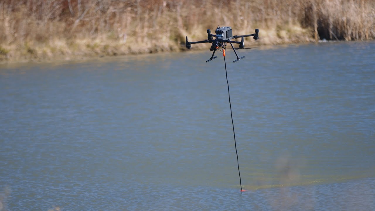
AltoMaxx is revolutionizing bathymetric data acquisition with its fleet of state-of-the-art drones and sensors.
Bathymetry measures the depth beneath water surfaces, producing underwater maps of riverbeds, creek systems, lake bottoms, ocean floors, wastewater treatment ponds, and tailings ponds. This bathymetric data can be used to calculate water volume, measure sediment deposits, document coastal erosion, and provide other critical insights about water resources.
Drone-based bathymetry services are unencumbered by the typical infrastructure, expenses, and limitations associated with other platforms. Drones are versatile and able to be deployed in situations where traditional bathymetry methods are impractical or unsafe, such as shallow coastal areas, strong current systems, and caustic tailing ponds.
AltoMaxx bathymetric surveys utilize autonomous, pre-planned flights to provide maximum efficiency, while precise GPS positioning systems ensure accurate data and repeatable survey lines. Through drone technology, AltoMaxx can provide fast and cost-effective access to bathymetric data – allowing clients to make informed decisions and successfully manage their assets.

AltoMaxx: Drone-Based Bathymetry

AltoMaxx - Bathymetry (Shorts)

AltoMaxx - GPR/Bathymetry In Strong Currents (Shorts)

We Are AltoMaxx - 2024

AltoMaxx Professional Critical Infrastructure Inspections

Professional Drone Services Privacy Concerns | AltoMaxx

Drone CZMIL Bathymetry Lidar

AltoMaxx Ground Penetrating Radar Surveys

GPR-drone integrated system for bathymetry survey

Webinar | Drone GPR: A Modern Solution for Underground Utility Locating | AltoMaxx & SPH Enginee...

Webinar | Exploring Depths From Above: Unleashing The Potential Of Drone-Based Bathymetry

UgCS Integrated Systems Webinar - April 6, 2021

SkyMap Africa Bathymetry Drone

Drone de bathymétrie USV200 multifaisceaux + Lidar à Mauves-sur-Loire (44)

Bathymetric survey of Silkeborg Lake using drone with low frequency GPR

Drone Magnetic survey 2023

Dam tailings drone bathymetry

Drone equipped with Ground Penetrating Radar GPR for freshwater bathymetry

FoxBathy bathymetric drone catamaran l Hlicodescargaryoutube com

SYNCHRONIZATION OF AIRBORNE PHOTOGRAMMETRY, LIDAR, AND BATHYMETRY SURVEYING FOR COASTAL MAPPING

Single Beam Survey, Bathymetry!

2-in-1 Bathymetric Airborne LiDAR + Aerial Terrestrial LiDAR

SkyMap Africa Drone Bathymetric Survey

Montage du Multiboat en moins de 10min - drone marin de bathymétrie - Escadrone
Комментарии