filmov
tv
Basic Topology in ArcMap

Показать описание
TOPOLOGY IN ArcGIS
Music credit:
Author: Kevin MacLeod
Creating a topology using the Catalog window or ArcCatalog
Here is the process used to create a topology using ArcCatalog.
Right-click the feature dataset to which you want to add a topology, point to New, then click Topology.
Click Next.
Name the new topology and specify the cluster tolerance. The default value will be set to the x,y tolerance of the feature dataset. A good default value is 0.001 meters or its equivalent in the units of your spatial reference (for example, 0.003281 feet if your units are in feet or 0.0000000556 degrees if your units are in latitude-longitude as decimal degrees).
Click Next.
Next, choose the feature classes that will participate in the topology. You will be shown a list of all the feature classes in your feature dataset.
Click Next.
Set the coordinate accuracy ranks for each feature class in the topology.
If one or more of your feature classes contain coordinate z-values, click Z Properties to set the z-ranks. The z-tolerance is used to distinguish the z-height, or elevation of vertices within the tolerance of one another. For example, two adjacent features of different heights might share a common edge between them. However, only their x,y vertices are colocated, not their z-value or height. The z-tolerance helps process this information correctly during validation and clustering operations. The default z-tolerance value is the same default value as the x,y tolerance (0.001 meter in real-world units).
Click Next.
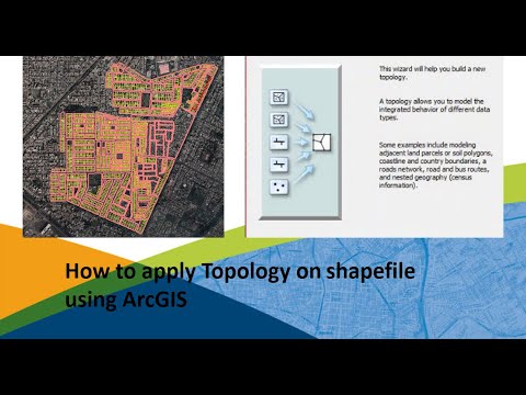
Add the series of topology rules that help you structure the spatial relationships between features and to control and validate how features share geometry.
Click Next.
Review the summary and click Finish. You have now added the new topology to your feature dataset. You will be asked if you would like to validate your topology in your feature dataset now. If you have data in your feature classes, you can choose Yes.
Creating a topology using geoprocessing
ArcToolbox contains a series of geoprocessing tools for topology. The Topology toolset is located in the Data Management toolbox.
These tools can be used to build scripts for creating and modifying geodatabase topologies. Scripts can be useful for automating a series of tasks and for building repeatable workflows.
An overview of topology in ArcGIS
ArcMap 10.3 | Other versions
Topological relationships
If you have features that are coincident and share the same location of coordinates, boundaries, or nodes, chances are that geodatabase topology can help you better manage your geographic data.
Geodatabase topologies help you ensure data integrity. Using a topology provides a mechanism to perform integrity checks on your data and helps you to validate and maintain better feature representations in your geodatabase.
In addition, you can use topologies for modeling numerous spatial relationships between features. These enable support for a variety of analytic operations, such as finding adjacent features, working with coincident boundaries between features, and navigating along connected features.
Topological relationships
Topology is the arrangement for how point, line, and polygon features share geometry. Topology is employed to do the following:
Constrain how features share geometry. For example, adjacent polygons such as parcels have shared edges, street centerlines and census blocks share geometry, and adjacent soil polygons share edges.
Define and enforce data integrity rules: no gaps should exist between polygons, there should be no overlapping features, and so on.
Support topological relationship queries and navigation, such as to identify feature adjacency and connectivity.
Support sophisticated editing tools that enforce the topological constraints of the data model.
Construct features from unstructured geometry, such as to create polygons from lines.
The process of building a topology from existing data can be summarized in the following steps:
Music credit:
Author: Kevin MacLeod
Creating a topology using the Catalog window or ArcCatalog
Here is the process used to create a topology using ArcCatalog.
Right-click the feature dataset to which you want to add a topology, point to New, then click Topology.
Click Next.
Name the new topology and specify the cluster tolerance. The default value will be set to the x,y tolerance of the feature dataset. A good default value is 0.001 meters or its equivalent in the units of your spatial reference (for example, 0.003281 feet if your units are in feet or 0.0000000556 degrees if your units are in latitude-longitude as decimal degrees).
Click Next.
Next, choose the feature classes that will participate in the topology. You will be shown a list of all the feature classes in your feature dataset.
Click Next.
Set the coordinate accuracy ranks for each feature class in the topology.
If one or more of your feature classes contain coordinate z-values, click Z Properties to set the z-ranks. The z-tolerance is used to distinguish the z-height, or elevation of vertices within the tolerance of one another. For example, two adjacent features of different heights might share a common edge between them. However, only their x,y vertices are colocated, not their z-value or height. The z-tolerance helps process this information correctly during validation and clustering operations. The default z-tolerance value is the same default value as the x,y tolerance (0.001 meter in real-world units).
Click Next.
Add the series of topology rules that help you structure the spatial relationships between features and to control and validate how features share geometry.
Click Next.
Review the summary and click Finish. You have now added the new topology to your feature dataset. You will be asked if you would like to validate your topology in your feature dataset now. If you have data in your feature classes, you can choose Yes.
Creating a topology using geoprocessing
ArcToolbox contains a series of geoprocessing tools for topology. The Topology toolset is located in the Data Management toolbox.
These tools can be used to build scripts for creating and modifying geodatabase topologies. Scripts can be useful for automating a series of tasks and for building repeatable workflows.
An overview of topology in ArcGIS
ArcMap 10.3 | Other versions
Topological relationships
If you have features that are coincident and share the same location of coordinates, boundaries, or nodes, chances are that geodatabase topology can help you better manage your geographic data.
Geodatabase topologies help you ensure data integrity. Using a topology provides a mechanism to perform integrity checks on your data and helps you to validate and maintain better feature representations in your geodatabase.
In addition, you can use topologies for modeling numerous spatial relationships between features. These enable support for a variety of analytic operations, such as finding adjacent features, working with coincident boundaries between features, and navigating along connected features.
Topological relationships
Topology is the arrangement for how point, line, and polygon features share geometry. Topology is employed to do the following:
Constrain how features share geometry. For example, adjacent polygons such as parcels have shared edges, street centerlines and census blocks share geometry, and adjacent soil polygons share edges.
Define and enforce data integrity rules: no gaps should exist between polygons, there should be no overlapping features, and so on.
Support topological relationship queries and navigation, such as to identify feature adjacency and connectivity.
Support sophisticated editing tools that enforce the topological constraints of the data model.
Construct features from unstructured geometry, such as to create polygons from lines.
The process of building a topology from existing data can be summarized in the following steps:
 0:06:03
 0:06:55
 0:09:49
 0:10:02
 0:07:56
 0:04:50
 0:01:52
 0:02:51
 0:11:05
 0:07:45
 0:08:38
 0:04:54
 0:07:04
 0:02:26
 0:00:48
 0:07:54
 0:16:06
 0:48:03
 0:07:21
 0:10:47
 0:26:44
 0:02:21
 0:10:35
 0:09:49