filmov
tv
Field Measurement Book, Tippani Ladder - Land Records - CAD Software

Показать описание
--------Contents of this Video-------
Software for Preparing Tippan Map Using Ladder Data - Ladder to Map.
0:00 -Introduction to Tippan Module
1:05 -Draw perpendiculars
1:21 -Adjust ladder lengths
1:59 -Measure the Distance between points
2:09 -Create Boundary automatically
2:28 -Create dimensions of ladder entities
2:41 -Get the dimensions in both Acres - Gunthas and Metric System
#landmap, #fmb, #landrecords, #ladderdiagram, #landsurvey, #infrastructure, #autocad, #bricscad, #totalstation
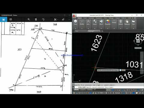
Tippan is a LISP Package for developing the ladder diagram. It also helps in creating the Boundary automatically, dimensioning the entities and finding the areas.
Tippan is a basic survey document prepared in the field while doing a survey. It is a document that contains parcel-wise field measurements (For each survey boundary). Most of the maps available are hand-drawn and not to scale. This module is very simple and helps you to create the Tippan Maps to scale in very simple steps. It’s a collection of LISP Routines that simplify every step in creating a Tippan Boundary by eliminating the efforts of converting measurement units, drawing perpendiculars and changing dimensions.
Converting the Land records into digital format is now largely adopted all over, and these tools are very convenient to achieve the same.
Features:
Create ladders by reading the data directly from the field book by eliminating the process of typing them into text format and then converting them as drawings or creating every single component in CAD packages.
Draw perpendiculars easily
Adjust ladder lengths easily
Measure Distance between points, and Clockwise/Anti-Clockwise Bearings of entities easily
Create Boundary automatically by referring to the Ladder Diagram
Create dimensions of ladder entities and boundaries along with the area in a single command
Get the dimensions in both Acres - Gunthas and Metric System Create Base Triangle and Sub Triangle and generate Tippan Map
---------Related Subjects---------
Field Measurement Book, Tippani Ladder - Land Records - CAD Software
FMB
Ladder diagram
Land records
Field measurement book
Pahani
Ladder to map
Adjusting ladder lengths
Survey Map
Land survey tippan
Chain and Anna
Land record map
Land mapping and surveying
Bearing measurement
Plotting Land Survey maps
Infrastructure Engineering
Structural Layers
Land Acquisition
----Information about channel-------
-----Social media-----
Works with
#AutoCAD
#BricsCAD
#ZWCAD
 0:03:59
Field Measurement Book, Tippani Ladder - Land Records - CAD Software
 0:10:28
how to read land map easily | how to read fmb map | read land drawing | pattachitta | fmb sketch
 0:02:09
Tippan-Preparing Ladder Data for Tippan (Meters)
 0:01:41
Tippan Software - Generate Tippan Map from Ladder Data
 0:01:59
Tippan Software - Preparing Ladder Data for Tippan (Chain Annas)
 0:06:33
FMB Full Details || AP Farmer
 0:38:38
FMB plotting in Autocad || Mana Surveyor
 0:00:27
Lay Hand Prayer,Bishop Amardeep Ministry #bishopamardeepministry
 0:08:31
Basic Tutorial On How To Plot a Survey Plan on AutoCAD For Beginners.
 0:05:28
How to calculate land Area of different shapes.#area_calculation
 0:05:51
Ladder entry in autocad
 0:02:51
DGPS 3 || Inverse tool/dist. measurement || DGPS || Mana Surveyor
 0:00:11
TITOK NEW COUPLE COURT MARRIAGE VIDEO VIRAL ❤
 0:05:50
#Aptchcnav landstar7 survey
 0:03:38
Collabland tippan drawing
 0:03:03
Total station to CollabLand
 0:01:47
TPC Mortgage Survey: Scaling and Positioning Your New Drawing
 0:00:13
plastering uae
 0:08:23
Vehicular Underpass Drawing Software
 0:09:49
Measure land area by software (SolidWorks) - Raqba Nikalne ka Asan Tarika - How to find land Area
 0:07:31
How To Download Land FMB(TIPPON) From Dharani in Telangana || Tech Patashala
 0:19:03
Land Surveying 2022 | RNR CIVIL SURVEYORS - Digital Land Survey | Ramesh Nagara | SumanTV Shorts
 0:00:52
Last Day of Exams at IIT Delhi 😫🔥🥳 #minivlog #short #iit #collegelife
 0:08:23
LAND SURVEY REPORT... MAPPING ... /By Yousuf Khan/
Комментарии