filmov
tv
NDVI | Vegetation/Forest Cover Map in ArcGIS

Показать описание
How to NDVI in arcGIS. Hope you will learn easily how to do NDVI for your study area.
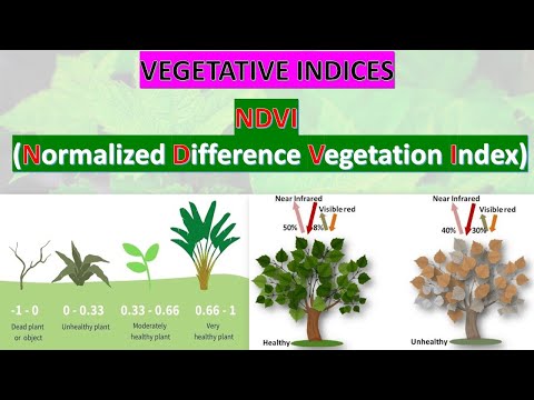
NDVI Calculation Equation:
NDVI=(PIR-R)/(PIR+R)
In Landsat 8,
NDVI=(B5-B4)/(B5+B4)
In Landsat 4-7,
NDVI=(B4-B3)/(B4+B3)
Our others important Tutorial:
Music Credit:
Creative Commons — Attribution 3.0 Unported — CC BY 3.0
Related tags: NDVI, How to NDVI, NDVI in arcGIS, NDVI map, Normalized Difference Vegetation Index (NDVI), How to NDVI in arcGIS, How to NDVI in GIS, NDVI for study area
If you want to learn GIS and Remote sensing in easy way, you can Subscribe my YouTube channel. I am trying to make easy tutorials for beginners. I’m on the way to prepare more essential tutorials for you.
 0:05:09
NDVI | Vegetation/Forest Cover Map in ArcGIS
 0:09:35
NDVI / Vegetation / Forest cover map in ArcGIS
 0:07:30
NDVI|Vegetation cover map|Forest Cover map|ArcGIS @gistutorial_easytutorial
 0:04:09
How To Create NDVI Maps in ArcGIS Pro
 0:06:34
Calculating Area of Vegetation Cover in ArcMap Using NDVI Tool
 0:16:15
Google Earth Engine 5: NDVI | Vegetation Analysis (Landsat 8) - Beginners Guide
 0:23:33
Forest Cover Classification using SVM in ArcGIS| Forest Cover Mapping| Identify Forest Type Class.
 0:11:44
NDVI with class range in ArcGIS
 0:24:22
Deforestation & Afforestation Map from 1990 to 2020 Using ArcGIS
 0:07:40
NDVI - NORMALIZED DIFFERENCE VEGETATION INDEX | GATE GEOMATICS ENGINEERING | #ndvi #gate #soil
 0:15:08
NDVI Change Detection Analysis using Landsat 8 | Google Earth Engine
 0:06:37
how do I extract vegetation Range from NDVI data| Extract NDVI Range values from Minimum to Maximum
 0:15:22
NDVI change detection and Calculate the total Area || Vegetation change detection in ArcMap
 0:02:25
5 Things To Know About NDVI (Normalized Difference Vegetation Index)
 0:11:41
NDVI change detection and Calculate the total Area of Dense vegetation using Google Earth Engine
 0:07:57
NDVI area calculation | Calculate area from pixel | NDVI values range
 0:25:40
Estimation of NDVI by Regression analysis using ArcGIS Software - A simple Case study
 0:15:58
Calculate NDVI from Landsat 8 Image I Classify NDVI Range in ArcGIS
 0:01:57
Experiments on the Linking Ground ForestInventory and NDVI in Mapping above Ground Carbon Stock in
 0:00:04
Vegetation Health Index - 2019
 0:00:30
NDVI in Google Earth Engine ||Shorts
 0:00:49
Spatial and Temporal Patterns of Global NDVI Trends: Correlations with Climate and Hu... | RTCL.TV
 0:08:45
Vegetation Forest Canopy Cover Estimation Using LIDAR/Photogrammetric Point Clouds Data and ArcGIS
 0:14:24
Calculating NDVI using QGIS and Landsat 8 Images
Комментарии