filmov
tv
🛑Live Google Earth Engine For Making Land Use and Land Cover Mapping using Machine learning Method

Показать описание
🛑Live Google Earth Engine For Making Land Use and Land Cover Mapping using Machine learning Method
Start with Google Earth Engine & Spatial Analysis beginners 19th batch.
Registration is open for the 'Online Training on Google Earth Engine (GEE) for Remote sensing Analysis for Beginner's, 19th Batch.
Online training program Conducted by @StudyHacks (Institute of GIS & Remote sensing)
Take advantage of this discount and register very first!!!
Register 1st 5 People to get a 50% Discount.
Classes will be via Zoom on the 27th, 28th & 29th of August from 9.00 pm until 12.00 AM (BD time) or 21:00 to 00:00 (GMT+6);
Class Duration: 3 hours
Training on Google Earth Engine (GEE) for Remote sensing Analysis for Beginners, 19th Batch, this class will teach you all the things you need to start using GEE for your remote sensing analysis. We mainly focus on these people who don't know any programming language and Earth Engine function. After completing this course, you are able to do any Remote sensing analysis very quickly and efficiently using the Google Earth Engine Platform. We cover LULC mapping, Air quality, Monitoring, Time series analysis, Calculating any Indices, Supervised Classification, Machine Learning Methods, and more.
Course Content:
1) Introduction to Google Earth Engine, How to create a verified Earth Engine account
2) Basic JavaScript Programming Language
3) Client VS Server Object: Earth Engine Server Function
4) Filtering visualizing satellite imagery: Landsat, Sentinel, Modis
5) Importing and Exporting Raster and Vector data
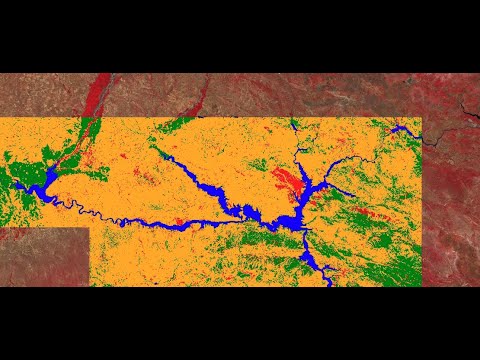
6) Making Landuse and LandCover Classification Map in GEE
7) Computation with satellite imagery: Band Calculations
8 ) Making time series Chart analysis
9) Air Quality Monitoring using sentinel-5
10)Spectral indices and develop the Skills for calculating any Index (NDVI, NDWI, NDSI, MNDWI, MSAVI, etc.)
Course Fee: 400$ ( Take advantage of this discount for the First 5 people who can join this course 50% discount of only 200$ )
Take advantage of this discount and register very first!!!
There are already over 150+ students who have taken part in our training and courses and many are already developing their own codes and research with the GEE
.Join Our Community:
#gis #remotesensing #googleearthengine #EarthEngine
Start with Google Earth Engine & Spatial Analysis beginners 19th batch.
Registration is open for the 'Online Training on Google Earth Engine (GEE) for Remote sensing Analysis for Beginner's, 19th Batch.
Online training program Conducted by @StudyHacks (Institute of GIS & Remote sensing)
Take advantage of this discount and register very first!!!
Register 1st 5 People to get a 50% Discount.
Classes will be via Zoom on the 27th, 28th & 29th of August from 9.00 pm until 12.00 AM (BD time) or 21:00 to 00:00 (GMT+6);
Class Duration: 3 hours
Training on Google Earth Engine (GEE) for Remote sensing Analysis for Beginners, 19th Batch, this class will teach you all the things you need to start using GEE for your remote sensing analysis. We mainly focus on these people who don't know any programming language and Earth Engine function. After completing this course, you are able to do any Remote sensing analysis very quickly and efficiently using the Google Earth Engine Platform. We cover LULC mapping, Air quality, Monitoring, Time series analysis, Calculating any Indices, Supervised Classification, Machine Learning Methods, and more.
Course Content:
1) Introduction to Google Earth Engine, How to create a verified Earth Engine account
2) Basic JavaScript Programming Language
3) Client VS Server Object: Earth Engine Server Function
4) Filtering visualizing satellite imagery: Landsat, Sentinel, Modis
5) Importing and Exporting Raster and Vector data
6) Making Landuse and LandCover Classification Map in GEE
7) Computation with satellite imagery: Band Calculations
8 ) Making time series Chart analysis
9) Air Quality Monitoring using sentinel-5
10)Spectral indices and develop the Skills for calculating any Index (NDVI, NDWI, NDSI, MNDWI, MSAVI, etc.)
Course Fee: 400$ ( Take advantage of this discount for the First 5 people who can join this course 50% discount of only 200$ )
Take advantage of this discount and register very first!!!
There are already over 150+ students who have taken part in our training and courses and many are already developing their own codes and research with the GEE
.Join Our Community:
#gis #remotesensing #googleearthengine #EarthEngine
 0:50:42
🛑Live Google Earth Engine For Making Land Use and Land Cover Mapping using Machine learning Method...
 0:06:13
🛑Live Google Earth Engine For Making Land Use and Land Cover Mapping using Machine learning Method...
 0:08:19
ChatGPT and Google Earth Engine: A Match Made in Heaven for Satellite Image Processing
 1:01:05
🛑Live Training on Google Earth Engine for 7 days for Remote sensing analysis || Earth Engine
 0:12:28
Download Latest Global Land Cover data 10m Resolution from Google Earth Engine | 2015 to 2023
 0:56:20
🛑Live training on Google Earth Engine online training for remote sensing analysis
 0:47:54
🛑Live Google Earth Engine Filtering and Displaying Satellite Images: Landsat, Sentinel using GEE...
 0:24:27
🛑Live Training on Google Earth Engine for creating Earth Engine Web application for NDVI Time series...
 0:19:58
How to monitor Precipitation Deficit using Google Earth Engine || CHIRPS
 0:19:43
🛑Live Training on Google Earth Engine for 7 days for Remote sensing analysis || Earth Engine
 0:27:23
🛑 Live Google Earth Engine beginner's to Advanced Remote sensing Analysis
 0:02:32
How to Access Data from Google Earth Engine Code Editor | Google Developer Communities North America
 0:39:10
🛑Live Google Earth Engine TRAINING 18th Batch: Filtering and displaying Satellite Imagery using GEE...
 0:00:58
Places You Should Never Search on Google Earth
 0:00:17
I Found Titanic On Google Maps! 🌎🚢 #shorts #googleearth #googlemaps
 0:00:58
Google Earth VS SpaceEngine Earth
 0:56:30
Geo for Good 2022: Time-Series Processing using Google Earth Engine
 0:03:09
Google Earth Engine Public Data Catalog | Google Developer Communities North America
 0:51:01
🛑19th Batch || Live Training on Google Earth Engine for 3 days for Remote sensing analysis || GEE
 1:35:07
Google Earth Engine 101: An Introduction for Complete Beginners
 0:29:05
🛑Live online training: NDBI & NDVI mapping using Google earth engine || Remote sensing Analysis...
 0:00:26
I Found TITANIC Shipwreck ON GOOGLE EARTH !😱 #shorts #titanic
 0:21:12
Real time Crunching of Petabytes of Geospatial Data with Google Earth Engine | SciPy 2014 | Randy Sa
 0:59:59
Geo for Good 2022: Earth Engine for Non-coders
Комментарии