filmov
tv
Dangerous California storm could trigger life-threatening flooding

Показать описание
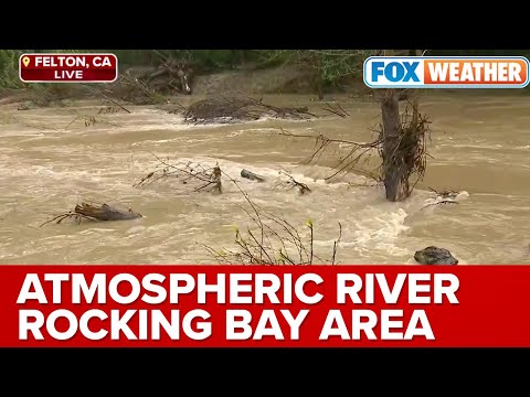
Forecasters at the National Weather Service are warning of a “significant threat of widespread and very dangerous flash flooding” Saturday night through Tuesday for much of densely populated Southern California. The cause is a particularly intense atmospheric river that will aim a fire hose of moisture at the coast and run up against the region’s mountainous terrain. The potential for flooding is highest from around Santa Barbara to the south, although flood watches have been hoisted from San Francisco and the northern Central Valley to the border with Mexico. Strong winds, mountain snow and dangerously high surf are also a concern. The Weather Service office serving the Los Angeles region is cautioning that the expected torrents could trigger rock and mudslides in the mountains, and flooding of small streams, rivers and roadways throughout the region. Burn scars left behind by wildfires will be particularly prone to flooding and debris flows. Evacuation orders have already been issued for burn scar areas and some properties in Montecito in Santa Barbara County.“Flooding issues will not be confined to just the foothills, mountains, and burn areas,” the Weather Service wrote in a discussion Saturday. “ALL AREAS, INCLUDING HIGHLY POPULATED URBAN AREAS, WILL BE AT RISK FOR LIFE-THREATENING FLOODING. Streams and small rivers, as well as the Los Angeles River through the San Fernando Valley and metro LA will rise quickly and turn into very dangerous raging rivers. Many roads will be impassable due to flooding.”The renewed potential for flooding comes just days after another atmospheric river dumped several inches of rain across portions of the state, including record daily amounts in Southwest California. Many foothill and mountain areas could see 6 to 12 inches of rain. Santa Barbara, a coastal city with steep mountains behind it, could be particularly vulnerable. Such amounts have caused “major” problems in the past, the Weather Service said.“Between the tremendous amount of moisture that this storm has with it, good southerly flow and slow movement — those are all the ingredients for some of our biggest storms,” said David Bruno, a meteorologist with the Weather Service in Oxnard, Calif. “But I want to stop short of saying that this is going to be something we’ve never seen before.”Downtown Los Angeles is expected to pick up 4 to 5 inches of rain, which wouldn’t be unprecedented for a two-day period. “However, if we start talking 6 or 7 inches of rain in two days, then we’re close to the top few events ever,” Bruno said. The Center for Western Weather and Water Extremes, based in La Jolla, Calif., predicts that the atmospheric river will reach Category 3 on its one-to-five scale, with Category 5 being the most extreme. The scale defines a Category 3 atmospheric river as “strong” and producing a “balance of beneficial and hazardous impacts,” including the threat of flooding but also helping to refill reservoirs.
#newschannel #newstodayheadlines #usnewsworldreport#newstodaymsnbc #newstodayabc #newstodayinusa #
#newschannel #newstodayheadlines #usnewsworldreport#newstodaymsnbc #newstodayabc #newstodayinusa #
 0:03:20
 0:05:00
 0:04:19
 0:19:55
 0:26:05
 0:00:33
 0:10:04
 0:04:40
 0:03:30
 0:02:29
 0:07:22
 0:02:26
 0:02:09
 0:01:55
 0:02:53
 0:01:54
 0:02:38
 0:14:41
 0:12:31
 0:03:23
 0:02:19
 0:02:17
 0:07:11
 0:02:38