filmov
tv
Modeling COVID-19 in ArcGIS
Показать описание
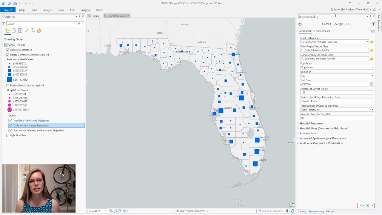
In this video Lauren Bennett and Lynne Buie explore the COVID-19 Modeling Toolbox, including its uses within the ArcGIS community and the new COVID-19 Surge (CDC) tool that was added. The ability to explore different reopening scenarios is highlighted.
---------------------------------------------------------------------------------------------------
Follow us on Social Media!
---------------------------------------------------------------------------------------------------
Follow us on Social Media!
 0:07:00
Modeling COVID-19 in ArcGIS
 0:10:55
COVID-19 Response: CHIME Model Introduction
 0:55:27
COVID-19 Data and Resources for the PSAP
 0:11:53
Space Planning for COVID-19 Recovery with ArcGIS Indoors
 0:54:12
Responding to COVID-19: Resources and GIS Solutions for Emergency Managers
 0:56:50
CHIME Model Geoprocessing Tool
 0:29:20
Seminar: GIS-based spatial modeling of COVID-19 in the US
 0:09:55
Covid-19 data from Living Atlas (ArcGIS OnLine) in ArcGIS Pro
 0:55:32
URISA & Esri: GIS Tools,Templates, and Free Resources for COVID-19
 0:11:59
How to Create coronavirus Map in ArcGIS !! Health GIS
 0:03:35
COVID-19 Response: COVID Pulse App
 0:17:44
Exploring Relationships Between COVID-19 Rates and Socio-Demographic Variables
 1:08:38
GIS and COVID-19: How Mapping Supports the Response and Recovery
 1:00:41
Five Lessons Learned from COVID-19 Response: An ArcGIS Hub Webinar
 0:08:04
ArcGIS Survey123: Feeding America During COVID-19
 0:49:47
ArcGIS Insights for Data Science Webinar
 0:10:00
Deploying the Coronavirus Response using the ArcGIS Solutions Deployment Tool
 0:57:39
Create your first ArcGIS Dashboard using COVID-19 data
 0:25:13
COVID-19 & Crisis Management - A GIS Approach
 0:54:37
Discuss the New Coronavirus Response Solution
 0:58:37
GIS and Data Mapping: Regional COVID 19 Response Examples
 0:48:50
GIS and COVID-19
 0:57:52
Using Insights for ArcGIS to Understand Your Data
 0:17:56
How to Visualize COVID-19 Data in ArcMap || Coronavirus Map in ArcGIS || Cartography
Комментарии