filmov
tv
Introduction to Spatial Data in Alteryx

Показать описание
In this Alteryx tutorial, we teach you how to get started using Spatial Data in Alteryx. Spatial Data refers to the records within the data set that have geographic aspects. We show you how to use Points, Lines and Polygons within the Alteryx platform.
If you're looking for an advanced analytics or data science tool for data preparation and big data analysis, Alteryx might just be for you.
💻Watch more free popular training tutorials from Simon Sez IT:
✅Check out our FREE 300+ hour training course playlist here 👉
✅Data Visualization playlist here
✅Excel 2021 Tutorials for Beginners playlist
✅Power BI Tutorials for Beginners. Master Power BI! playlist
✅Alteryx for Beginners playlist
💬Stay in touch!
🔔Subscribe to our channel:
If you enjoyed the video, please give a "thumbs up" and subscribe to the channel 👍🏽 ;-)
 0:07:08
Introduction to Spatial Data & GIS
 0:08:03
What is Spatial Data - An Introduction to Spatial Data and its Applications
 0:19:24
Week 1a: What is spatial analysis? (Introduction to Spatial Data Science)
 0:55:00
An introduction to spatial data governance and management
 0:11:30
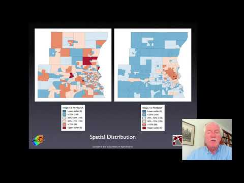
Introduction to Spatial Data in Alteryx
 0:37:06
Introduction to Spatial Data Analysis with Python
 0:01:42
Spatial Data Management Week 1: Course Introduction
 2:44:43
Christy Heaton - Intro to Spatial Analysis and Maps with Python - PyCon 2018
 1:11:29
Mapping crime data in R: An introduction to GIS and spatial data
 0:31:57
Introduction to Spatial Analysis
 0:03:09
Spatial Data Analysis 1: Introduction
 0:08:03
What Is GIS? A Guide to Geographic Information Systems
 0:37:06
Introduction to Spatial Data Analysis with Python
 0:27:39
Introduction to Spatial Data Analysis
 1:55:19
Introduction to Geospatial Data
 0:03:54
An introduction to Geospatial analytics
 0:51:03
Martin Fleischmann - A Gentle Introduction to Spatial Data in the Pandas Ecosystem [PyData Prague]
 2:01:11
QGIS 101: An Introduction to Spatial Data with Open Source Software
 1:33:07
NASA ARSET: Introduction to Spatial Data and Policies for Biodiversity, Part 1/3
 0:03:47
A brief introduction to GIS Data: raster and vector
 2:33:20
Introduction to spatial data analysis in R Tutorial
 1:01:27
Mapping crime data in R: An introduction to GIS and spatial data workshop
 0:09:56
Introduction to spatial sequencing data analysis
 0:17:49
GIS or Spatial Data Science: Get started today!
Комментарии