filmov
tv
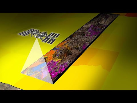
Meet EMIT, the Newest Imaging Spectrometer on the International Space Station

Показать описание
NASA's Earth Surface Mineral Dust Source Investigation (EMIT) uses a visible to short-wave infrared (VSWIR) imaging spectrometer on the International Space Station to record light reflected from Earth's surface to measure the surface composition of deserts and arid regions. A primary goal of this mission is to assess the impact of Earth’s mineral dust sources on the heating and cooling of our atmosphere and to predict how future climate scenarios might change the amount and type of mineral dust emitted into Earth’s atmosphere.
Data from the EMIT mission have been used to quantify greenhouse gas emissions from point source emitters and can also be applied to other disciplines for mapping fire, harmful algal blooms, and snow melt. EMIT has a 75-kilometer viewing swath, 285 spectral bands, a 60-meter spatial resolution, and collects data between 52° north and south latitude.
In this webinar, scientists from the EMIT Science Team at NASA's Jet Propulsion Laboratory and NASA’s Land Processes Distributed Active Archive Center (LP DAAC) introduce you to the EMIT mission and measurements, provide the basics of imaging spectroscopy, show how to discover and access EMIT data and provide data learning resources for working with these data.
A question-and-answer period follows the presentation.
Presentation slides
Phil Thompson (3rd speaker): No slides, all live demo
-------------------------
Webinar links
 1:18:06
Meet EMIT, the Newest Imaging Spectrometer on the International Space Station
 0:02:30
EMIT Imaging - Introducing Cryo-Fluorescence Tomography and Xerra
 0:05:08
EMIT Installation Animation (Earth Surface Mineral Dust Source Investigation)
 0:21:20
TechExchange 17 March 2022 - Antoinette Cordova, EMIT Imaging
 0:00:31
What Is NASA’s Earth Surface Mineral Dust Source Investigation EMIT
 0:01:00
How is Positron Emission Tomography (PET) Scan better than CT Scan and MRI?
 0:04:25
How does a PET scan work?
 0:00:54
Retirement is about exploring your wide open future.
 0:05:53
Super resolution microscopy | Stimulated emission depletion (STED) microscopy
 1:08:48
NASA’s EMIT Imaging Spectroscopy Mission - Dr. David Thompson
 0:00:39
This new tool allows #NASA scientists to pinpoint the locations that emit the most methane.
 1:51:27
EMIT Data Tutorial Series Workshops Week 1: Intro to EMIT Mission and Data
 0:01:23
Coffee & Creative | Agency Promo | Best Digital Agency | 2022
 0:01:22
This 3D-Printed Meat Cuts Like Steak
 0:02:59
The Earth Surface Mineral Dust Source Investigation (EMIT) by NASA.
 0:11:30
3-2 METHODS II: Positron Emission Tomography (11mins)
 0:02:59
What Is NASA’s Earth Surface Mineral Dust Source Investigation (EMIT)?
 0:31:30
Earth Surface Mineral Dust Source Investigation (EMIT) Mission (Live Public Talk)
 0:03:51
Fluorodeoxyglucose-Positron Emission Tomography (FDG-PET) Scan
 0:01:20
EMIT Earth Surface Mineral Dust Source Investigation Gets Installed on International Space Station
 0:03:11
How does an MRI machine work?
 0:27:05
EMIT: Imaging Spectroscopy, Surface Mineralogy, and Greenhouse Gas Products from the LP DAAC
 0:43:10
25 Most Expensive Heavy Equipment Machines Working At Another Level
 0:15:37
Last To Take Hand Off Jet, Keeps It!
Комментарии