filmov
tv
GIS Metadata and Documentation: GIS Vector Data Theory (15)

Показать описание
Doumenting your data and work is so important in GIS. You can lose so much time and money by not having proper documation for your data and procedures. Plus, data without documentation may simply not be useable for many purposes. There are GIS metadata standards that are in use across companies and agencies. It is a good idea to learn those and use them anytime you create GIS data.
 0:08:25
GIS Metadata and Documentation: GIS Vector Data Theory (15)
 0:00:48
GIS Level 1 Video 13: Geospatial metadata
 0:19:28
GIS metadata: A Technical Video Lecture
 0:09:08
GIS Metadata Resources
 0:16:48
Accessing and Assessing GIS Metadata Using Python
 1:12:07
Geospatial Studio: Jumpstarting Metadata Creation with the NC GIS Metadata Profile
 0:05:12
Introducing a Modern European Open Data and INSPIRE Discovery Service with ArcGIS Hub
 0:00:59
GIS Metadata Explained | Metadata in GIS #GIS #SHORTS
 0:45:05
WWDO GIS Standards Training Webinar 2022
 0:13:08
#Metadata. Standards significance and #Data catalogs. #GIS. #Remote_Sensing. #Geography #Cartography
 0:44:48
Enhancing Qualitative Social Science with GIS
 0:15:01
Chapter 1 - GIS Data
 0:56:13
Enterprise GIS: Strategic Planning for Success
 0:01:50
GIS: ArcGIS metadata ISO 19115-1
 0:05:16
How to Download GIS Data from FGDL Using Metadata Explorer
 0:19:49
Differences between the Geospatial Data Science approach and traditional desktop GIS
 0:34:57
GIS Fundamentals 14: Data Standards and Data Quality
 0:08:12
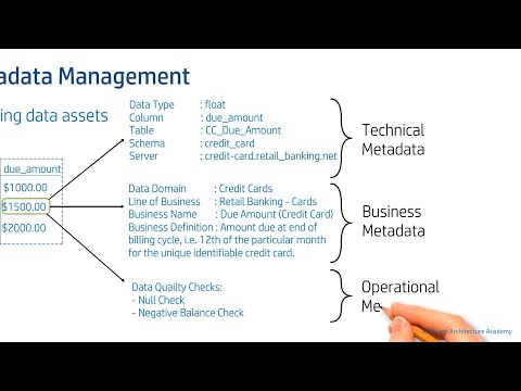
Metadata Management & Data Catalog (Data Architecture | Data Governance)
 0:20:04
What is GIS Data?
 1:27:52
Finding Data for GIS
 1:00:06
Data Management for GIS Projects
 0:38:06
Components of GIS - Components, Metadata, Topology Part1
 0:01:19
GIS: Creating ISO 19115 metadata from REST services
 0:59:31
Navigating NENA Standards: GIS Data Stewardship
Комментарии