filmov
tv
Geodatabase Features and Design - GIS Data Formats, Design and Quality

Показать описание
Link to this course:
Geodatabase Features and Design - GIS Data Formats, Design and Quality
Geographic Information Systems (GIS) Specialization
In this course, the second in the Geographic Information Systems (GIS) Specialization, you will go in-depth with common data types (such as raster and vector data), structures, quality and storage during four week-long modules:
Week 1: Learn about data models and formats, including a full understanding of vector data and raster concepts. You will also learn about the implications of a data’s scale and how to load layers from web services.
Week 2: Create a vector data model by using vector attribute tables, writing query strings, defining queries, and adding and calculating fields. You'll also learn how to create new data through the process of digitizing and you'll use the built-in Editor tools in ArcGIS.
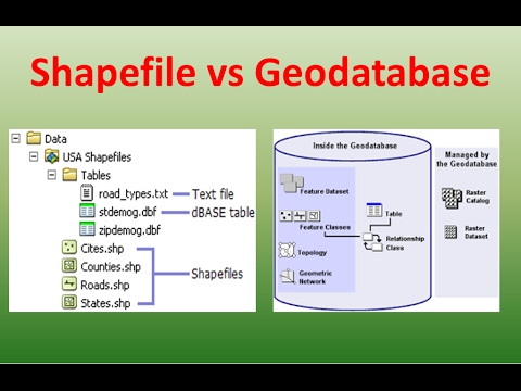
Week 3: Learn about common data storage mechanisms within GIS, including geodatabases and shapefiles. Learn how to choose between them for your projects and how to optimize them for speed and size. You'll also work with rasters for the first time, using digital elevation models and creating slope and distance analysis products.
Week 4: Explore datasets and assess them for quality and uncertainty. You will also learn how to bring your maps and data to the Internet and create web maps quickly with ArcGIS Online.
Take GIS Data Formats, Design and Quality as a standalone course or as part of the Geographic Information Systems (GIS) Specialization. You should have equivalent experience to completing the first course in this specialization, Fundamentals of GIS, before taking this course. By completing the second class in the Specialization you will gain the skills needed to succeed in the full program.
Spatial Analysis, Analytics, Workflow, Data Management
This is a really nice course that lets to go deeper into GIS concepts, at this point one can feel power on the fingertips - ability to create and publish own online maps can not be underestimated!,Nick, you and your team did good job on making the course enjoyable, only problem I faced was having trouble downloading the tutorial 2 assignment data. Still it was a very good experience!!!
This module covers choosing data storage formats for particular purposes as well as tools for working with rasters. In the first lesson, we'll discuss geodatabase design and go over considerations for file geodatabases, personal geodatabases, shapefiles, and SQLite databases. The second lesson covers creating and working with raster data. We'll talk about spatial analysis, georeferencing rasters, raster calculator, and using zonal statistics.
Geodatabase Features and Design - GIS Data Formats, Design and Quality
Copyright Disclaimer under Section 107 of the copyright act 1976, allowance is made for fair use for purposes such as criticism, comment, news reporting, scholarship, and research. Fair use is a use permitted by copyright statute that might otherwise be infringing. Non-profit, educational or personal use tips the balance in favour of fair use.
Geodatabase Features and Design - GIS Data Formats, Design and Quality
Geographic Information Systems (GIS) Specialization
In this course, the second in the Geographic Information Systems (GIS) Specialization, you will go in-depth with common data types (such as raster and vector data), structures, quality and storage during four week-long modules:
Week 1: Learn about data models and formats, including a full understanding of vector data and raster concepts. You will also learn about the implications of a data’s scale and how to load layers from web services.
Week 2: Create a vector data model by using vector attribute tables, writing query strings, defining queries, and adding and calculating fields. You'll also learn how to create new data through the process of digitizing and you'll use the built-in Editor tools in ArcGIS.
Week 3: Learn about common data storage mechanisms within GIS, including geodatabases and shapefiles. Learn how to choose between them for your projects and how to optimize them for speed and size. You'll also work with rasters for the first time, using digital elevation models and creating slope and distance analysis products.
Week 4: Explore datasets and assess them for quality and uncertainty. You will also learn how to bring your maps and data to the Internet and create web maps quickly with ArcGIS Online.
Take GIS Data Formats, Design and Quality as a standalone course or as part of the Geographic Information Systems (GIS) Specialization. You should have equivalent experience to completing the first course in this specialization, Fundamentals of GIS, before taking this course. By completing the second class in the Specialization you will gain the skills needed to succeed in the full program.
Spatial Analysis, Analytics, Workflow, Data Management
This is a really nice course that lets to go deeper into GIS concepts, at this point one can feel power on the fingertips - ability to create and publish own online maps can not be underestimated!,Nick, you and your team did good job on making the course enjoyable, only problem I faced was having trouble downloading the tutorial 2 assignment data. Still it was a very good experience!!!
This module covers choosing data storage formats for particular purposes as well as tools for working with rasters. In the first lesson, we'll discuss geodatabase design and go over considerations for file geodatabases, personal geodatabases, shapefiles, and SQLite databases. The second lesson covers creating and working with raster data. We'll talk about spatial analysis, georeferencing rasters, raster calculator, and using zonal statistics.
Geodatabase Features and Design - GIS Data Formats, Design and Quality
Copyright Disclaimer under Section 107 of the copyright act 1976, allowance is made for fair use for purposes such as criticism, comment, news reporting, scholarship, and research. Fair use is a use permitted by copyright statute that might otherwise be infringing. Non-profit, educational or personal use tips the balance in favour of fair use.
 0:13:40
 0:29:36
 0:15:13
 0:25:39
 0:59:17
 1:03:27
 0:04:03
 0:01:24
 0:11:32
 0:16:20
 0:04:38
 0:04:01
 0:27:19
 0:10:34
 0:41:26
 0:01:32
 0:16:34
 0:04:53
 0:09:24
 0:25:43
 0:03:37
 0:16:00
 0:09:24
 0:54:11