filmov
tv
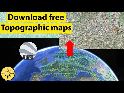
How to download High Resolution Topographic Maps by using Google Earth Pro

Показать описание
In this tutorial, I will show you, how to download High Resolution Topographic Maps by using Google Earth Pro from the online topographic map collections sources of the University of Texas Libraries. To do this, we will also be making use of the Google Earth application, Basically, to view the availability of the topographical maps across the globe and pick the right one that we might potentially be interested in.
============================
Share, Support, Subscribe!!!
Other Useful Tutorial:
=============================
PLEASE HIT LIKE BUTTON!!!!!
SHARE WITH YOUR FRIENDS AND IN SOCIAL MEDIA.
DON'T FORGET TO SUBSCRIBE MY CHANNEL.
=============================
Copyright Disclaimer Under Section 107 of the Copyright Act 1976, allowance is made for "fair use" for purposes such as criticism, comment, news reporting, teaching, scholarship, and research. Fair use is a use permitted by copyright statute that might otherwise be infringing. Non-profit, educational or personal use tips the balance in favor of fair use.
#TopographicMaps, #GoogleEarth, #ScannedMaps,
 0:06:45
🛑How to download High-resolution (0.3m) MAXAR satellite image for free, From OpenAreialMap & use...
 0:02:51
How To Download High Quality Images From GOOGLE - Get High Resolution Photos From Google
 0:02:42
How To Download High Resolution Images From Google Images
 0:03:43
How to download a High Resolution Google Maps Image - [ Easy Google Maps Tutorial ]
 0:06:09
Download High-Resolution Google Maps Images
 0:02:48
How To Download High Resolution Images From Google Images | Save Good Quality HD Pics To Gallery
 0:00:28
How to download high-resolution images of products listed on Amazon 2024
 0:02:09
Download Very High Resolution Google Earth Pro Images Free
 0:03:50
Couldn't load high resolution image Messenger Error Solved
 0:03:04
Download High Resolution image from Google Earth Pro
 0:03:31
Download free high resolution topographic maps
 0:01:55
Download Very High Resolution Google Earth Pro Images Free
 0:05:06
Download high resolution satellite image using QGIS
 0:08:45
Download high resolution (50cm) satellite images from soar | download and upload drone images
 0:07:32
Download High-Resolution Satellite Imagery For Free Upto 15cm Using SAS Planet || #TheGISHub
 0:02:46
How To Find High Resolution Images In Google
 0:10:03
How to download High-resolution (0.3m) MAXAR satellite image for free, From OpenAreialMap.
 0:01:07
How to Search Google for High Resolution Images
 0:02:33
Download High-Resolution Satellite Images for free with QGIS
 0:11:16
How to Download High-Resolution Satellite Images Using QGIS Plugin: A Comprehensive Guide
 0:08:38
How to download high resolution Georeferenced Google Earth Imagery using QGIS for free?
 0:05:37
Download high resolution satellite image using Global Mapper
 0:19:29
Download and print high resolution maps from google earth
 0:00:22
How to Download High-Resolution PNG from Bing AI Image Creator | Insight Junction
Комментарии