filmov
tv
Early Morning Prolific Lightning Storm In San Jose, CA (8-16-20)

Показать описание
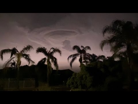
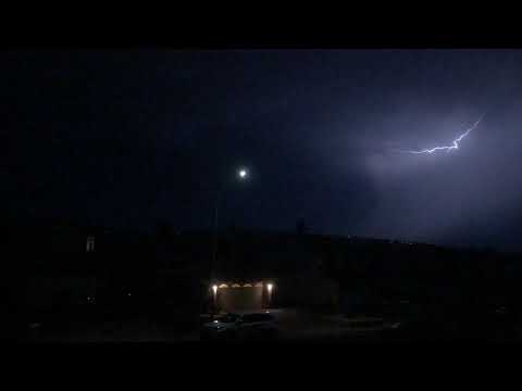
Early morning prolific lightning storm during the predawn hours as a line of storms moved up from the south, right into the Bay Area. Subtropical moisture was being drawn northward towards us. The weather outside felt quite warm & humid. This weather was totally unusual for us here. And yes, this was in San Jose, CA! It really felt as if I was in Florida or the Midwest. In all my years of living here, I’ve never seen anything like this… (Footage taken during the predawn hours of Sunday, August 16, 2020)
*Weather scenario: Rare August severe weather had rolled into the SF Bay Area early Sunday. According to the weather service, the bizarre weather was being spun into the Bay Area from Tropical Storm Fausto off Mexico’s west coast. People across the Bay Area woke to a wild mix of thunder, lightning, high winds, and heavy rain early Sunday morning as t-storms moved over the region before sunrise. Dry lightning was expected, but the t-storms were more severe than expected and, at the end of a week marked by dry heat, the weather was a surprise for many. The weather was unusual for California, which sees little storm activity in the summer… Hundreds of lightning strikes were recorded. NWS forecaster Drew Peterson said at 5 a.m.: "We’re seeing nonstop continuous lightning across the Bay Area," he said. At 5:30 a.m., new storms were firing over the ocean and moving in. More storm activity was expected thru 8 a.m... The combination of lightning and high winds brought a high risk for wildfires and several fire starts have already been reported. The intensity of the storms even triggered an early morning severe t-storm warning for the entire SF Bay Area. Even after it expired, the lightning and thunder continued... About 2,500 cloud-to-ground lightning strikes were recorded during a 12-hour period into Sunday morning over the Bay Area and the Central Coast and were nearly constant, highly unusual for the region. Though the storms delivered a burst of cooler air, clouds and rain, the heat wave was expected to continue as the hot air mass remains settled across the state...
*Weather scenario: Rare August severe weather had rolled into the SF Bay Area early Sunday. According to the weather service, the bizarre weather was being spun into the Bay Area from Tropical Storm Fausto off Mexico’s west coast. People across the Bay Area woke to a wild mix of thunder, lightning, high winds, and heavy rain early Sunday morning as t-storms moved over the region before sunrise. Dry lightning was expected, but the t-storms were more severe than expected and, at the end of a week marked by dry heat, the weather was a surprise for many. The weather was unusual for California, which sees little storm activity in the summer… Hundreds of lightning strikes were recorded. NWS forecaster Drew Peterson said at 5 a.m.: "We’re seeing nonstop continuous lightning across the Bay Area," he said. At 5:30 a.m., new storms were firing over the ocean and moving in. More storm activity was expected thru 8 a.m... The combination of lightning and high winds brought a high risk for wildfires and several fire starts have already been reported. The intensity of the storms even triggered an early morning severe t-storm warning for the entire SF Bay Area. Even after it expired, the lightning and thunder continued... About 2,500 cloud-to-ground lightning strikes were recorded during a 12-hour period into Sunday morning over the Bay Area and the Central Coast and were nearly constant, highly unusual for the region. Though the storms delivered a burst of cooler air, clouds and rain, the heat wave was expected to continue as the hot air mass remains settled across the state...
 0:06:00
 0:07:37
 0:00:39
 0:06:01
 0:02:09
 0:00:08
 0:00:16
 0:04:12
 0:00:48
 0:02:50
 0:00:22
 0:02:46
 0:03:55
 0:01:02
 0:04:23
 0:00:17
 0:01:37
 0:09:59
 0:01:36
 0:03:01
 0:00:34
 0:00:37
 0:00:51