filmov
tv
Weather IQ: Tornadoes

Показать описание
What is a tornado?
A tornado is a narrow, violently rotating column of air that extends from a thunderstorm to the ground. Because wind is invisible, it is hard to see a tornado unless it forms a condensation funnel made up of water droplets, dust and debris. Tornadoes can be among the most violent phenomena of all atmospheric storms we experience.
Where do tornadoes occur?
Tornadoes occur in many parts of the world, including Australia, Europe, Africa, Asia, and South America. Even New Zealand reports about 20 tornadoes each year. Two of the highest concentrations of tornadoes outside the U.S. are Argentina and Bangladesh.
How many tornadoes occur in the U.S. each year?
About 1,200 tornadoes hit the U.S. yearly. Since official tornado records only date back to 1950, we do not know the actual average number of tornadoes that occur each year. Plus, tornado spotting and reporting methods have changed a lot over the last several decades, which means that we are observing more tornadoes that actually happen.
When are tornadoes most likely?
Tornado season usually refers to the time of year the U.S. sees the most tornadoes. The peak “tornado season” for the southern Plains (e.g., Texas, Oklahoma, and Kansas) is from May into early June. On the Gulf coast, it is earlier in the spring. In the northern Plains and upper Midwest (North and South Dakota, Nebraska, Iowa, Minnesota), tornado season is in June or July. But, remember, tornadoes can happen at any time of year. Tornadoes can also happen at any time of day or night, but most tornadoes occur between 4–9 p.m.
What is the difference between a Tornado WATCH and a Tornado WARNING?
A Tornado WATCH is issued by the NOAA Storm Prediction Center meteorologists who watch the weather 24/7 across the entire U.S. for weather conditions that are favorable for tornadoes and severe weather. A watch can cover parts of a state or several states. Watch and prepare for severe weather and stay tuned to NOAA Weather Radio to know when warnings are issued.
A Tornado WARNING is issued by your local NOAA National Weather Service Forecast Office meteorologists who watch the weather 24/7 over a designated area. This means a tornado has been reported by spotters or indicated by radar and there is a serious threat to life and property to those in the path of the tornado. A tornado warning indicates that you should ACT NOW to find safe shelter! A warning can cover parts of counties or several counties in the path of danger.
How is tornado strength rated?
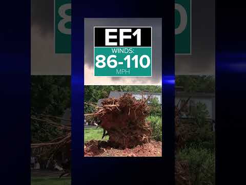
To determine the strength of a tornado, experts examine the damage it caused. From this information, we can estimate the wind speeds. An “Enhanced Fujita Scale” was implemented by the National Weather Service in 2007 to rate tornadoes in a more consistent and accurate manner. The EF-Scale takes into account more variables than the original Fujita Scale (F-Scale) when assigning a wind speed rating to a tornado, incorporating 28 damage indicators such as building type, structures and trees. For each damage indicator, there are 8 degrees of damage ranging from the beginning of visible damage to complete destruction of the damage indicator. The original F-scale did not take these details into account. The original F-Scale historical data base will not change. An F5 tornado rated years ago is still an F5, but the wind speed associated with the tornado may have been somewhat less than previously estimated. A correlation between the original F-Scale and the EF-Scale has been developed. This makes it possible to express ratings in terms of one scale to the other, preserving the historical database.
How do tornadoes form?
The truth is that we don't fully understand. The most destructive tornadoes occur from supercells, which are rotating thunderstorms with a well-defined radar circulation called a mesocyclone. (Supercells can also produce damaging hail, severe non-tornadic winds, frequent lightning, and flash floods.) Tornado formation is believed to be dictated mainly by things which happen on the storm scale, in and around the mesocyclone. Recent theories and results from the VORTEX2 program suggest that once a mesocyclone is underway, tornado development is related to the temperature differences across the edge of downdraft air wrapping around the mesocyclone. Mathematical modeling studies of tornado formation also indicate that it can happen without such temperature patterns; and in fact, very little temperature variation was observed near some of the most destructive tornadoes in history on 3 May 1999. We still have lots of work to do.
Weather IQ is powered by the meteorologists and forecasters at WCNC Charlotte in North Carolina. This channel is dedicating to forecasting, explaining, and educating weather, climate, and atmospheric science to everyone, including teachers, students, and more.
A tornado is a narrow, violently rotating column of air that extends from a thunderstorm to the ground. Because wind is invisible, it is hard to see a tornado unless it forms a condensation funnel made up of water droplets, dust and debris. Tornadoes can be among the most violent phenomena of all atmospheric storms we experience.
Where do tornadoes occur?
Tornadoes occur in many parts of the world, including Australia, Europe, Africa, Asia, and South America. Even New Zealand reports about 20 tornadoes each year. Two of the highest concentrations of tornadoes outside the U.S. are Argentina and Bangladesh.
How many tornadoes occur in the U.S. each year?
About 1,200 tornadoes hit the U.S. yearly. Since official tornado records only date back to 1950, we do not know the actual average number of tornadoes that occur each year. Plus, tornado spotting and reporting methods have changed a lot over the last several decades, which means that we are observing more tornadoes that actually happen.
When are tornadoes most likely?
Tornado season usually refers to the time of year the U.S. sees the most tornadoes. The peak “tornado season” for the southern Plains (e.g., Texas, Oklahoma, and Kansas) is from May into early June. On the Gulf coast, it is earlier in the spring. In the northern Plains and upper Midwest (North and South Dakota, Nebraska, Iowa, Minnesota), tornado season is in June or July. But, remember, tornadoes can happen at any time of year. Tornadoes can also happen at any time of day or night, but most tornadoes occur between 4–9 p.m.
What is the difference between a Tornado WATCH and a Tornado WARNING?
A Tornado WATCH is issued by the NOAA Storm Prediction Center meteorologists who watch the weather 24/7 across the entire U.S. for weather conditions that are favorable for tornadoes and severe weather. A watch can cover parts of a state or several states. Watch and prepare for severe weather and stay tuned to NOAA Weather Radio to know when warnings are issued.
A Tornado WARNING is issued by your local NOAA National Weather Service Forecast Office meteorologists who watch the weather 24/7 over a designated area. This means a tornado has been reported by spotters or indicated by radar and there is a serious threat to life and property to those in the path of the tornado. A tornado warning indicates that you should ACT NOW to find safe shelter! A warning can cover parts of counties or several counties in the path of danger.
How is tornado strength rated?
To determine the strength of a tornado, experts examine the damage it caused. From this information, we can estimate the wind speeds. An “Enhanced Fujita Scale” was implemented by the National Weather Service in 2007 to rate tornadoes in a more consistent and accurate manner. The EF-Scale takes into account more variables than the original Fujita Scale (F-Scale) when assigning a wind speed rating to a tornado, incorporating 28 damage indicators such as building type, structures and trees. For each damage indicator, there are 8 degrees of damage ranging from the beginning of visible damage to complete destruction of the damage indicator. The original F-scale did not take these details into account. The original F-Scale historical data base will not change. An F5 tornado rated years ago is still an F5, but the wind speed associated with the tornado may have been somewhat less than previously estimated. A correlation between the original F-Scale and the EF-Scale has been developed. This makes it possible to express ratings in terms of one scale to the other, preserving the historical database.
How do tornadoes form?
The truth is that we don't fully understand. The most destructive tornadoes occur from supercells, which are rotating thunderstorms with a well-defined radar circulation called a mesocyclone. (Supercells can also produce damaging hail, severe non-tornadic winds, frequent lightning, and flash floods.) Tornado formation is believed to be dictated mainly by things which happen on the storm scale, in and around the mesocyclone. Recent theories and results from the VORTEX2 program suggest that once a mesocyclone is underway, tornado development is related to the temperature differences across the edge of downdraft air wrapping around the mesocyclone. Mathematical modeling studies of tornado formation also indicate that it can happen without such temperature patterns; and in fact, very little temperature variation was observed near some of the most destructive tornadoes in history on 3 May 1999. We still have lots of work to do.
Weather IQ is powered by the meteorologists and forecasters at WCNC Charlotte in North Carolina. This channel is dedicating to forecasting, explaining, and educating weather, climate, and atmospheric science to everyone, including teachers, students, and more.
 0:08:08
 0:03:02
 0:05:48
 0:00:49
 0:01:27
 0:07:22
 0:02:54
 0:02:42
 0:05:52
 0:00:43
 0:00:14
 0:02:14
 0:04:38
 0:01:00
 0:00:49
 0:00:51
 0:00:30
 0:00:59
 0:00:47
 0:10:02
 0:00:57
 0:01:33
 0:02:05
 0:00:56