filmov
tv
HIKING IN CRETE SAMARIA GORGE CHANIA - ΠΕΖΟΠΟΡΙΑ ΣΤΗΝ ΚΡΗΤΗ ΦΑΡΑΓΓΙ ΣΑΜΑΡΙΑΣ .

Показать описание
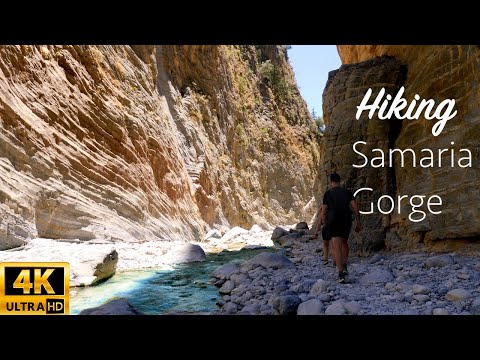
Samaria Gorge is the most famous hiking gorge in Europe, being part of the European path E4. Thousands of tourists walk it in the summer. For many, this is the main purpose of their visit to Crete. Its length reaches 15 km and its descent takes about 5-7 hours, depending on your pace, from Omalos to Agia Roumeli.
It is located on the south side of the Prefecture of Chania. It was created by the river that flows between the main body of the White Mountains and Mount Volakias. There are several other gorges in Samaria, perpendicular to the main gorge, but they are mostly technical (require ropes for canyoning). One of these gorges, Perdika, has a waterfall 240 meters high which together with the waterfall of Mastoras, are considered the tallest in Greece.
The distance of 14.5 km concerns the distance between the settlement of Omalos on the homonymous plateau and the village of Agia Roumeli. In reality, however, the gorge is 13 km, starting at an altitude of 1,250m. at the northern entrance, and ends at the shores of the South Cretan Sea in Agia Roumeli. The course through the White Mountains National Park, ie from the outpost in Xyloskalo to the outpost in the old village of Agia Roumeli, is 13 km. From there you will have to walk another 1.5 km to the beach of Agia Roumeli, making the total route 14.5 km.
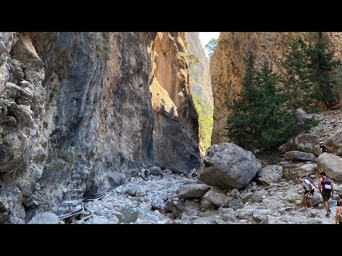
The most famous part of the gorge is the place known as Portes or Sideroportes, where its sides come at a distance of only 4m., While they rise to a height of 500m.! The gorge became a national park in 1962, mainly acting as a refuge for the endangered Cretan chamois, which is now limited to Samaria, Theodoros Island and other islets in various parts of Greece. There are many species of fauna and flora that are endemic to the gorge and the surrounding area.
The problem of Samaria is the large crowds that cross the gorge. It has become one of the most popular places in Crete and there are up to 3,000 visitors a day in high season. If you are unlucky enough to choose one of those days, be sure to start at dawn (before the arrival of the many tour buses) it will give you a very significant lead. To do this, you can stay in a cheap and good room in Omalos or take the first bus from Chania. The first tourist buses arrive at around 7:30 a.m. and since then a continuous flow of buses begins until about 11:00 a.m.
As for what time of year is best to cross the gorge, clearly this is spring: the weather is still cool, the vegetation is at its best and the river has a lot of water. The worst time is in the middle of summer, especially during a heat wave.
Opening: May 1 - October 31, opens at 7:00. Due to adverse weather conditions, the gorge may remain closed, it is advisable to contact Xyloskalo at 2821067179.
Το Φαράγγι της Σαμαριάς είναι το διασημότερο πεζοπορικό φαράγγι της Ευρώπης, αποτελώντας τμήμα του Ευρωπαϊκού μονοπατιού Ε4. Χιλιάδες τουρίστες το κατεβαίνουν με τα πόδια το καλοκαίρι. Για πολλούς αυτός είναι και ο κύριος σκοπός της επίσκεψής τους στην Κρήτη. Το μήκος του αγγίζει τα 15 χλμ και η κατάβαση του διαρκεί περίπου 5-7 ώρες, ανάλογα το ρυθμό σας, από τον Ομαλό ως την Αγία Ρουμέλη.
Βρίσκεται στη νότια πλευρά του Νομού Χανίων. Δημιουργήθηκε από το ποτάμι που ρέει ανάμεσα στον κύριο όγκο των Λευκών Ορέων και το όρος Βολακιάς. Υπάρχουν διάφορα άλλα φαράγγια στη Σαμαριά, κάθετα στο κυρίως φαράγγι, αλλά είναι κυρίως τεχνικά (απαιτούν σκοινιά για canyoning). Ένα από αυτά τα φαράγγια, η Πέρδικα, έχει ένα καταρράκτη ύψους 240 μέτρων που μαζί με τον καταρράκτη του Μάστορα, θεωρούνται οι ψηλότεροι στην Ελλάδα.
Η απόσταση των 14.5 χλμ αφορά την απόσταση μεταξύ του οικισμού του Ομαλού στο ομώνυμο οροπέδιο και το χωριό Αγία Ρουμέλη. Στην πραγματικότητα όμως, το φαράγγι είναι 13 χλμ., ξεκινώντας σε υψόμετρο 1.250μ. στην βόρεια είσοδο, και τελειώνει στις ακτές του Νοτιου Κρητικού Πελάγους στην Αγία Ρουμέλη. Η πορεία μέσα στον Εθνικό Δρυμό των Λευκών Ορέων, δηλαδή από το φυλάκιο στο Ξυλόσκαλο ως το φυλάκιο στο παλιό χωριό της Αγίας Ρουμέλης, είναι 13 χλμ. Από εκεί όμως θα πρέπει να περπατήσετε κι άλλο 1.5 χλμ ως την παραλία της Αγίας Ρουμέλης, κάνοντας τη συνολική διαδρομή 14,5 χλμ.
Το πιο γνωστό μέρος του φαραγγιού είναι το σημείο γνωστό ως Πόρτες ή Σιδερόπορτες, όπου οι πλευρές του έρχονται σε απόσταση μόλις 4μ., ενώ υψώνονται σε ύψος 500μ.! Το φαράγγι έγινε εθνικός δρυμός το 1962, κυρίως λειτουργώντας ως καταφύγιο για τον απειλούμενο Κρητικό αίγαγρο, ο οποίος περιορίζεται σήμερα στη Σαμαριά, στο νησί Θοδωρού αλλά και σε άλλες νησίδες σε διάφορα μέρη της Ελλάδος. Υπάρχουν πολλά είδη πανίδας και χλωρίδας που ενδημούν στο φαράγγι και τη γύρω περιοχή.
It is located on the south side of the Prefecture of Chania. It was created by the river that flows between the main body of the White Mountains and Mount Volakias. There are several other gorges in Samaria, perpendicular to the main gorge, but they are mostly technical (require ropes for canyoning). One of these gorges, Perdika, has a waterfall 240 meters high which together with the waterfall of Mastoras, are considered the tallest in Greece.
The distance of 14.5 km concerns the distance between the settlement of Omalos on the homonymous plateau and the village of Agia Roumeli. In reality, however, the gorge is 13 km, starting at an altitude of 1,250m. at the northern entrance, and ends at the shores of the South Cretan Sea in Agia Roumeli. The course through the White Mountains National Park, ie from the outpost in Xyloskalo to the outpost in the old village of Agia Roumeli, is 13 km. From there you will have to walk another 1.5 km to the beach of Agia Roumeli, making the total route 14.5 km.
The most famous part of the gorge is the place known as Portes or Sideroportes, where its sides come at a distance of only 4m., While they rise to a height of 500m.! The gorge became a national park in 1962, mainly acting as a refuge for the endangered Cretan chamois, which is now limited to Samaria, Theodoros Island and other islets in various parts of Greece. There are many species of fauna and flora that are endemic to the gorge and the surrounding area.
The problem of Samaria is the large crowds that cross the gorge. It has become one of the most popular places in Crete and there are up to 3,000 visitors a day in high season. If you are unlucky enough to choose one of those days, be sure to start at dawn (before the arrival of the many tour buses) it will give you a very significant lead. To do this, you can stay in a cheap and good room in Omalos or take the first bus from Chania. The first tourist buses arrive at around 7:30 a.m. and since then a continuous flow of buses begins until about 11:00 a.m.
As for what time of year is best to cross the gorge, clearly this is spring: the weather is still cool, the vegetation is at its best and the river has a lot of water. The worst time is in the middle of summer, especially during a heat wave.
Opening: May 1 - October 31, opens at 7:00. Due to adverse weather conditions, the gorge may remain closed, it is advisable to contact Xyloskalo at 2821067179.
Το Φαράγγι της Σαμαριάς είναι το διασημότερο πεζοπορικό φαράγγι της Ευρώπης, αποτελώντας τμήμα του Ευρωπαϊκού μονοπατιού Ε4. Χιλιάδες τουρίστες το κατεβαίνουν με τα πόδια το καλοκαίρι. Για πολλούς αυτός είναι και ο κύριος σκοπός της επίσκεψής τους στην Κρήτη. Το μήκος του αγγίζει τα 15 χλμ και η κατάβαση του διαρκεί περίπου 5-7 ώρες, ανάλογα το ρυθμό σας, από τον Ομαλό ως την Αγία Ρουμέλη.
Βρίσκεται στη νότια πλευρά του Νομού Χανίων. Δημιουργήθηκε από το ποτάμι που ρέει ανάμεσα στον κύριο όγκο των Λευκών Ορέων και το όρος Βολακιάς. Υπάρχουν διάφορα άλλα φαράγγια στη Σαμαριά, κάθετα στο κυρίως φαράγγι, αλλά είναι κυρίως τεχνικά (απαιτούν σκοινιά για canyoning). Ένα από αυτά τα φαράγγια, η Πέρδικα, έχει ένα καταρράκτη ύψους 240 μέτρων που μαζί με τον καταρράκτη του Μάστορα, θεωρούνται οι ψηλότεροι στην Ελλάδα.
Η απόσταση των 14.5 χλμ αφορά την απόσταση μεταξύ του οικισμού του Ομαλού στο ομώνυμο οροπέδιο και το χωριό Αγία Ρουμέλη. Στην πραγματικότητα όμως, το φαράγγι είναι 13 χλμ., ξεκινώντας σε υψόμετρο 1.250μ. στην βόρεια είσοδο, και τελειώνει στις ακτές του Νοτιου Κρητικού Πελάγους στην Αγία Ρουμέλη. Η πορεία μέσα στον Εθνικό Δρυμό των Λευκών Ορέων, δηλαδή από το φυλάκιο στο Ξυλόσκαλο ως το φυλάκιο στο παλιό χωριό της Αγίας Ρουμέλης, είναι 13 χλμ. Από εκεί όμως θα πρέπει να περπατήσετε κι άλλο 1.5 χλμ ως την παραλία της Αγίας Ρουμέλης, κάνοντας τη συνολική διαδρομή 14,5 χλμ.
Το πιο γνωστό μέρος του φαραγγιού είναι το σημείο γνωστό ως Πόρτες ή Σιδερόπορτες, όπου οι πλευρές του έρχονται σε απόσταση μόλις 4μ., ενώ υψώνονται σε ύψος 500μ.! Το φαράγγι έγινε εθνικός δρυμός το 1962, κυρίως λειτουργώντας ως καταφύγιο για τον απειλούμενο Κρητικό αίγαγρο, ο οποίος περιορίζεται σήμερα στη Σαμαριά, στο νησί Θοδωρού αλλά και σε άλλες νησίδες σε διάφορα μέρη της Ελλάδος. Υπάρχουν πολλά είδη πανίδας και χλωρίδας που ενδημούν στο φαράγγι και τη γύρω περιοχή.
 0:23:33
Hiking Samaria Gorge in Crete 4K (relaxing nature ASMR)
 0:04:16
Hiking The Beautiful Samaria Gorge In Crete Greece - Traveling To Greece 2022
 0:08:26
SAMARIA GORGE: How it's like to HIKE 16 km in Crete, Greece | Island Hiking
 0:17:12
HIKING IN SAMARIA GORGE | CRETE GREECE | Mountains, Ruins, Beaches & Epic Views
 1:06:45
Hiking Samaria Gorge, the second longest gorge in Europe - Crete, Greece, 2023
 0:11:26
Hiking The AMAZING Samaria Gorge ft. Hives + Heatstroke
 0:00:59
Samaria Gorge Hiking Tips We Wish We Knew Before #crete #hiking #greecetravel
 0:03:47
Hiking the Samaria Gorge on Crete
 0:17:27
BEST HIKE IN GREECE: SAMARIA GORGE || TRAVEL CRETE, GREECE
 0:29:09
Epic Samaria Gorge Hike in Crete Greece!
 0:08:59
Exciting Samaria Gorge hike on Crete 🇬🇷
 0:19:38
Hiking the Samaria Gorge on Crete in Greece. Is it the prettiest gorge in Europe?
 0:01:01
Hiking Samaria Gorge in Crete (longest gorge in Europe) 🇬🇷🥾
 0:00:13
16km long Samaria Gorge is a must do if you are visiting Crete.Get ready for full day hike!#crete
 0:11:39
Top 10 Gorges of Crete (NOT Samaria, Imbros or Agia Irini) | Hiking Guide Crete
 0:00:16
Amazing Samaria Gorge ⛰️🇬🇷🌊 #samaria #hiking #crete #greece
 0:13:10
Hiking 16 km through the Samaria Gorge, Crete
 0:27:56
Best hikes in Crete
 0:10:10
Hiking Samaria Gorge || Crete, Greece
 0:15:36
Hiking the Samaria Gorge, Crete!
 0:13:37
The best hike ever! Samaria Gorge in Crete.
 0:00:10
This is Samaria Gorge in Crete & it’s the longest gorge in Europe! (16km) 🥾🇬🇷
 0:00:11
Samaria Gorge Hiking 2021 - Vacation in Crete
 0:00:30
Hiking The Samaria Gorge In Crete Greece
Комментарии