filmov
tv
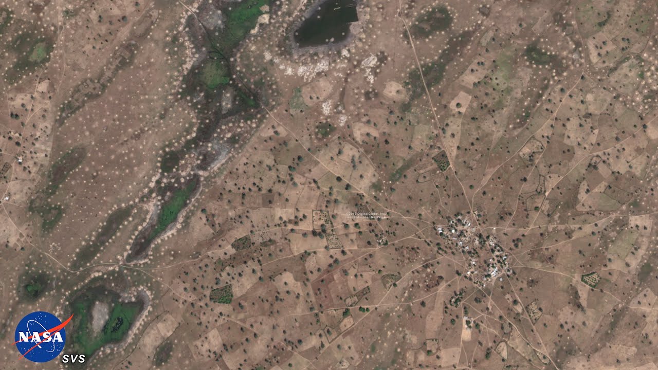
NASA Supercomputing Study Breaks Ground for Tree Mapping, Carbon Research
Показать описание
Scientists from NASA’s Goddard Space Flight Center in Greenbelt, Maryland and international collaborators demonstrated a new method for mapping the location and size of trees growing outside of forests, discovering surprisingly high numbers of trees in semi-arid regions and laying the groundwork for more accurate global measurement of carbon storage on land.
 0:01:09
NASA Supercomputing Study Breaks Ground for Tree Mapping, Carbon Research
 0:00:57
Ex-NASA Engineer To Plant One Billion Trees Using Drones
 0:02:33
Supercomputing in Space
 0:02:19
NASA Models Methane Sources and Movement Around the Globe
 0:03:12
Elon Musk, why are you still working? You are worth $184B
 0:01:06
Machine Learning and Simulations Support NASA Astronaut Health
 0:10:35
Why Observe?: Tree Height
 0:01:21
La NASA ouvre la voie à la cartographie des arbres grâce aux supercomputeurs
 0:46:36
FM16 Press Conference: Defending the home planet
 0:18:55
AI says why it will kill us all. Experts agree.
 0:02:20
NASA's Nancy Grace Roman Space Telescope: Broadening Our Cosmic Horizons
 0:10:45
Scientific Visualization Studio
 0:18:13
Quantum Computers, explained with MKBHD
 0:02:49
Swift Links Neutrino to Star-destroying Black Hole
 0:02:07
Share Your Science: Mapping the Earth’s Interior with GPUs
 0:01:01
An Unexpectedly Large Count of Trees in the West African Sahara and Sahel
 0:11:58
How Satellite Imagery and AI Satellite Applications Will Change the Future
 0:21:11
NASA JUST ANNOUNCED San Andreas Fault Crack on the Brink of Eruption After New Findings!
 0:57:17
Focusing in on Other Worlds
 0:13:40
How SpaceX and NASA Plan To Build A Mars Colony!
 0:03:21
NASA Missions Team Up to Study Unique Magnetar Outburst
 0:08:03
Photon Phriday: One Phull Orbit
 0:01:26
Hubble Trivia: 14) Hubble observed what kind of explosion created by two neutron stars merging?
 0:06:36
The Race to Build the World’s Fastest Supercomputers | WSJ U.S. vs. China
Комментарии