filmov
tv
GIS: What Is It? Geographic Information Systems (GIS) in Everyday Life!
Показать описание
Geographic Information Systems (GIS) in Everyday Life:
When you go about your daily routine, you encounter various elements like roadblocks, your favorite bakery, unsafe roads, traffic, railway crossings, and bridges. All of this information is valuable for town planners, engineers, and anyone seeking to make informed decisions.
Download presentation and the important resources:
GIS and Its Significance:
GIS stands for Geographic Information System. The "G" represents geography (places on Earth), the "I" stands for information (what is where, when, and the associated time), and the "S" represents the system for input, storage, analysis, and display of spatial information using software and hardware.
GIS and Maps:
GIS technology allows you to take all this information and display it on a map. This map can help you find the shortest route, avoid traffic, and make decisions based on the spatial data available. GPS navigation services like Google Maps offer a glimpse of GIS functionality, but GIS goes beyond by incorporating layers of data from the real world.
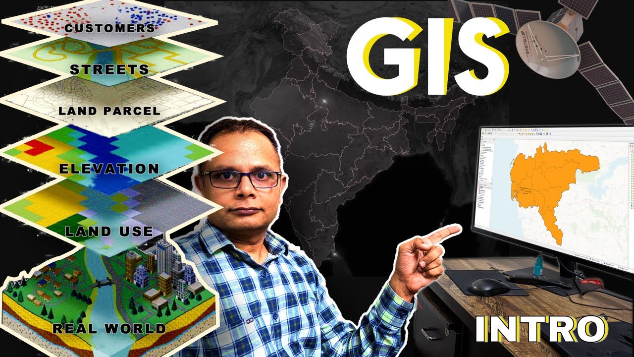
Layers in GIS:
GIS stores data in layers, and these layers represent real-world elements. Layers are composed of spatial (geometric shapes like points, lines, and polygons) and non-spatial data. Spatial data is tied to real-world locations using latitude and longitude coordinates, and sometimes elevation for 3D representation.
Spatial Data Representation:
Points: Represent locations without dimensions, like hospital locations or crime spots.
Lines: Represent linear features like roads and streets.
Polygons: Represent areas, with examples including city boundaries or farm fields.
Components of GIS:
Software: Computer programs (e.g., ArcGIS, Q-GIS) used to manipulate, analyze, and visualize GIS data.
Hardware: Ranges from computer systems to satellites used to capture GIS data.
**Data
Chapters
00:00 -Introduction to GIS
00:41 -Compiling Information in Map for GIS
01:18 -GIS Definition
01:40 -GPS Vs GIS
02:20 -How GIS information used using GIS layers
03:00 -Spatial data, Latitude, Longitude and Elevation data
04:01 -Components of GIS software, hardware, data, Methods and People
05:28 -GIS data structure
gis,
qgis,
arcgis,
arcgis pro,
gis mapping,
arcmap,
geospatial,
geospatial data,
gis data,
When you go about your daily routine, you encounter various elements like roadblocks, your favorite bakery, unsafe roads, traffic, railway crossings, and bridges. All of this information is valuable for town planners, engineers, and anyone seeking to make informed decisions.
Download presentation and the important resources:
GIS and Its Significance:
GIS stands for Geographic Information System. The "G" represents geography (places on Earth), the "I" stands for information (what is where, when, and the associated time), and the "S" represents the system for input, storage, analysis, and display of spatial information using software and hardware.
GIS and Maps:
GIS technology allows you to take all this information and display it on a map. This map can help you find the shortest route, avoid traffic, and make decisions based on the spatial data available. GPS navigation services like Google Maps offer a glimpse of GIS functionality, but GIS goes beyond by incorporating layers of data from the real world.
Layers in GIS:
GIS stores data in layers, and these layers represent real-world elements. Layers are composed of spatial (geometric shapes like points, lines, and polygons) and non-spatial data. Spatial data is tied to real-world locations using latitude and longitude coordinates, and sometimes elevation for 3D representation.
Spatial Data Representation:
Points: Represent locations without dimensions, like hospital locations or crime spots.
Lines: Represent linear features like roads and streets.
Polygons: Represent areas, with examples including city boundaries or farm fields.
Components of GIS:
Software: Computer programs (e.g., ArcGIS, Q-GIS) used to manipulate, analyze, and visualize GIS data.
Hardware: Ranges from computer systems to satellites used to capture GIS data.
**Data
Chapters
00:00 -Introduction to GIS
00:41 -Compiling Information in Map for GIS
01:18 -GIS Definition
01:40 -GPS Vs GIS
02:20 -How GIS information used using GIS layers
03:00 -Spatial data, Latitude, Longitude and Elevation data
04:01 -Components of GIS software, hardware, data, Methods and People
05:28 -GIS data structure
gis,
qgis,
arcgis,
arcgis pro,
gis mapping,
arcmap,
geospatial,
geospatial data,
gis data,
 0:08:03
 0:04:08
 0:05:11
 0:05:32
 0:08:42
 0:10:34
 0:16:01
 0:02:35
 2:51:40
 0:01:27
 0:00:29
 0:40:50
 0:00:30
 0:09:30
 0:14:45
 0:02:47
 0:08:43
 0:06:33
 0:04:13
 0:35:23
 0:03:44
 0:21:42
 0:01:09
 0:05:09